Viborillas elevation
Viborillas (Querétaro, Colón), Mexico elevation is 1915 meters and Viborillas elevation in feet is 6283 ft above sea level [src 1]. Viborillas is a populated place (feature code) with elevation that is 601 meters (1972 ft) bigger than average city elevation in Mexico.
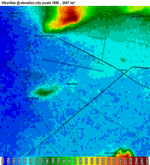
Below is the Elevation map of Viborillas, which displays elevation range with different colors. Scale of the first map is from 1890 to 2057 m (6201 to 6749 ft) with average elevation of 1916.4 meters (=6287 ft) [note 1]
These maps also provides idea of topography and contour of this city, they are displayed at different zoom levels. More info about maps, scale and edge coordinates you can find below images.
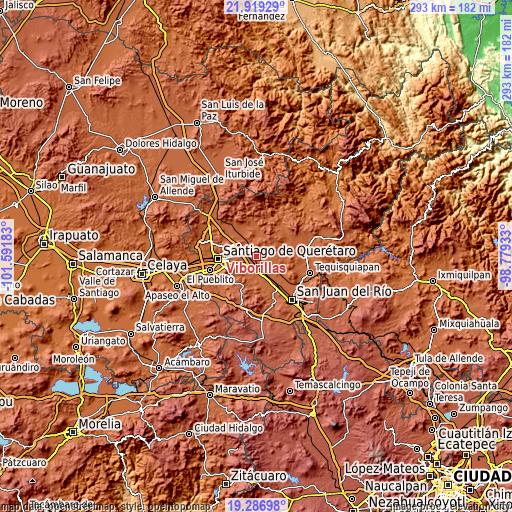
| \ | Map #1 | Topo.Map |
| Scale [m] | 1890..2057 m | × |
| Scale [ft] | 6201..6749 ft | × |
| Average | 1916.4 m = 6287 ft | × |
| Width | 9.15 km = 5.7 mi | 292.7 km = 181.9 mi |
| Height | 9.15 km = 5.7 mi | 292.7 km = 181.9 mi |
| ↑Max Latitude | 20.649947° | 21.91929° |
| Latitude at center | 20.60882° | 20.60882° |
| ↓Min Latitude | 20.567681° | 19.28698° |
| ← Min Longitude | -100.229525° | -101.59183° |
| Longitude center | -100.18558° | -100.18558° |
| →Max Longitude | -100.141635° | -98.77933° |
Nearby cities:
Cities around Viborillas sort by population:
• Epigmenio González elevation 1929 m
6.8 km,  161°
161°
• Jesús María 1900 m
7.5 km,  281°
281°
• San Ildefonso 1926 m
4.8 km, 163°
• Galeras 1920 m
3.1 km,  71°
71°
• Agua Azul 1948 m
2.1 km,  251°
251°
• Coyotillos 1912 m
2.7 km, 246°
• Calamanda 1915 m
6.9 km,  180°
180°
• Purísima de Cubos (La Purísima) 1916 m
7.1 km,  97°
97°
• San Vicente el Alto 1922 m
5 km,  154°
154°
• Paseos del Marqués 1910 m
5.7 km,  264°
264°
• La Loma 1913 m
5.6 km, 259°
• El Paraíso 1913 m
5.9 km,  212°
212°
Multilingual:
 En español:
Viborillas elevación 1915 m.
 En France:
Viborillas élévation 1915 m.
 Auf Deutsch:
Viborillas höhe über dem Meeresspiegel ist 1915 m.

Sources and notes:
- [note 1] Map square and city borders are not equal. Map elevation data is calculated only from area inside that square.
- [src 1] Elevation data from geonames database provided with same terms of usage.
- [src 2] The elevation map of Viborillas is generated using elevation data from NASA's 3 arcsec (90m) resolution SRTM data.
- [src 3] Base (background) map © OpenStreetMap contributors tiles are generated by Geofabrik and OpenTopoMap.
Copyright & License:
This Viborillas Elevation Map is licensed under CC BY-SA. You may reuse any part from this page, if you give a proper credit by linking to this URL:
 More info on terms of use page.