Aldama elevation
Aldama (Guanajuato, Irapuato), Mexico elevation is 1779 meters and Aldama elevation in feet is 5837 ft above sea level [src 1]. Aldama is a populated place (feature code) with elevation that is 465 meters (1526 ft) bigger than average city elevation in Mexico.
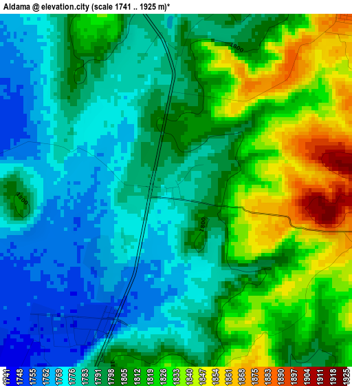
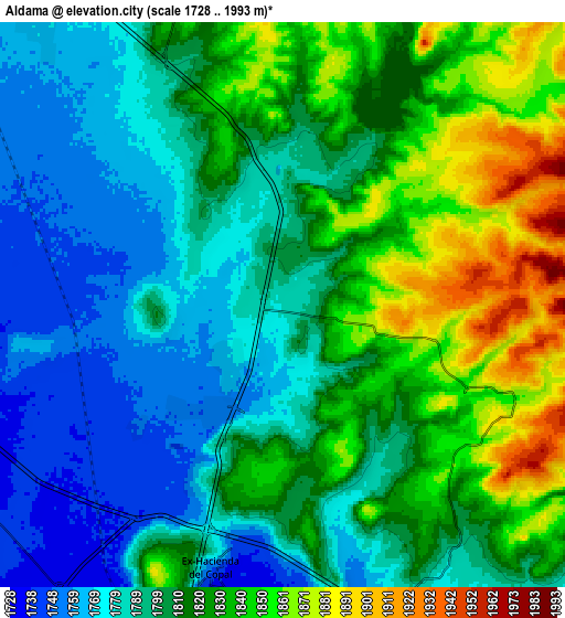
Below is the Elevation map of Aldama, which displays elevation range with different colors. Scale of the first map is from 1741 to 1925 m (5712 to 6316 ft) with average elevation of 1800.4 meters (=5907 ft) [note 1]
These maps also provides idea of topography and contour of this city, they are displayed at different zoom levels. More info about maps, scale and edge coordinates you can find below images.
| \ | Map #1 | Map #2 | Topo.Map |
| Scale [m] | 1741..1925 m | 1728..1993 m | × |
| Scale [ft] | 5712..6316 ft | 5669..6539 ft | × |
| Average | 1800.4 m = 5907 ft | 1810.3 m = 5939 ft | × |
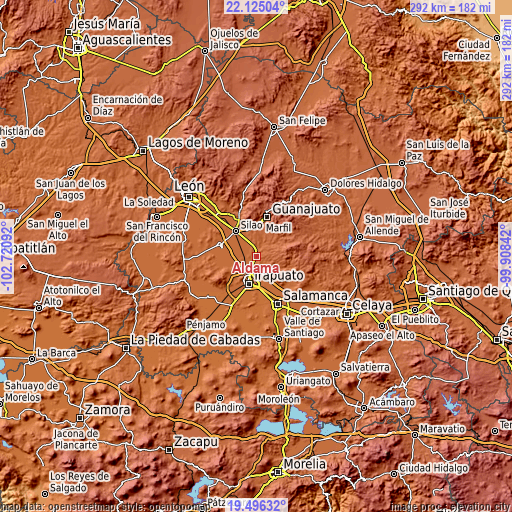
| Width | 9.13 km = 5.7 mi | 18.27 km = 11.4 mi | 292.3 km = 181.6 mi |
| Height | 9.13 km = 5.7 mi | 18.27 km = 11.4 mi | 292.3 km = 181.6 mi |
| ↑Max Latitude | 20.857481° | 20.898541° | 22.12504° |
| Latitude at center | 20.81641° | 20.81641° | 20.81641° |
| ↓Min Latitude | 20.775328° | 20.734234° | 19.49632° |
| ← Min Longitude | -101.358615° | -101.402561° | -102.72092° |
| Longitude center | -101.31467° | -101.31467° | -101.31467° |
| →Max Longitude | -101.270725° | -101.226779° | -99.90842° |
Nearby cities:
Cities around Aldama sort by population:
• La Calera elevation 1769 m
2.5 km,  226°
226°
• Lo de Juárez 1768 m
6 km,  207°
207°
• San José de Llanos 1790 m
4.4 km,  7°
7°
• San Antonio el Rico 1751 m
6 km,  277°
277°
• Hacienda de Márquez 1748 m
6.2 km, 229°
• Purísima del Progreso 1762 m
3 km, 212°
• San Vicente 1783 m
3.1 km,  296°
296°
• Los Nicolases 1788 m
4.6 km,  356°
356°
• Zangarro (Zangarro Nuevo) 1878 m
6.4 km,  43°
43°
• Molino de Santa Ana 1763 m
3.9 km,  290°
290°
• Taretán 1766 m
4.7 km, 207°
• Rancho Nuevo del Llanito 1751 m
5.7 km, 278°
Multilingual:
 En español:
Aldama elevación 1779 m.
 En France:
Aldama élévation 1779 m.


Sources and notes:
- [note 1] Map square and city borders are not equal. Map elevation data is calculated only from area inside that square.
- [src 1] Elevation data from geonames database provided with same terms of usage.
- [src 2] The elevation map of Aldama is generated using elevation data from NASA's 3 arcsec (90m) resolution SRTM data.
- [src 3] Base (background) map © OpenStreetMap contributors tiles are generated by Geofabrik and OpenTopoMap.
Copyright & License:
This Aldama Elevation Map is licensed under CC BY-SA. You may reuse any part from this page, if you give a proper credit by linking to this URL:
 More info on terms of use page.