Alista elevation
Alista (Jalisco, San Gabriel), Mexico elevation is 1352 meters and Alista elevation in feet is 4436 ft above sea level [src 1]. Alista is a populated place (feature code) with elevation that is 38 meters (125 ft) bigger than average city elevation in Mexico.
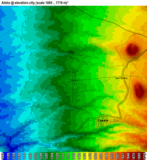
Below is the Elevation map of Alista, which displays elevation range with different colors. Scale of the first map is from 1085 to 1719 m (3560 to 5640 ft) with average elevation of 1329.3 meters (=4361 ft) [note 1]
These maps also provides idea of topography and contour of this city, they are displayed at different zoom levels. More info about maps, scale and edge coordinates you can find below images.
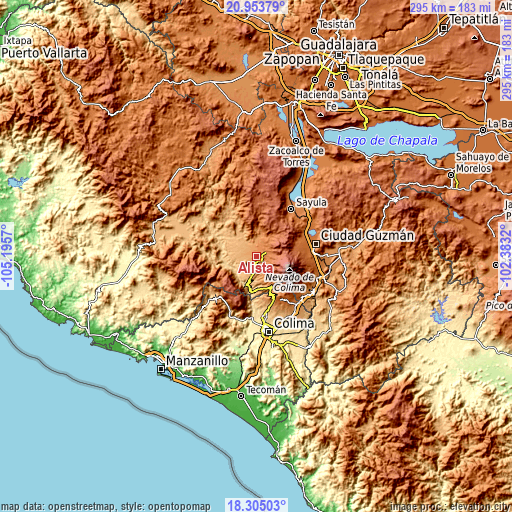
| \ | Map #1 | Topo.Map |
| Scale [m] | 1085..1719 m | × |
| Scale [ft] | 3560..5640 ft | × |
| Average | 1329.3 m = 4361 ft | × |
| Width | 9.2 km = 5.7 mi | 294.5 km = 183 mi |
| Height | 9.2 km = 5.7 mi | 294.5 km = 183 mi |
| ↑Max Latitude | 19.676255° | 20.95379° |
| Latitude at center | 19.63487° | 19.63487° |
| ↓Min Latitude | 19.593475° | 18.30503° |
| ← Min Longitude | -103.833395° | -105.1957° |
| Longitude center | -103.78945° | -103.78945° |
| →Max Longitude | -103.745505° | -102.3832° |
Nearby cities:
Cities around Alista sort by population:
• San Gabriel elevation 806 m
26.5 km,  303°
303°
• San Gabriel 1266 m
12.8 km,  10°
10°
• Suchitlán 1058 m
30 km,  164°
164°
• Zapotitlán de Vadillo 1147 m
9.8 km,  193°
193°
• Tonaya 824 m
25.4 km,  311°
311°
• Copala 1435 m
3.2 km,  145°
145°
• Jiquilpan 1301 m
16.1 km,  3°
3°
• Cofradía de Suchitlán 1295 m
26.7 km, 159°
• Tuxcacuesco 727 m
21.6 km,  289°
289°
• Tolimán 744 m
13.7 km,  254°
254°
• El Jazmín 1705 m
8.6 km,  76°
76°
• Las Primaveras [Invernadero] 1145 m
8.1 km,  325°
325°
Multilingual:
 En español:
Alista elevación 1352 m.
 En France:
Alista élévation 1352 m.


Sources and notes:
- [note 1] Map square and city borders are not equal. Map elevation data is calculated only from area inside that square.
- [src 1] Elevation data from geonames database provided with same terms of usage.
- [src 2] The elevation map of Alista is generated using elevation data from NASA's 3 arcsec (90m) resolution SRTM data.
- [src 3] Base (background) map © OpenStreetMap contributors tiles are generated by Geofabrik and OpenTopoMap.
Copyright & License:
This Alista Elevation Map is licensed under CC BY-SA. You may reuse any part from this page, if you give a proper credit by linking to this URL:
 More info on terms of use page.