Amazcala elevation
Amazcala (Querétaro, El Marqués), Mexico elevation is 1920 meters and Amazcala elevation in feet is 6299 ft above sea level [src 1]. Amazcala is a populated place (feature code) with elevation that is 606 meters (1988 ft) bigger than average city elevation in Mexico.
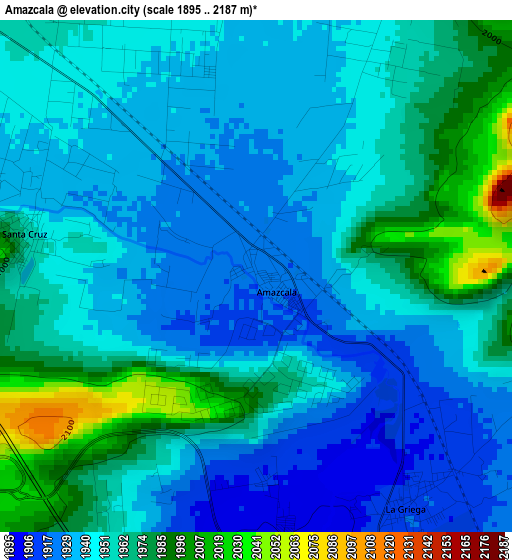
Below is the Elevation map of Amazcala, which displays elevation range with different colors. Scale of the first map is from 1895 to 2187 m (6217 to 7175 ft) with average elevation of 1951.7 meters (=6403 ft) [note 1]
These maps also provides idea of topography and contour of this city, they are displayed at different zoom levels. More info about maps, scale and edge coordinates you can find below images.
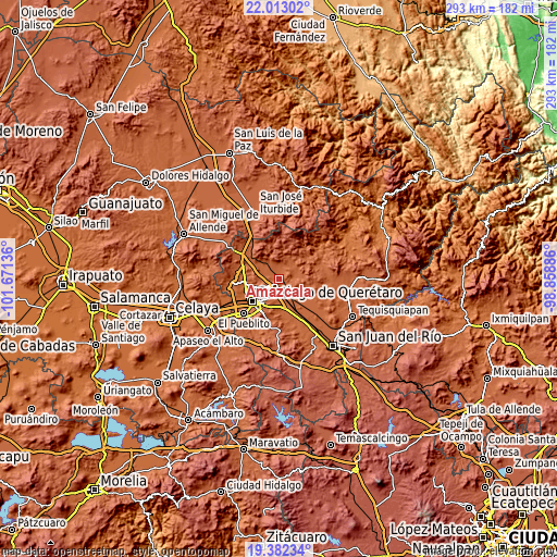
| \ | Map #1 | Map #2 | Topo.Map |
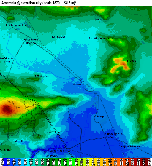
| Scale [m] | 1895..2187 m | 1870..2316 m | × |
| Scale [ft] | 6217..7175 ft | 6135..7598 ft | × |
| Average | 1951.7 m = 6403 ft | 1972.8 m = 6472 ft | × |
| Width | 9.14 km = 5.7 mi | 18.28 km = 11.4 mi | 292.5 km = 181.8 mi |
| Height | 9.14 km = 5.7 mi | 18.28 km = 11.4 mi | 292.5 km = 181.8 mi |
| ↑Max Latitude | 20.744492° | 20.785583° | 22.01302° |
| Latitude at center | 20.70339° | 20.70339° | 20.70339° |
| ↓Min Latitude | 20.662277° | 20.621153° | 19.38234° |
| ← Min Longitude | -100.309055° | -100.353001° | -101.67136° |
| Longitude center | -100.26511° | -100.26511° | -100.26511° |
| →Max Longitude | -100.221165° | -100.177219° | -98.85886° |
Nearby cities:
Cities around Amazcala sort by population:
• Saldarriaga elevation 1895 m
8.9 km,  199°
199°
• La Griega 1912 m
4.9 km,  147°
147°
• Santa Cruz 1950 m
4.2 km,  282°
282°
• Atongo 1978 m
8.2 km,  18°
18°
• Jesús María 1900 m
9 km,  174°
174°
• Alfajayucan 1988 m
7.5 km,  41°
41°
• Hacienda la Cruz [Fraccionamiento] 1891 m
7.8 km,  178°
178°
• San Vicente Ferrer 1951 m
8.8 km,  287°
287°
• Santa María Begoña 1959 m
7.3 km,  311°
311°
• San Rafael 1960 m
5.9 km,  338°
338°
• El Lobo 2018 m
7.1 km,  66°
66°
• San Miguel Amazcala 1985 m
6.1 km,  30°
30°
Multilingual:
 En español:
Amazcala, Amascala elevación 1920 m.
 En France:
Amazcala élévation 1920 m.
 Auf Deutsch:
Amazcala höhe über dem Meeresspiegel ist 1920 m.

Sources and notes:
- [note 1] Map square and city borders are not equal. Map elevation data is calculated only from area inside that square.
- [src 1] Elevation data from geonames database provided with same terms of usage.
- [src 2] The elevation map of Amazcala is generated using elevation data from NASA's 3 arcsec (90m) resolution SRTM data.
- [src 3] Base (background) map © OpenStreetMap contributors tiles are generated by Geofabrik and OpenTopoMap.
Copyright & License:
This Amazcala Elevation Map is licensed under CC BY-SA. You may reuse any part from this page, if you give a proper credit by linking to this URL:
 More info on terms of use page.