Atoyac elevation
Atoyac (Jalisco), Mexico elevation is 1356 meters and Atoyac elevation in feet is 4449 ft above sea level [src 1]. Atoyac is a seat of a second-order administrative division (feature code) with elevation that is 42 meters (138 ft) bigger than average city elevation in Mexico.
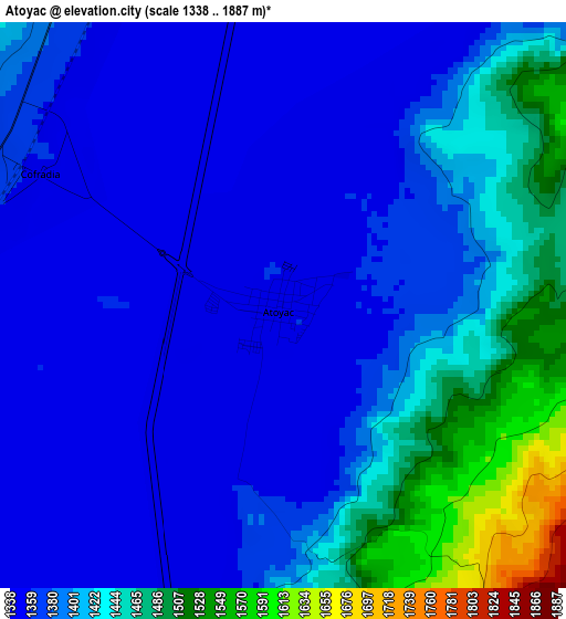
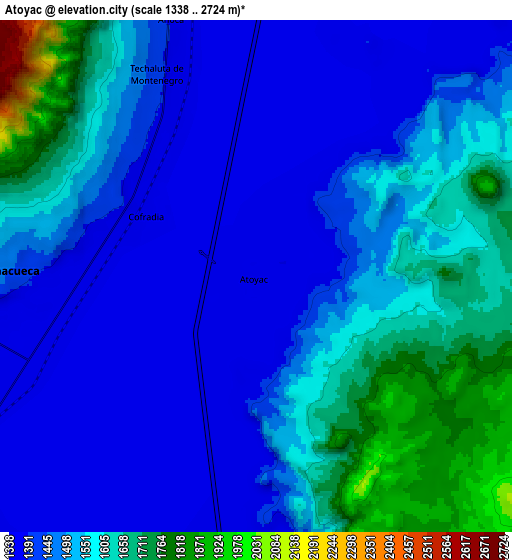
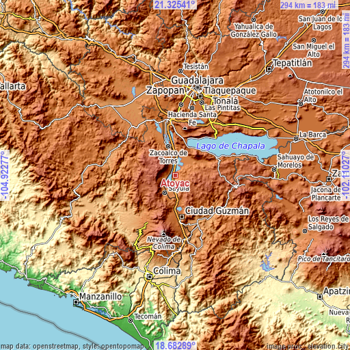
Below is the Elevation map of Atoyac, which displays elevation range with different colors. Scale of the first map is from 1338 to 1887 m (4390 to 6191 ft) with average elevation of 1399.6 meters (=4592 ft) [note 1]
These maps also provides idea of topography and contour of this city, they are displayed at different zoom levels. More info about maps, scale and edge coordinates you can find below images.
| \ | Map #1 | Map #2 | Topo.Map |
| Scale [m] | 1338..1887 m | 1338..2724 m | × |
| Scale [ft] | 4390..6191 ft | 4390..8937 ft | × |
| Average | 1399.6 m = 4592 ft | 1506.9 m = 4944 ft | × |
| Width | 9.18 km = 5.7 mi | 18.37 km = 11.4 mi | 293.8 km = 182.6 mi |
| Height | 9.18 km = 5.7 mi | 18.37 km = 11.4 mi | 293.8 km = 182.6 mi |
| ↑Max Latitude | 20.050987° | 20.092263° | 21.32541° |
| Latitude at center | 20.0097° | 20.0097° | 20.0097° |
| ↓Min Latitude | 19.968402° | 19.927093° | 18.68289° |
| ← Min Longitude | -103.560465° | -103.604411° | -104.92277° |
| Longitude center | -103.51652° | -103.51652° | -103.51652° |
| →Max Longitude | -103.472575° | -103.428629° | -102.11027° |
Nearby cities:
Cities around Atoyac sort by population:
• Sayula elevation 1373 m
16.7 km,  211°
211°
• Zacoalco de Torres 1361 m
24.9 km,  347°
347°
• Usmajac 1364 m
15.2 km,  189°
189°
• San Sebastián del Sur 1522 m
24.4 km,  169°
169°
• San Andrés Ixtlán 1546 m
21.7 km, 166°
• Teocuitatlán de Corona 1380 m
17.1 km,  57°
57°
• Juanacatlán 2518 m
17.9 km,  278°
278°
• Amacueca 1433 m
8.7 km,  270°
270°
• Techaluta de Montenegro 1413 m
7.9 km,  332°
332°
• Tepec 1600 m
13.2 km,  260°
260°
• Atacco 2045 m
25.4 km,  248°
248°
• Gómez Farías 1516 m
24.4 km, 170°
Multilingual:
 En español:
Atoyac elevación 1356 m.
 En France:
Atoyac élévation 1356 m.


Sources and notes:
- [note 1] Map square and city borders are not equal. Map elevation data is calculated only from area inside that square.
- [src 1] Elevation data from geonames database provided with same terms of usage.
- [src 2] The elevation map of Atoyac is generated using elevation data from NASA's 3 arcsec (90m) resolution SRTM data.
- [src 3] Base (background) map © OpenStreetMap contributors tiles are generated by Geofabrik and OpenTopoMap.
Copyright & License:
This Atoyac Elevation Map is licensed under CC BY-SA. You may reuse any part from this page, if you give a proper credit by linking to this URL:
 More info on terms of use page.