Cañitas de Felipe Pescador elevation
Cañitas de Felipe Pescador (Zacatecas), Mexico elevation is 2019 meters and Cañitas de Felipe Pescador elevation in feet is 6624 ft above sea level [src 1]. Cañitas de Felipe Pescador is a seat of a second-order administrative division (feature code) with elevation that is 705 meters (2313 ft) bigger than average city elevation in Mexico.
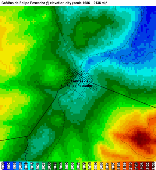
Below is the Elevation map of Cañitas de Felipe Pescador, which displays elevation range with different colors. Scale of the first map is from 1986 to 2138 m (6516 to 7014 ft) with average elevation of 2043.9 meters (=6706 ft) [note 1]
These maps also provides idea of topography and contour of this city, they are displayed at different zoom levels. More info about maps, scale and edge coordinates you can find below images.
| \ | Map #1 | Map #2 | Topo.Map |
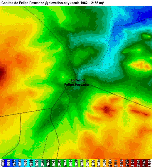
| Scale [m] | 1986..2138 m | 1962..2156 m | × |
| Scale [ft] | 6516..7014 ft | 6437..7073 ft | × |
| Average | 2043.9 m = 6706 ft | 2057 m = 6749 ft | × |
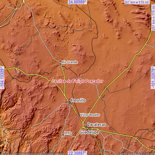
| Width | 8.95 km = 5.6 mi | 17.91 km = 11.1 mi | 286.5 km = 178 mi |
| Height | 8.95 km = 5.6 mi | 17.91 km = 11.1 mi | 286.6 km = 178.1 mi |
| ↑Max Latitude | 23.643973° | 23.684223° | 24.88589° |
| Latitude at center | 23.60371° | 23.60371° | 23.60371° |
| ↓Min Latitude | 23.563435° | 23.523148° | 22.30887° |
| ← Min Longitude | -102.770985° | -102.814931° | -104.13329° |
| Longitude center | -102.72704° | -102.72704° | -102.72704° |
| →Max Longitude | -102.683095° | -102.639149° | -101.32079° |
Nearby cities:
Cities around Cañitas de Felipe Pescador sort by population:
• Río Grande elevation 1870 m
39.6 km,  308°
308°
• Río Florido 2034 m
39.4 km,  222°
222°
• Lázaro Cárdenas (Rancho Grande) 2022 m
29.4 km,  234°
234°
• Loreto 1863 m
39.8 km, 313°
• Los Ramírez 1868 m
41.2 km, 310°
• Rio de Medina 2001 m
31.7 km,  249°
249°
• Rafael Yáñez Sosa (El Mezquite) 2093 m
32.9 km,  158°
158°
• Tetillas 2025 m
22.2 km,  303°
303°
• Altamira 2029 m
36.2 km, 227°
• José María Morelos (Santa Mónica) 1965 m
39 km,  270°
270°
• El Cazadero 1939 m
41 km,  280°
280°
• Pastelera 1914 m
40.8 km,  292°
292°
Multilingual:
 En español:
Cañitas de Felipe Pescador elevación 2019 m.
 En France:
Cañitas de Felipe Pescador élévation 2019 m.
 Auf Deutsch:
Cañitas de Felipe Pescador höhe über dem Meeresspiegel ist 2019 m.
 На русском:
Cañitas de Felipe Pescador высота над уровнем моря 2019 м
Sources and notes:
- [note 1] Map square and city borders are not equal. Map elevation data is calculated only from area inside that square.
- [src 1] Elevation data from geonames database provided with same terms of usage.
- [src 2] The elevation map of Cañitas de Felipe Pescador is generated using elevation data from NASA's 3 arcsec (90m) resolution SRTM data.
- [src 3] Base (background) map © OpenStreetMap contributors tiles are generated by Geofabrik and OpenTopoMap.
Copyright & License:
This Cañitas de Felipe Pescador Elevation Map is licensed under CC BY-SA. You may reuse any part from this page, if you give a proper credit by linking to this URL:
 More info on terms of use page.