Capula elevation
Capula (Michoacán, Nahuatzen), Mexico elevation is 2725 meters and Capula elevation in feet is 8940 ft above sea level [src 1]. Capula is a populated place (feature code) with elevation that is 1411 meters (4629 ft) bigger than average city elevation in Mexico.
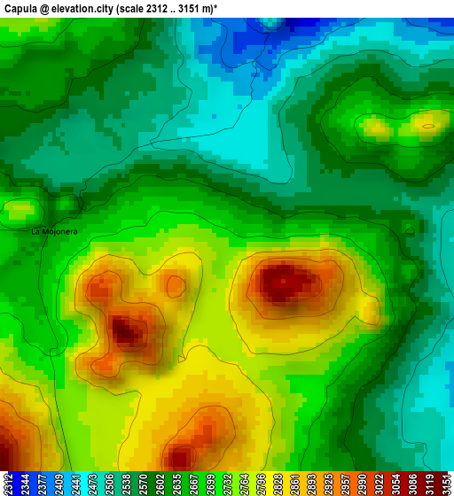
Below is the Elevation map of Capula, which displays elevation range with different colors. Scale of the first map is from 2312 to 3151 m (7585 to 10338 ft) with average elevation of 2665.2 meters (=8744 ft) [note 1]
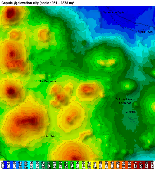
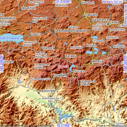
These maps also provides idea of topography and contour of this city, they are displayed at different zoom levels. More info about maps, scale and edge coordinates you can find below images.
| \ | Map #1 | Map #2 | Topo.Map |
| Scale [m] | 2312..3151 m | 1981..3378 m | × |
| Scale [ft] | 7585..10338 ft | 6499..11083 ft | × |
| Average | 2665.2 m = 8744 ft | 2597.2 m = 8521 ft | × |
| Width | 9.2 km = 5.7 mi | 18.4 km = 11.4 mi | 294.4 km = 182.9 mi |
| Height | 9.2 km = 5.7 mi | 18.4 km = 11.4 mi | 294.4 km = 182.9 mi |
| ↑Max Latitude | 19.741368° | 19.782725° | 21.01836° |
| Latitude at center | 19.7° | 19.7° | 19.7° |
| ↓Min Latitude | 19.658621° | 19.617232° | 18.37068° |
| ← Min Longitude | -101.843945° | -101.887891° | -103.20625° |
| Longitude center | -101.8° | -101.8° | -101.8° |
| →Max Longitude | -101.756055° | -101.712109° | -100.39375° |
Nearby cities:
Cities around Capula sort by population:
• Zacapu elevation 1988 m
13.6 km,  4°
4°
• Zacapú 1993 m
12.7 km, 3°
• Nahuatzén 2415 m
13.2 km,  247°
247°
• Pichátaro 2399 m
14.2 km,  183°
183°
• Sevina 2401 m
13.2 km,  233°
233°
• Tiríndaro 1995 m
9.9 km,  36°
36°
• Naranja de Tapia 1991 m
9.6 km,  26°
26°
• Erongarícuaro 2080 m
14.9 km,  146°
146°
• Santiago Azajo 2264 m
11.9 km,  86°
86°
• Tarejero 2004 m
15.9 km, 33°
• Comanjá 2083 m
12.6 km,  65°
65°
• La Mojonera 2635 m
3.5 km,  276°
276°
Multilingual:
 En español:
Capula elevación 2725 m.
 En France:
Capula élévation 2725 m.


Sources and notes:
- [note 1] Map square and city borders are not equal. Map elevation data is calculated only from area inside that square.
- [src 1] Elevation data from geonames database provided with same terms of usage.
- [src 2] The elevation map of Capula is generated using elevation data from NASA's 3 arcsec (90m) resolution SRTM data.
- [src 3] Base (background) map © OpenStreetMap contributors tiles are generated by Geofabrik and OpenTopoMap.
Copyright & License:
This Capula Elevation Map is licensed under CC BY-SA. You may reuse any part from this page, if you give a proper credit by linking to this URL:
 More info on terms of use page.