Pichátaro elevation
Pichátaro (Michoacán, Tingambato), Mexico elevation is 2399 meters and Pichátaro elevation in feet is 7871 ft above sea level [src 1]. Pichátaro is a populated place (feature code) with elevation that is 1085 meters (3560 ft) bigger than average city elevation in Mexico.
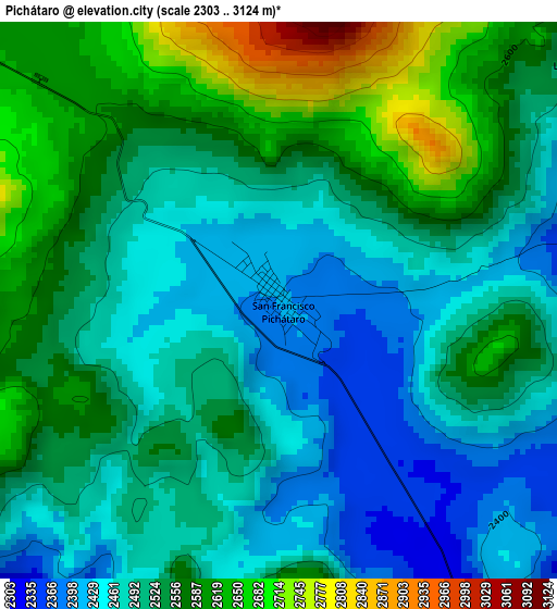
Below is the Elevation map of Pichátaro, which displays elevation range with different colors. Scale of the first map is from 2303 to 3124 m (7556 to 10249 ft) with average elevation of 2522.4 meters (=8276 ft) [note 1]
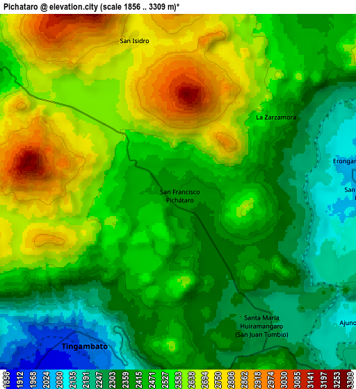
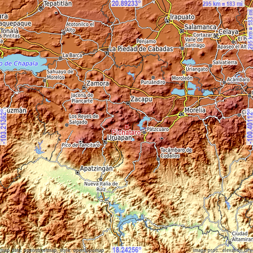
These maps also provides idea of topography and contour of this city, they are displayed at different zoom levels. More info about maps, scale and edge coordinates you can find below images.
| \ | Map #1 | Map #2 | Topo.Map |
| Scale [m] | 2303..3124 m | 1856..3309 m | × |
| Scale [ft] | 7556..10249 ft | 6089..10856 ft | × |
| Average | 2522.4 m = 8276 ft | 2483.9 m = 8149 ft | × |
| Width | 9.21 km = 5.7 mi | 18.42 km = 11.4 mi | 294.6 km = 183.1 mi |
| Height | 9.21 km = 5.7 mi | 18.42 km = 11.4 mi | 294.6 km = 183.1 mi |
| ↑Max Latitude | 19.614291° | 19.655681° | 20.89233° |
| Latitude at center | 19.57289° | 19.57289° | 19.57289° |
| ↓Min Latitude | 19.531479° | 19.490057° | 18.24256° |
| ← Min Longitude | -101.851315° | -101.895261° | -103.21362° |
| Longitude center | -101.80737° | -101.80737° | -101.80737° |
| →Max Longitude | -101.763425° | -101.719479° | -100.40112° |
Nearby cities:
Cities around Pichátaro sort by population:
• Nahuatzén elevation 2415 m
14.7 km,  308°
308°
• Tingambato 1978 m
9.3 km,  211°
211°
• Comachuén 2616 m
10.2 km,  269°
269°
• Capula 2725 m
14.2 km,  3°
3°
• Turícuaro 2361 m
13.6 km, 269°
• Sevina 2401 m
11.6 km,  302°
302°
• Jarácuaro 2069 m
13.6 km,  95°
95°
• Santa María Huiramangaro (San Juan Tumbio) 2259 m
8 km,  146°
146°
• Erongarícuaro 2080 m
9.2 km,  78°
78°
• Uricho 2057 m
9.6 km,  91°
91°
• Puácuaro 2073 m
14.3 km, 76°
• Ajuno 2101 m
11.1 km,  127°
127°
Multilingual:
 En español:
San Francisco Pichátaro elevación 2399 m.
 En France:
Pichátaro élévation 2399 m.
 Auf Deutsch:
Pichátaro höhe über dem Meeresspiegel ist 2399 m.

Sources and notes:
- [note 1] Map square and city borders are not equal. Map elevation data is calculated only from area inside that square.
- [src 1] Elevation data from geonames database provided with same terms of usage.
- [src 2] The elevation map of Pichátaro is generated using elevation data from NASA's 3 arcsec (90m) resolution SRTM data.
- [src 3] Base (background) map © OpenStreetMap contributors tiles are generated by Geofabrik and OpenTopoMap.
Copyright & License:
This Pichátaro Elevation Map is licensed under CC BY-SA. You may reuse any part from this page, if you give a proper credit by linking to this URL:
 More info on terms of use page.