Celaya elevation
Celaya (Guanajuato), Mexico elevation is 1762 meters and Celaya elevation in feet is 5781 ft above sea level [src 1]. Celaya is a seat of a second-order administrative division (feature code) with elevation that is 448 meters (1470 ft) bigger than average city elevation in Mexico.
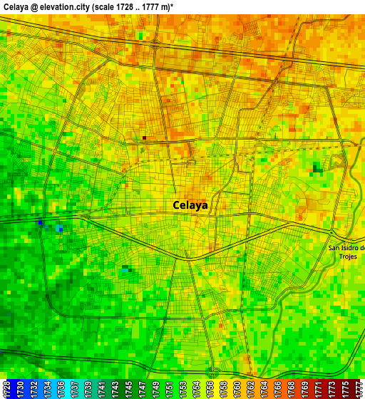
Below is the Elevation map of Celaya, which displays elevation range with different colors. Scale of the first map is from 1728 to 1777 m (5669 to 5830 ft) with average elevation of 1755.6 meters (=5760 ft) [note 1]
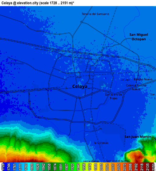
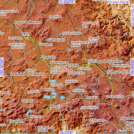
These maps also provides idea of topography and contour of this city, they are displayed at different zoom levels. More info about maps, scale and edge coordinates you can find below images.
| \ | Map #1 | Map #2 | Topo.Map |
| Scale [m] | 1728..1777 m | 1728..2151 m | × |
| Scale [ft] | 5669..5830 ft | 5669..7057 ft | × |
| Average | 1755.6 m = 5760 ft | 1776.4 m = 5828 ft | × |
| Width | 9.15 km = 5.7 mi | 18.3 km = 11.4 mi | 292.8 km = 181.9 mi |
| Height | 9.15 km = 5.7 mi | 18.3 km = 11.4 mi | 292.9 km = 182 mi |
| ↑Max Latitude | 20.56468° | 20.60582° | 21.83476° |
| Latitude at center | 20.52353° | 20.52353° | 20.52353° |
| ↓Min Latitude | 20.482368° | 20.441196° | 19.20097° |
| ← Min Longitude | -100.859645° | -100.903591° | -102.22195° |
| Longitude center | -100.8157° | -100.8157° | -100.8157° |
| →Max Longitude | -100.771755° | -100.727809° | -99.40945° |
Nearby cities:
Cities around Celaya sort by population:
• Roque elevation 1764 m
6.9 km,  341°
341°
• Primera Fracción de Crespo 1750 m
4.8 km,  231°
231°
• La Laja 1758 m
5.7 km,  83°
83°
• Plancarte 1768 m
7.3 km,  16°
16°
• Estrada 1750 m
5.2 km,  276°
276°
• Colonia Pedro María Anaya 1750 m
6.5 km,  272°
272°
• Santa Anita 1755 m
5.9 km,  179°
179°
• Los Mancera 1756 m
6 km,  168°
168°
• El Puesto 1755 m
6.2 km,  191°
191°
• Colonia Patria Nueva 1750 m
6.7 km, 274°
• La Palmita (La Palmita de San Gabriel) 1747 m
7.1 km,  246°
246°
• La Trinidad 1764 m
5.5 km,  37°
37°
Multilingual:
 En español:
Celaya elevación 1762 m.
 En France:
Celaya élévation 1762 m.


Sources and notes:
- [note 1] Map square and city borders are not equal. Map elevation data is calculated only from area inside that square.
- [src 1] Elevation data from geonames database provided with same terms of usage.
- [src 2] The elevation map of Celaya is generated using elevation data from NASA's 3 arcsec (90m) resolution SRTM data.
- [src 3] Base (background) map © OpenStreetMap contributors tiles are generated by Geofabrik and OpenTopoMap.
Copyright & License:
This Celaya Elevation Map is licensed under CC BY-SA. You may reuse any part from this page, if you give a proper credit by linking to this URL:
 More info on terms of use page.