Estrada elevation
Estrada (Guanajuato, Celaya), Mexico elevation is 1750 meters and Estrada elevation in feet is 5741 ft above sea level [src 1]. Estrada is a populated place (feature code) with elevation that is 436 meters (1430 ft) bigger than average city elevation in Mexico.
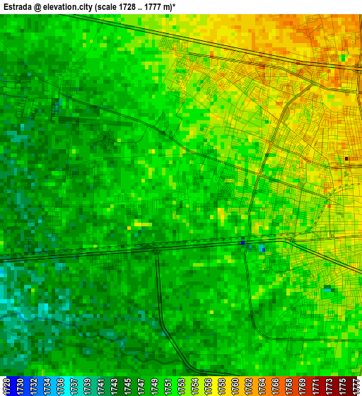
Below is the Elevation map of Estrada, which displays elevation range with different colors. Scale of the first map is from 1728 to 1777 m (5669 to 5830 ft) with average elevation of 1750.4 meters (=5743 ft) [note 1]
These maps also provides idea of topography and contour of this city, they are displayed at different zoom levels. More info about maps, scale and edge coordinates you can find below images.
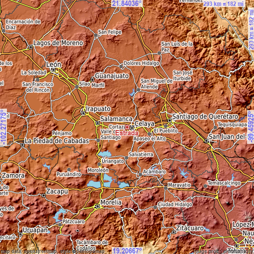
| \ | Map #1 | Topo.Map |
| Scale [m] | 1728..1777 m | × |
| Scale [ft] | 5669..5830 ft | × |
| Average | 1750.4 m = 5743 ft | × |
| Width | 9.15 km = 5.7 mi | 292.8 km = 181.9 mi |
| Height | 9.15 km = 5.7 mi | 292.9 km = 182 mi |
| ↑Max Latitude | 20.570329° | 21.84036° |
| Latitude at center | 20.52918° | 20.52918° |
| ↓Min Latitude | 20.48802° | 19.20667° |
| ← Min Longitude | -100.909445° | -102.27175° |
| Longitude center | -100.8655° | -100.8655° |
| →Max Longitude | -100.821555° | -99.45925° |
Nearby cities:
Cities around Estrada sort by population:
• Celaya elevation 1762 m
5.2 km,  96°
96°
• Roque 1764 m
6.6 km,  26°
26°
• Primera Fracción de Crespo 1750 m
3.9 km,  158°
158°
• San José de Guanajuato 1749 m
4.1 km,  316°
316°
• Yustis 1758 m
5.9 km,  1°
1°
• Colonia Pedro María Anaya 1750 m
1.3 km,  255°
255°
• El Chinaco (El Pujido) 1742 m
5.7 km, 262°
• Colonia Patria Nueva 1750 m
1.5 km,  266°
266°
• La Palmita (La Palmita de San Gabriel) 1747 m
3.7 km,  200°
200°
• Colonia Fraccionamiento el Puente 1748 m
3.3 km, 259°
• Merino 1746 m
4.3 km,  206°
206°
• Santa Fe de la Purísima 1747 m
4.7 km,  217°
217°
Multilingual:
 En español:
Estrada elevación 1750 m.
 En France:
Estrada élévation 1750 m.
 Auf Deutsch:
Estrada höhe über dem Meeresspiegel ist 1750 m.

Sources and notes:
- [note 1] Map square and city borders are not equal. Map elevation data is calculated only from area inside that square.
- [src 1] Elevation data from geonames database provided with same terms of usage.
- [src 2] The elevation map of Estrada is generated using elevation data from NASA's 3 arcsec (90m) resolution SRTM data.
- [src 3] Base (background) map © OpenStreetMap contributors tiles are generated by Geofabrik and OpenTopoMap.
Copyright & License:
This Estrada Elevation Map is licensed under CC BY-SA. You may reuse any part from this page, if you give a proper credit by linking to this URL:
 More info on terms of use page.