Cherán elevation
Cherán (Michoacán), Mexico elevation is 2395 meters and Cherán elevation in feet is 7858 ft above sea level [src 1]. Cherán is a seat of a second-order administrative division (feature code) with elevation that is 1081 meters (3547 ft) bigger than average city elevation in Mexico.
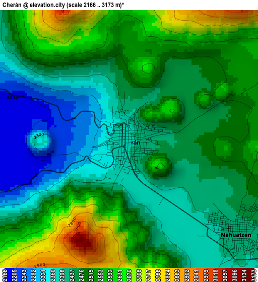
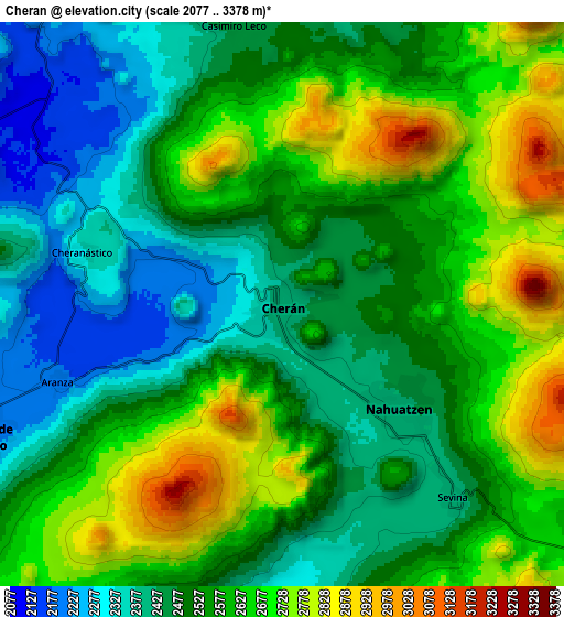
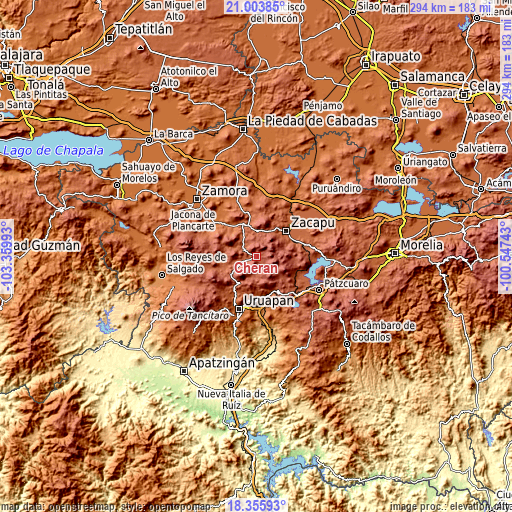
Below is the Elevation map of Cherán, which displays elevation range with different colors. Scale of the first map is from 2166 to 3173 m (7106 to 10410 ft) with average elevation of 2487.3 meters (=8160 ft) [note 1]
These maps also provides idea of topography and contour of this city, they are displayed at different zoom levels. More info about maps, scale and edge coordinates you can find below images.
| \ | Map #1 | Map #2 | Topo.Map |
| Scale [m] | 2166..3173 m | 2077..3378 m | × |
| Scale [ft] | 7106..10410 ft | 6814..11083 ft | × |
| Average | 2487.3 m = 8160 ft | 2554.6 m = 8381 ft | × |
| Width | 9.2 km = 5.7 mi | 18.4 km = 11.4 mi | 294.4 km = 182.9 mi |
| Height | 9.2 km = 5.7 mi | 18.4 km = 11.4 mi | 294.4 km = 182.9 mi |
| ↑Max Latitude | 19.726732° | 19.768093° | 21.00385° |
| Latitude at center | 19.68536° | 19.68536° | 19.68536° |
| ↓Min Latitude | 19.643978° | 19.602585° | 18.35593° |
| ← Min Longitude | -101.997625° | -102.041571° | -103.35993° |
| Longitude center | -101.95368° | -101.95368° | -101.95368° |
| →Max Longitude | -101.909735° | -101.865789° | -100.54743° |
Nearby cities:
Cities around Cherán sort by population:
• Paracho de Verduzco elevation 2226 m
10.8 km,  247°
247°
• Nahuatzén 2415 m
5.1 km,  131°
131°
• Comachuén 2616 m
13.7 km,  157°
157°
• Turícuaro 2361 m
12.8 km,  172°
172°
• Sevina 2401 m
8.4 km,  138°
138°
• Tanaco 2195 m
14.7 km,  294°
294°
• Arantepacua 2318 m
10.1 km,  188°
188°
• Quinceo 2509 m
11.2 km,  205°
205°
• Cherán Atzicuirín (Cheranástico) 2327 m
6.7 km,  284°
284°
• Ahuirán 2263 m
12.7 km,  260°
260°
• Aranza 2192 m
7.7 km, 252°
• La Mojonera 2635 m
12.8 km,  80°
80°
Multilingual:
 En español:
Cherán elevación 2395 m.
 En France:
Cherán élévation 2395 m.


Sources and notes:
- [note 1] Map square and city borders are not equal. Map elevation data is calculated only from area inside that square.
- [src 1] Elevation data from geonames database provided with same terms of usage.
- [src 2] The elevation map of Cherán is generated using elevation data from NASA's 3 arcsec (90m) resolution SRTM data.
- [src 3] Base (background) map © OpenStreetMap contributors tiles are generated by Geofabrik and OpenTopoMap.
Copyright & License:
This Cherán Elevation Map is licensed under CC BY-SA. You may reuse any part from this page, if you give a proper credit by linking to this URL:
 More info on terms of use page.