Tanaco elevation
Tanaco (Michoacán, Cherán), Mexico elevation is 2195 meters and Tanaco elevation in feet is 7201 ft above sea level [src 1]. Tanaco is a populated place (feature code) with elevation that is 881 meters (2890 ft) bigger than average city elevation in Mexico.
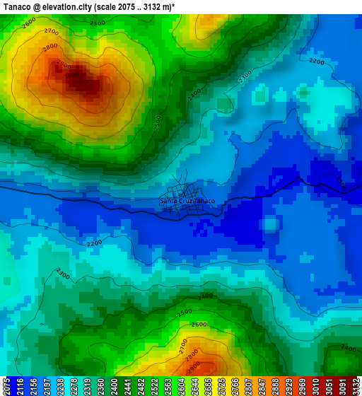
Below is the Elevation map of Tanaco, which displays elevation range with different colors. Scale of the first map is from 2075 to 3132 m (6808 to 10276 ft) with average elevation of 2365.2 meters (=7760 ft) [note 1]
These maps also provides idea of topography and contour of this city, they are displayed at different zoom levels. More info about maps, scale and edge coordinates you can find below images.
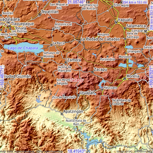
| \ | Map #1 | Topo.Map |
| Scale [m] | 2075..3132 m | × |
| Scale [ft] | 6808..10276 ft | × |
| Average | 2365.2 m = 7760 ft | × |
| Width | 9.2 km = 5.7 mi | 294.3 km = 182.9 mi |
| Height | 9.2 km = 5.7 mi | 294.3 km = 182.9 mi |
| ↑Max Latitude | 19.780788° | 21.05746° |
| Latitude at center | 19.73943° | 19.73943° |
| ↓Min Latitude | 19.698062° | 18.41043° |
| ← Min Longitude | -102.125405° | -103.48771° |
| Longitude center | -102.08146° | -102.08146° |
| →Max Longitude | -102.037515° | -100.67521° |
Nearby cities:
Cities around Tanaco sort by population:
• Paracho de Verduzco elevation 2226 m
10.8 km,  161°
161°
• Nurío 2182 m
10.5 km,  208°
208°
• Huancito 1839 m
12.3 km,  6°
6°
• Zopoco 1835 m
11.2 km,  3°
3°
• Acachuén 1800 m
12 km,  354°
354°
• Cherán Atzicuirín (Cheranástico) 2327 m
8.2 km,  122°
122°
• Ahuirán 2263 m
8.2 km,  174°
174°
• Aranza 2192 m
10.3 km,  144°
144°
• Santa María Urapicho 2314 m
7.2 km, 206°
• Tanaquillo 1789 m
12 km, 351°
• Urén 1784 m
12.1 km, 348°
• Santo Tomás 1814 m
11.8 km,  357°
357°
Multilingual:
 En español:
Tanaco elevación 2195 m.
 En France:
Tanaco élévation 2195 m.


Sources and notes:
- [note 1] Map square and city borders are not equal. Map elevation data is calculated only from area inside that square.
- [src 1] Elevation data from geonames database provided with same terms of usage.
- [src 2] The elevation map of Tanaco is generated using elevation data from NASA's 3 arcsec (90m) resolution SRTM data.
- [src 3] Base (background) map © OpenStreetMap contributors tiles are generated by Geofabrik and OpenTopoMap.
Copyright & License:
This Tanaco Elevation Map is licensed under CC BY-SA. You may reuse any part from this page, if you give a proper credit by linking to this URL:
 More info on terms of use page.