Chucándiro elevation
Chucándiro (Michoacán), Mexico elevation is 1861 meters and Chucándiro elevation in feet is 6106 ft above sea level [src 1]. Chucándiro is a seat of a second-order administrative division (feature code) with elevation that is 547 meters (1795 ft) bigger than average city elevation in Mexico.
Below is the Elevation map of Chucándiro, which displays elevation range with different colors. Scale of the first map is from 1831 to 2454 m (6007 to 8051 ft) with average elevation of 2001.4 meters (=6566 ft) [note 1]
These maps also provides idea of topography and contour of this city, they are displayed at different zoom levels. More info about maps, scale and edge coordinates you can find below images.
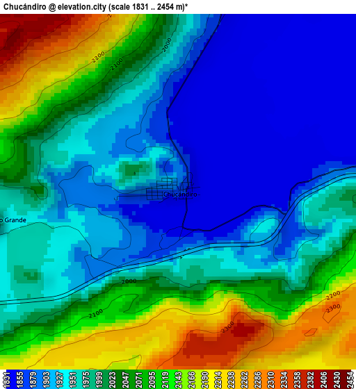
| \ | Map #1 | Topo.Map |
| Scale [m] | 1831..2454 m | × |
| Scale [ft] | 6007..8051 ft | × |
| Average | 2001.4 m = 6566 ft | × |
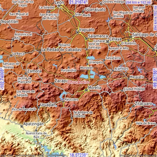
| Width | 9.19 km = 5.7 mi | 294 km = 182.7 mi |
| Height | 9.19 km = 5.7 mi | 294 km = 182.7 mi |
| ↑Max Latitude | 19.941396° | 21.21674° |
| Latitude at center | 19.90008° | 19.90008° |
| ↓Min Latitude | 19.858753° | 18.57238° |
| ← Min Longitude | -101.377745° | -102.74005° |
| Longitude center | -101.3338° | -101.3338° |
| →Max Longitude | -101.289855° | -99.92755° |
Nearby cities:
Cities around Chucándiro sort by population:
• Huandacareo elevation 1855 m
11.8 km,  30°
30°
• Copándaro de Galeana 1849 m
12.6 km,  93°
93°
• Huaniqueo de Morales 2049 m
17.9 km,  268°
268°
• Villa Morelos 2290 m
14.2 km,  324°
324°
• Capacho 1847 m
12.9 km,  56°
56°
• San Agustín del Maíz 1842 m
17.7 km, 90°
• San José Cuaro 1861 m
13 km,  41°
41°
• Chiquimitío 2043 m
14.5 km,  143°
143°
• Ex-Hacienda de Guadalupe 1914 m
17.9 km, 135°
• Piñícuaro 2109 m
19 km, 30°
• Cuto de la Esperanza 2155 m
18.8 km,  182°
182°
• Doctor Miguel Silva (San Guillermo) 1848 m
18.2 km,  66°
66°
Multilingual:
 En español:
Chucándiro elevación 1861 m.
 En France:
Chucándiro élévation 1861 m.
 Auf Deutsch:
Chucándiro höhe über dem Meeresspiegel ist 1861 m.

Sources and notes:
- [note 1] Map square and city borders are not equal. Map elevation data is calculated only from area inside that square.
- [src 1] Elevation data from geonames database provided with same terms of usage.
- [src 2] The elevation map of Chucándiro is generated using elevation data from NASA's 3 arcsec (90m) resolution SRTM data.
- [src 3] Base (background) map © OpenStreetMap contributors tiles are generated by Geofabrik and OpenTopoMap.
Copyright & License:
This Chucándiro Elevation Map is licensed under CC BY-SA. You may reuse any part from this page, if you give a proper credit by linking to this URL:
 More info on terms of use page.