Ciudad Acuña elevation
Ciudad Acuña (Coahuila, Acuña), Mexico elevation is 283 meters and Ciudad Acuña elevation in feet is 928 ft above sea level [src 1]. Ciudad Acuña is a populated place (feature code) with elevation that is 1031 meters (3383 ft) smaller than average city elevation in Mexico.
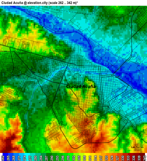
Below is the Elevation map of Ciudad Acuña, which displays elevation range with different colors. Scale of the first map is from 262 to 342 m (860 to 1122 ft) with average elevation of 290.5 meters (=953 ft) [note 1]
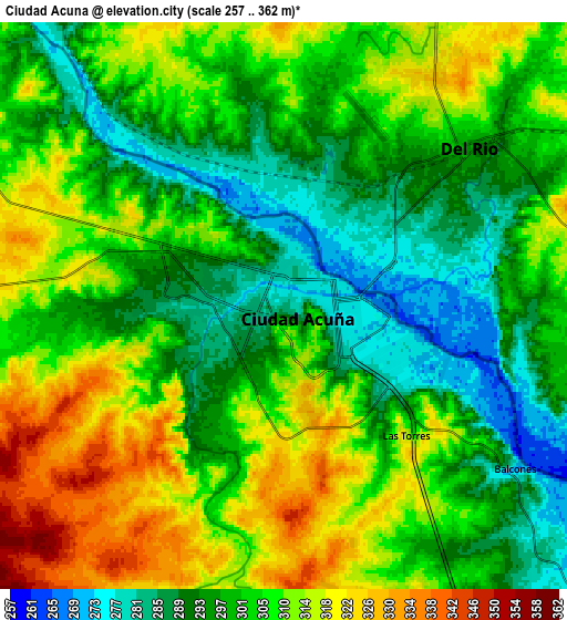
These maps also provides idea of topography and contour of this city, they are displayed at different zoom levels. More info about maps, scale and edge coordinates you can find below images.
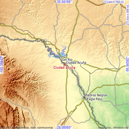
| \ | Map #1 | Map #2 | Topo.Map |
| Scale [m] | 262..342 m | 257..362 m | × |
| Scale [ft] | 860..1122 ft | 843..1188 ft | × |
| Average | 290.5 m = 953 ft | 303.3 m = 995 ft | × |
| Width | 8.52 km = 5.3 mi | 17.04 km = 10.6 mi | 272.6 km = 169.4 mi |
| Height | 8.52 km = 5.3 mi | 17.04 km = 10.6 mi | 272.6 km = 169.4 mi |
| ↑Max Latitude | 29.361527° | 29.39982° | 30.54186° |
| Latitude at center | 29.32322° | 29.32322° | 29.32322° |
| ↓Min Latitude | 29.284898° | 29.246562° | 28.08985° |
| ← Min Longitude | -100.996115° | -101.040061° | -102.35842° |
| Longitude center | -100.95217° | -100.95217° | -100.95217° |
| →Max Longitude | -100.908225° | -100.864279° | -99.54592° |
Nearby cities:
Cities around Ciudad Acuña sort by population:
• Piedras Negras elevation 223 m
80.9 km,  148°
148°
• Nava 329 m
102 km,  169°
169°
• Allende 385 m
109.6 km, 174°
• Zaragoza 362 m
92.3 km,  178°
178°
• Morelos 374 m
102.1 km, 176°
• Villa Unión 385 m
124.4 km, 169°
• Villa Union 381 m
125.2 km, 169°
• Colonia Venustiano Carranza 258 m
85.3 km, 153°
• San Carlos 330 m
33.1 km, 171°
• Río Bravo 413 m
112.4 km, 178°
• Jiménez 255 m
38.7 km,  136°
136°
• Los Álamos 408 m
107.5 km, 179°
Multilingual:
 En español:
Acuña elevación 283 m.
 En France:
Ciudad Acuña élévation 283 m.
 Auf Deutsch:
Ciudad Acuña höhe über dem Meeresspiegel ist 283 m.

Sources and notes:
- [note 1] Map square and city borders are not equal. Map elevation data is calculated only from area inside that square.
- [src 1] Elevation data from geonames database provided with same terms of usage.
- [src 2] The elevation map of Ciudad Acuña is generated using elevation data from NASA's 3 arcsec (90m) resolution SRTM data.
- [src 3] Base (background) map © OpenStreetMap contributors tiles are generated by Geofabrik and OpenTopoMap.
Copyright & License:
This Ciudad Acuña Elevation Map is licensed under CC BY-SA. You may reuse any part from this page, if you give a proper credit by linking to this URL:
 More info on terms of use page.