Río Bravo elevation
Río Bravo (Coahuila, Allende), Mexico elevation is 413 meters and Río Bravo elevation in feet is 1355 ft above sea level [src 1]. Río Bravo is a populated place (feature code) with elevation that is 901 meters (2956 ft) smaller than average city elevation in Mexico.
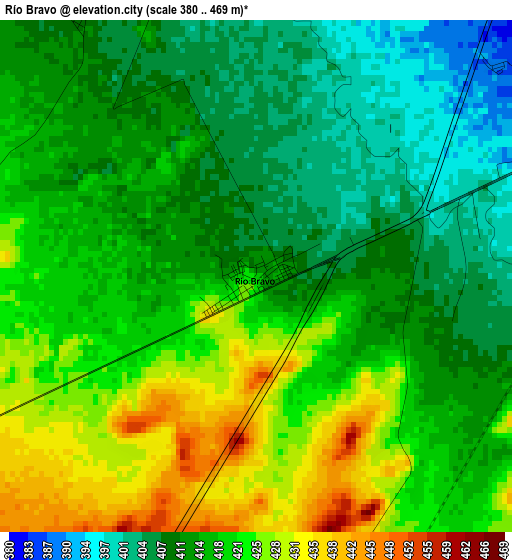
Below is the Elevation map of Río Bravo, which displays elevation range with different colors. Scale of the first map is from 380 to 469 m (1247 to 1539 ft) with average elevation of 416.5 meters (=1366 ft) [note 1]
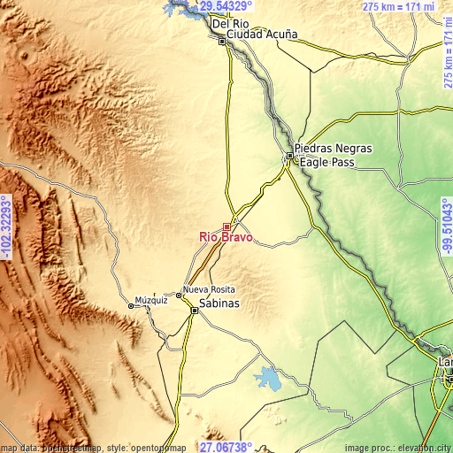
These maps also provides idea of topography and contour of this city, they are displayed at different zoom levels. More info about maps, scale and edge coordinates you can find below images.
| \ | Map #1 | Topo.Map |
| Scale [m] | 380..469 m | × |
| Scale [ft] | 1247..1539 ft | × |
| Average | 416.5 m = 1366 ft | × |
| Width | 8.6 km = 5.3 mi | 275.3 km = 171.1 mi |
| Height | 8.6 km = 5.3 mi | 275.3 km = 171.1 mi |
| ↑Max Latitude | 28.351221° | 29.54329° |
| Latitude at center | 28.31254° | 28.31254° |
| ↓Min Latitude | 28.273845° | 27.06738° |
| ← Min Longitude | -100.960625° | -102.32293° |
| Longitude center | -100.91668° | -100.91668° |
| →Max Longitude | -100.872735° | -99.51043° |
Nearby cities:
Cities around Río Bravo sort by population:
• Sabinas elevation 342 m
54.5 km,  201°
201°
• Nueva Rosita 391 m
50.9 km,  215°
215°
• Nava 329 m
19.1 km,  50°
50°
• Allende 385 m
7.2 km,  63°
63°
• Zaragoza 362 m
20.1 km,  358°
358°
• Morelos 374 m
10.8 km,  14°
14°
• Villa Unión 385 m
21.2 km,  118°
118°
• Villa Union 381 m
22.3 km, 118°
• Colonia Venustiano Carranza 258 m
50.5 km,  44°
44°
• Cloete 365 m
50.4 km,  210°
210°
• Los Álamos 408 m
5.6 km,  329°
329°
• Guerrero 222 m
52.5 km,  90°
90°
Multilingual:
 En español:
Río Bravo elevación 413 m.
 En France:
Río Bravo élévation 413 m.
 Auf Deutsch:
Río Bravo höhe über dem Meeresspiegel ist 413 m.

Sources and notes:
- [note 1] Map square and city borders are not equal. Map elevation data is calculated only from area inside that square.
- [src 1] Elevation data from geonames database provided with same terms of usage.
- [src 2] The elevation map of Río Bravo is generated using elevation data from NASA's 3 arcsec (90m) resolution SRTM data.
- [src 3] Base (background) map © OpenStreetMap contributors tiles are generated by Geofabrik and OpenTopoMap.
Copyright & License:
This Río Bravo Elevation Map is licensed under CC BY-SA. You may reuse any part from this page, if you give a proper credit by linking to this URL:
 More info on terms of use page.