Comala elevation
Comala (Colima), Mexico elevation is 625 meters and Comala elevation in feet is 2051 ft above sea level [src 1]. Comala is a seat of a second-order administrative division (feature code) with elevation that is 689 meters (2260 ft) smaller than average city elevation in Mexico.
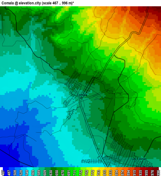
Below is the Elevation map of Comala, which displays elevation range with different colors. Scale of the first map is from 467 to 996 m (1532 to 3268 ft) with average elevation of 645.6 meters (=2118 ft) [note 1]
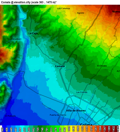
These maps also provides idea of topography and contour of this city, they are displayed at different zoom levels. More info about maps, scale and edge coordinates you can find below images.
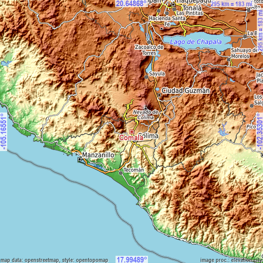
| \ | Map #1 | Map #2 | Topo.Map |
| Scale [m] | 467..996 m | 363..1475 m | × |
| Scale [ft] | 1532..3268 ft | 1191..4839 ft | × |
| Average | 645.6 m = 2118 ft | 711.6 m = 2335 ft | × |
| Width | 9.22 km = 5.7 mi | 18.44 km = 11.5 mi | 295.1 km = 183.4 mi |
| Height | 9.22 km = 5.7 mi | 18.44 km = 11.5 mi | 295.1 km = 183.4 mi |
| ↑Max Latitude | 19.368633° | 19.410086° | 20.64868° |
| Latitude at center | 19.32717° | 19.32717° | 19.32717° |
| ↓Min Latitude | 19.285696° | 19.244212° | 17.99489° |
| ← Min Longitude | -103.803205° | -103.847151° | -105.16551° |
| Longitude center | -103.75926° | -103.75926° | -103.75926° |
| →Max Longitude | -103.715315° | -103.671369° | -102.35301° |
Nearby cities:
Cities around Comala sort by population:
• Colima elevation 502 m
9.2 km,  158°
158°
• Ciudad de Villa de Álvarez 531 m
7 km, 161°
• Coquimatlán 344 m
14.4 km,  201°
201°
• Quesería 1255 m
20.7 km,  71°
71°
• Cuauhtémoc 946 m
16.4 km,  89°
89°
• Cofradía 1394 m
24.9 km,  61°
61°
• Suchitlán 1058 m
7.3 km,  43°
43°
• El Trapiche 654 m
11.7 km,  117°
117°
• Zacualpan 651 m
7.9 km,  300°
300°
• Alcaraces 1158 m
19.6 km,  77°
77°
• Cofradía de Suchitlán 1295 m
11 km,  33°
33°
• Piscila 386 m
19.7 km, 161°
Multilingual:
 En español:
Comala elevación 625 m.
 En France:
Comala élévation 625 m.


Sources and notes:
- [note 1] Map square and city borders are not equal. Map elevation data is calculated only from area inside that square.
- [src 1] Elevation data from geonames database provided with same terms of usage.
- [src 2] The elevation map of Comala is generated using elevation data from NASA's 3 arcsec (90m) resolution SRTM data.
- [src 3] Base (background) map © OpenStreetMap contributors tiles are generated by Geofabrik and OpenTopoMap.
Copyright & License:
This Comala Elevation Map is licensed under CC BY-SA. You may reuse any part from this page, if you give a proper credit by linking to this URL:
 More info on terms of use page.