Coquimatlán elevation
Coquimatlán (Colima), Mexico elevation is 344 meters and Coquimatlán elevation in feet is 1129 ft above sea level [src 1]. Coquimatlán is a seat of a second-order administrative division (feature code) with elevation that is 970 meters (3182 ft) smaller than average city elevation in Mexico.
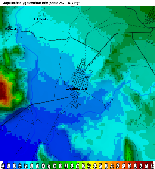
Below is the Elevation map of Coquimatlán, which displays elevation range with different colors. Scale of the first map is from 262 to 877 m (860 to 2877 ft) with average elevation of 372.4 meters (=1222 ft) [note 1]
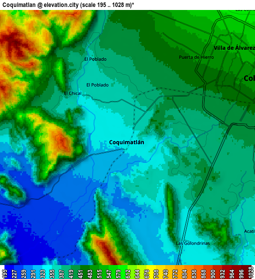
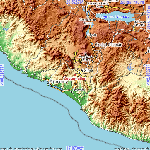
These maps also provides idea of topography and contour of this city, they are displayed at different zoom levels. More info about maps, scale and edge coordinates you can find below images.
| \ | Map #1 | Map #2 | Topo.Map |
| Scale [m] | 262..877 m | 195..1028 m | × |
| Scale [ft] | 860..2877 ft | 640..3373 ft | × |
| Average | 372.4 m = 1222 ft | 430.2 m = 1411 ft | × |
| Width | 9.23 km = 5.7 mi | 18.46 km = 11.5 mi | 295.3 km = 183.5 mi |
| Height | 9.23 km = 5.7 mi | 18.46 km = 11.5 mi | 295.3 km = 183.5 mi |
| ↑Max Latitude | 19.247744° | 19.289228° | 20.52876° |
| Latitude at center | 19.20625° | 19.20625° | 19.20625° |
| ↓Min Latitude | 19.164745° | 19.12323° | 17.87302° |
| ← Min Longitude | -103.853465° | -103.897411° | -105.21577° |
| Longitude center | -103.80952° | -103.80952° | -103.80952° |
| →Max Longitude | -103.765575° | -103.721629° | -102.40327° |
Nearby cities:
Cities around Coquimatlán sort by population:
• Colima elevation 502 m
9.9 km,  60°
60°
• Ciudad de Villa de Álvarez 531 m
10.1 km,  48°
48°
• Comala 625 m
14.4 km,  21°
21°
• Suchitlán 1058 m
21.4 km,  28°
28°
• Madrid 183 m
15 km,  205°
205°
• El Trapiche 654 m
17.5 km, 62°
• Rincón de López 126 m
21.4 km,  217°
217°
• Ixtlahuacán 167 m
24.1 km,  161°
161°
• Pueblo Juárez (La Magdalena) 271 m
13.5 km,  251°
251°
• Zacualpan 651 m
17.5 km,  354°
354°
• Los Tepames 475 m
23.3 km,  122°
122°
• Piscila 386 m
12.5 km,  114°
114°
Multilingual:
 En español:
Coquimatlán elevación 344 m.
 En France:
Coquimatlán élévation 344 m.
 Auf Deutsch:
Coquimatlán höhe über dem Meeresspiegel ist 344 m.

Sources and notes:
- [note 1] Map square and city borders are not equal. Map elevation data is calculated only from area inside that square.
- [src 1] Elevation data from geonames database provided with same terms of usage.
- [src 2] The elevation map of Coquimatlán is generated using elevation data from NASA's 3 arcsec (90m) resolution SRTM data.
- [src 3] Base (background) map © OpenStreetMap contributors tiles are generated by Geofabrik and OpenTopoMap.
Copyright & License:
This Coquimatlán Elevation Map is licensed under CC BY-SA. You may reuse any part from this page, if you give a proper credit by linking to this URL:
 More info on terms of use page.