Cotija de la Paz elevation
Cotija de la Paz (Michoacán, Cotija), Mexico elevation is 1642 meters and Cotija de la Paz elevation in feet is 5387 ft above sea level [src 1]. Cotija de la Paz is a seat of a second-order administrative division (feature code) with elevation that is 328 meters (1076 ft) bigger than average city elevation in Mexico.
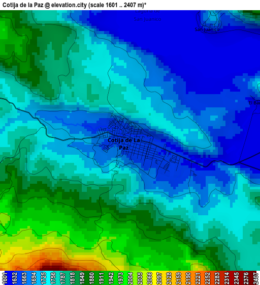
Below is the Elevation map of Cotija de la Paz, which displays elevation range with different colors. Scale of the first map is from 1601 to 2407 m (5253 to 7897 ft) with average elevation of 1767.8 meters (=5800 ft) [note 1]
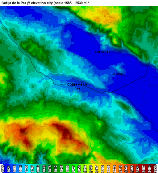
These maps also provides idea of topography and contour of this city, they are displayed at different zoom levels. More info about maps, scale and edge coordinates you can find below images.
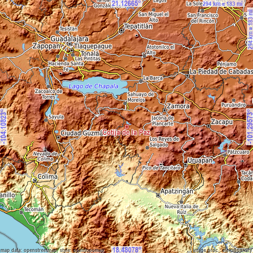
| \ | Map #1 | Map #2 | Topo.Map |
| Scale [m] | 1601..2407 m | 1585..2530 m | × |
| Scale [ft] | 5253..7897 ft | 5200..8301 ft | × |
| Average | 1767.8 m = 5800 ft | 1842.3 m = 6044 ft | × |
| Width | 9.19 km = 5.7 mi | 18.39 km = 11.4 mi | 294.2 km = 182.8 mi |
| Height | 9.19 km = 5.7 mi | 18.39 km = 11.4 mi | 294.2 km = 182.8 mi |
| ↑Max Latitude | 19.85056° | 19.891888° | 21.12665° |
| Latitude at center | 19.80922° | 19.80922° | 19.80922° |
| ↓Min Latitude | 19.76787° | 19.726509° | 18.48078° |
| ← Min Longitude | -102.745925° | -102.789871° | -104.10823° |
| Longitude center | -102.70198° | -102.70198° | -102.70198° |
| →Max Longitude | -102.658035° | -102.614089° | -101.29573° |
Nearby cities:
Cities around Cotija de la Paz sort by population:
• Jiquílpan de Juárez elevation 1552 m
20.7 km,  354°
354°
• Tingüindín 1693 m
24.4 km,  108°
108°
• Emiliano Zapata 1543 m
22.4 km,  23°
23°
• Tacátzcuaro 1619 m
18.4 km,  118°
118°
• Los Remedios 1583 m
18.9 km,  7°
7°
• Tocumbo 1610 m
22.2 km, 122°
• San Martín Totolán 1547 m
19.7 km, 6°
• San Antonio Guaracha 1607 m
21.5 km,  45°
45°
• Quitupan 1652 m
22.2 km,  306°
306°
• Lázaro Cárdenas 1628 m
16.3 km,  303°
303°
• Fraccionamiento Colinas Universidad 1655 m
23.5 km, 351°
• Los Hucuares 1836 m
23.6 km,  64°
64°
Multilingual:
 En español:
Cotija de la Paz elevación 1642 m.
 En France:
Cotija de la Paz élévation 1642 m.
 Auf Deutsch:
Cotija de la Paz höhe über dem Meeresspiegel ist 1642 m.

Sources and notes:
- [note 1] Map square and city borders are not equal. Map elevation data is calculated only from area inside that square.
- [src 1] Elevation data from geonames database provided with same terms of usage.
- [src 2] The elevation map of Cotija de la Paz is generated using elevation data from NASA's 3 arcsec (90m) resolution SRTM data.
- [src 3] Base (background) map © OpenStreetMap contributors tiles are generated by Geofabrik and OpenTopoMap.
Copyright & License:
This Cotija de la Paz Elevation Map is licensed under CC BY-SA. You may reuse any part from this page, if you give a proper credit by linking to this URL:
 More info on terms of use page.