Coyuca de Catalán elevation
Coyuca de Catalán (Guerrero), Mexico elevation is 256 meters and Coyuca de Catalán elevation in feet is 840 ft above sea level [src 1]. Coyuca de Catalán is a seat of a second-order administrative division (feature code) with elevation that is 1058 meters (3471 ft) smaller than average city elevation in Mexico.
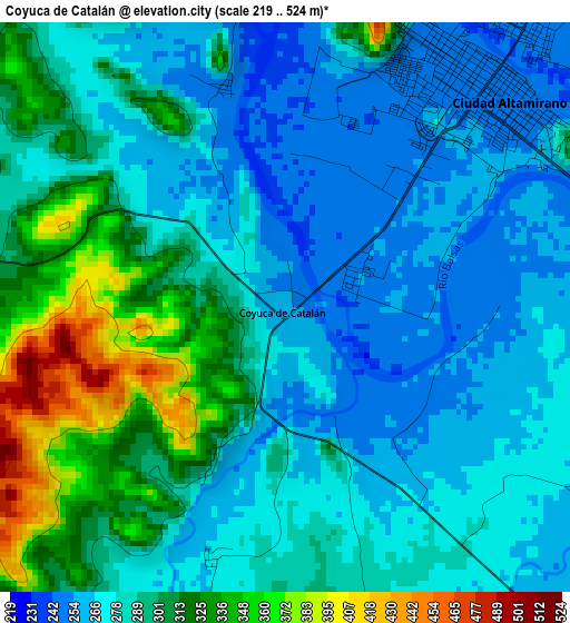
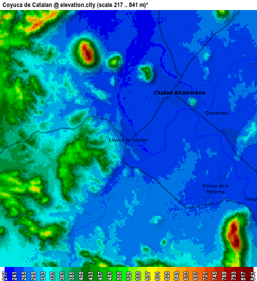
Below is the Elevation map of Coyuca de Catalán, which displays elevation range with different colors. Scale of the first map is from 219 to 524 m (719 to 1719 ft) with average elevation of 289.5 meters (=950 ft) [note 1]
These maps also provides idea of topography and contour of this city, they are displayed at different zoom levels. More info about maps, scale and edge coordinates you can find below images.
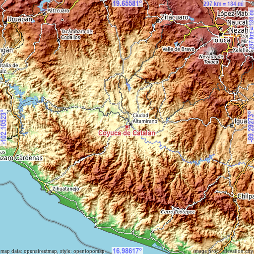
| \ | Map #1 | Map #2 | Topo.Map |
| Scale [m] | 219..524 m | 217..841 m | × |
| Scale [ft] | 719..1719 ft | 712..2759 ft | × |
| Average | 289.5 m = 950 ft | 314.4 m = 1031 ft | × |
| Width | 9.28 km = 5.8 mi | 18.55 km = 11.5 mi | 296.8 km = 184.4 mi |
| Height | 9.28 km = 5.8 mi | 18.55 km = 11.5 mi | 296.9 km = 184.5 mi |
| ↑Max Latitude | 18.367851° | 18.409553° | 19.65581° |
| Latitude at center | 18.32614° | 18.32614° | 18.32614° |
| ↓Min Latitude | 18.284418° | 18.242687° | 16.98617° |
| ← Min Longitude | -100.742925° | -100.786871° | -102.10523° |
| Longitude center | -100.69898° | -100.69898° | -100.69898° |
| →Max Longitude | -100.655035° | -100.611089° | -99.29273° |
Nearby cities:
Cities around Coyuca de Catalán sort by population:
• Ciudad Altamirano elevation 250 m
4.7 km,  40°
40°
• Tanganhuato 262 m
10.2 km,  115°
115°
• Changata 266 m
13.4 km, 116°
• Amuco de la Reforma 259 m
7.2 km, 120°
• Paso de Arena 348 m
15.8 km,  260°
260°
• Querendas 262 m
7.1 km,  75°
75°
• Santa Teresa 357 m
13 km,  277°
277°
• Sinahua 263 m
11.6 km, 115°
• Salguero 275 m
12.5 km, 38°
• Morelita 274 m
15.5 km,  113°
113°
• Santa Bárbara 259 m
6.3 km,  85°
85°
• San Lorenzo 257 m
11 km, 122°
Multilingual:
 En español:
Coyuca de Catalán elevación 256 m.
 En France:
Coyuca de Catalán élévation 256 m.
 Auf Deutsch:
Coyuca de Catalán höhe über dem Meeresspiegel ist 256 m.

Sources and notes:
- [note 1] Map square and city borders are not equal. Map elevation data is calculated only from area inside that square.
- [src 1] Elevation data from geonames database provided with same terms of usage.
- [src 2] The elevation map of Coyuca de Catalán is generated using elevation data from NASA's 3 arcsec (90m) resolution SRTM data.
- [src 3] Base (background) map © OpenStreetMap contributors tiles are generated by Geofabrik and OpenTopoMap.
Copyright & License:
This Coyuca de Catalán Elevation Map is licensed under CC BY-SA. You may reuse any part from this page, if you give a proper credit by linking to this URL:
 More info on terms of use page.