El Tuito elevation
El Tuito (Jalisco, Cabo Corrientes), Mexico elevation is 604 meters and El Tuito elevation in feet is 1982 ft above sea level [src 1]. El Tuito is a seat of a second-order administrative division (feature code) with elevation that is 710 meters (2329 ft) smaller than average city elevation in Mexico.
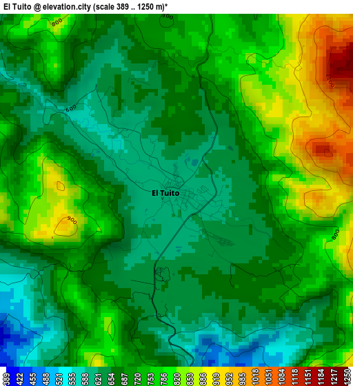
Below is the Elevation map of El Tuito, which displays elevation range with different colors. Scale of the first map is from 389 to 1250 m (1276 to 4101 ft) with average elevation of 711.3 meters (=2334 ft) [note 1]
These maps also provides idea of topography and contour of this city, they are displayed at different zoom levels. More info about maps, scale and edge coordinates you can find below images.
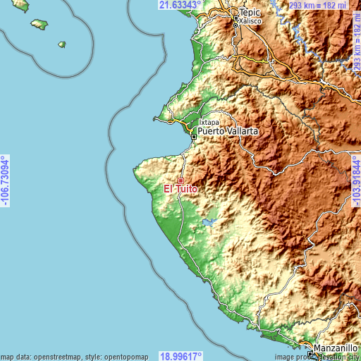
| \ | Map #1 | Topo.Map |
| Scale [m] | 389..1250 m | × |
| Scale [ft] | 1276..4101 ft | × |
| Average | 711.3 m = 2334 ft | × |
| Width | 9.16 km = 5.7 mi | 293.2 km = 182.2 mi |
| Height | 9.16 km = 5.7 mi | 293.3 km = 182.2 mi |
| ↑Max Latitude | 20.361625° | 21.63343° |
| Latitude at center | 20.32042° | 20.32042° |
| ↓Min Latitude | 20.279204° | 18.99617° |
| ← Min Longitude | -105.368635° | -106.73094° |
| Longitude center | -105.32469° | -105.32469° |
| →Max Longitude | -105.280745° | -103.91844° |
Nearby cities:
Cities around El Tuito sort by population:
• Puerto Vallarta elevation 21 m
34.4 km,  16°
16°
• Mezcales 18 m
45.8 km,  5°
5°
• Las Juntas 11 m
43.1 km, 10°
• Tomatlán 47 m
43.4 km,  169°
169°
• Las Jarretaderas 8 m
41.7 km, 7°
• José María Pino Suárez (Nuevo Nahuapa) 32 m
41.3 km,  180°
180°
• La Cruz de Loreto 25 m
37.4 km,  201°
201°
• El Tule 68 m
33.6 km, 165°
• Banus Vallarta (Verde Vallarta) 15 m
45.3 km, 13°
• Nuevo Vallarta 8 m
42.5 km,  4°
4°
• El Tequesquite 77 m
28.4 km, 174°
• Gargantillo 39 m
33.8 km, 183°
Multilingual:
 En español:
El Tuito elevación 604 m.
 En France:
El Tuito élévation 604 m.
 Auf Deutsch:
El Tuito höhe über dem Meeresspiegel ist 604 m.

Sources and notes:
- [note 1] Map square and city borders are not equal. Map elevation data is calculated only from area inside that square.
- [src 1] Elevation data from geonames database provided with same terms of usage.
- [src 2] The elevation map of El Tuito is generated using elevation data from NASA's 3 arcsec (90m) resolution SRTM data.
- [src 3] Base (background) map © OpenStreetMap contributors tiles are generated by Geofabrik and OpenTopoMap.
Copyright & License:
This El Tuito Elevation Map is licensed under CC BY-SA. You may reuse any part from this page, if you give a proper credit by linking to this URL:
 More info on terms of use page.