La Cruz de Loreto elevation
La Cruz de Loreto (Jalisco, Tomatlán), Mexico elevation is 25 meters and La Cruz de Loreto elevation in feet is 82 ft above sea level [src 1]. La Cruz de Loreto is a populated place (feature code) with elevation that is 1289 meters (4229 ft) smaller than average city elevation in Mexico.
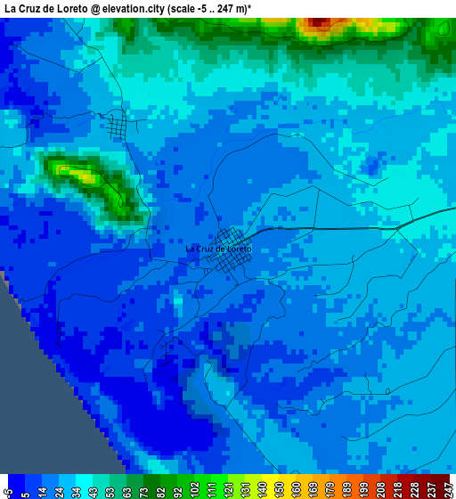
Below is the Elevation map of La Cruz de Loreto, which displays elevation range with different colors. Scale of the first map is from -5 to 247 m (-16 to 810 ft) with average elevation of 28.5 meters (=94 ft) [note 1]
These maps also provides idea of topography and contour of this city, they are displayed at different zoom levels. More info about maps, scale and edge coordinates you can find below images.
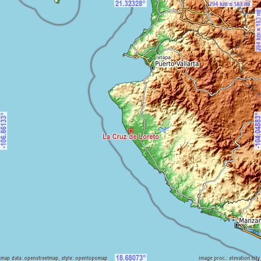
| \ | Map #1 | Topo.Map |
| Scale [m] | -5..247 m | × |
| Scale [ft] | -16..810 ft | × |
| Average | 28.5 m = 94 ft | × |
| Width | 9.18 km = 5.7 mi | 293.8 km = 182.6 mi |
| Height | 9.18 km = 5.7 mi | 293.8 km = 182.6 mi |
| ↑Max Latitude | 20.048838° | 21.32328° |
| Latitude at center | 20.00755° | 20.00755° |
| ↓Min Latitude | 19.966251° | 18.68073° |
| ← Min Longitude | -105.499025° | -106.86133° |
| Longitude center | -105.45508° | -105.45508° |
| →Max Longitude | -105.411135° | -104.04883° |
Nearby cities:
Cities around La Cruz de Loreto sort by population:
• Puerto Vallarta elevation 21 m
71.7 km,  19°
19°
• Tomatlán 47 m
22.8 km,  110°
110°
• Talpa de Allende 1159 m
78 km,  57°
57°
• Las Jarretaderas 8 m
78.5 km,  13°
13°
• El Tuito 604 m
37.4 km, 21°
• José María Morelos 14 m
46.3 km,  142°
142°
• Campo Acosta 15 m
34 km, 140°
• José María Pino Suárez (Nuevo Nahuapa) 32 m
14.8 km,  116°
116°
• El Tule 68 m
22.2 km,  84°
84°
• Nuevo Vallarta 8 m
79 km, 12°
• El Tequesquite 77 m
17.4 km,  68°
68°
• Gargantillo 39 m
11.4 km, 84°
Multilingual:
 En español:
La Cruz de Loreto elevación 25 m.
 En France:
La Cruz de Loreto élévation 25 m.
 Auf Deutsch:
La Cruz de Loreto höhe über dem Meeresspiegel ist 25 m.

Sources and notes:
- [note 1] Map square and city borders are not equal. Map elevation data is calculated only from area inside that square.
- [src 1] Elevation data from geonames database provided with same terms of usage.
- [src 2] The elevation map of La Cruz de Loreto is generated using elevation data from NASA's 3 arcsec (90m) resolution SRTM data.
- [src 3] Base (background) map © OpenStreetMap contributors tiles are generated by Geofabrik and OpenTopoMap.
Copyright & License:
This La Cruz de Loreto Elevation Map is licensed under CC BY-SA. You may reuse any part from this page, if you give a proper credit by linking to this URL:
 More info on terms of use page.