Gachupines elevation
Gachupines (Guanajuato, Ocampo), Mexico elevation is 2189 meters and Gachupines elevation in feet is 7182 ft above sea level [src 1]. Gachupines is a populated place (feature code) with elevation that is 875 meters (2871 ft) bigger than average city elevation in Mexico.
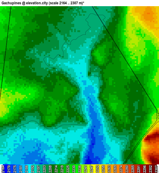
Below is the Elevation map of Gachupines, which displays elevation range with different colors. Scale of the first map is from 2164 to 2307 m (7100 to 7569 ft) with average elevation of 2211.1 meters (=7254 ft) [note 1]
These maps also provides idea of topography and contour of this city, they are displayed at different zoom levels. More info about maps, scale and edge coordinates you can find below images.
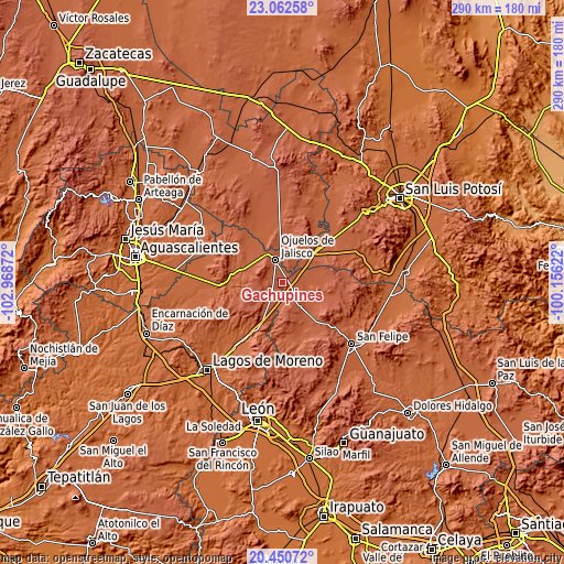
| \ | Map #1 | Topo.Map |
| Scale [m] | 2164..2307 m | × |
| Scale [ft] | 7100..7569 ft | × |
| Average | 2211.1 m = 7254 ft | × |
| Width | 9.08 km = 5.6 mi | 290.4 km = 180.4 mi |
| Height | 9.08 km = 5.6 mi | 290.4 km = 180.4 mi |
| ↑Max Latitude | 21.803397° | 23.06258° |
| Latitude at center | 21.76259° | 21.76259° |
| ↓Min Latitude | 21.721771° | 20.45072° |
| ← Min Longitude | -101.606415° | -102.96872° |
| Longitude center | -101.56247° | -101.56247° |
| →Max Longitude | -101.518525° | -100.15622° |
Nearby cities:
Cities around Gachupines sort by population:
• Ojuelos de Jalisco elevation 2226 m
11.9 km,  344°
344°
• Ocampo 2267 m
15.5 km,  146°
146°
• Villa de Arriaga 2169 m
24.7 km,  48°
48°
• Matancillas (San Isidro Matancillas) 2180 m
16.9 km,  327°
327°
• Laguna de Guadalupe 2230 m
21.6 km,  78°
78°
• La Escondida 2190 m
8.9 km,  160°
160°
• Santa Elena 2243 m
24.4 km,  13°
13°
• El Sitio 2191 m
22.6 km,  353°
353°
• La Paz 2127 m
22 km,  285°
285°
• Matanzas 2209 m
17.3 km,  213°
213°
• Vaquerías 2279 m
9.5 km,  273°
273°
• Guadalupe Victoria 2195 m
8.9 km,  219°
219°
Multilingual:
 En español:
Gachupines elevación 2189 m.
 En France:
Gachupines élévation 2189 m.
 Auf Deutsch:
Gachupines höhe über dem Meeresspiegel ist 2189 m.

Sources and notes:
- [note 1] Map square and city borders are not equal. Map elevation data is calculated only from area inside that square.
- [src 1] Elevation data from geonames database provided with same terms of usage.
- [src 2] The elevation map of Gachupines is generated using elevation data from NASA's 3 arcsec (90m) resolution SRTM data.
- [src 3] Base (background) map © OpenStreetMap contributors tiles are generated by Geofabrik and OpenTopoMap.
Copyright & License:
This Gachupines Elevation Map is licensed under CC BY-SA. You may reuse any part from this page, if you give a proper credit by linking to this URL:
 More info on terms of use page.