Jamay elevation
Jamay (Jalisco), Mexico elevation is 1535 meters and Jamay elevation in feet is 5036 ft above sea level [src 1]. Jamay is a seat of a second-order administrative division (feature code) with elevation that is 221 meters (725 ft) bigger than average city elevation in Mexico.
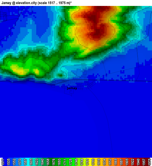
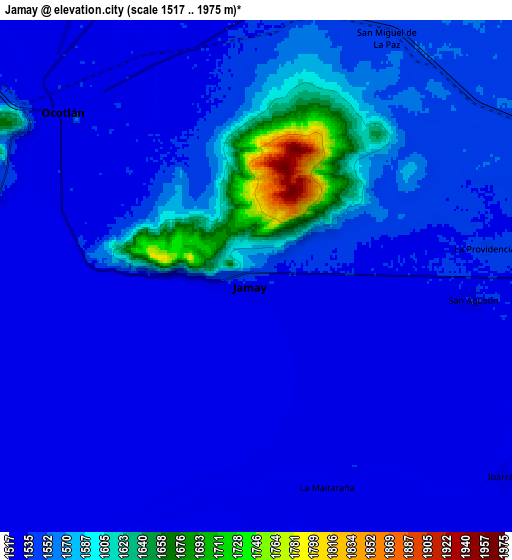
Below is the Elevation map of Jamay, which displays elevation range with different colors. Scale of the first map is from 1517 to 1975 m (4977 to 6480 ft) with average elevation of 1583.4 meters (=5195 ft) [note 1]
These maps also provides idea of topography and contour of this city, they are displayed at different zoom levels. More info about maps, scale and edge coordinates you can find below images.
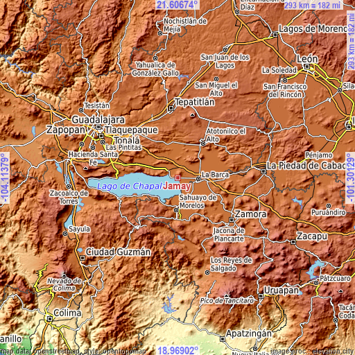
| \ | Map #1 | Map #2 | Topo.Map |
| Scale [m] | 1517..1975 m | 1517..1975 m | × |
| Scale [ft] | 4977..6480 ft | 4977..6480 ft | × |
| Average | 1583.4 m = 5195 ft | 1548.9 m = 5082 ft | × |
| Width | 9.17 km = 5.7 mi | 18.33 km = 11.4 mi | 293.3 km = 182.2 mi |
| Height | 9.17 km = 5.7 mi | 18.33 km = 11.4 mi | 293.3 km = 182.2 mi |
| ↑Max Latitude | 20.334702° | 20.375903° | 21.60674° |
| Latitude at center | 20.29349° | 20.29349° | 20.29349° |
| ↓Min Latitude | 20.252267° | 20.211033° | 18.96902° |
| ← Min Longitude | -102.751485° | -102.795431° | -104.11379° |
| Longitude center | -102.70754° | -102.70754° | -102.70754° |
| →Max Longitude | -102.663595° | -102.619649° | -101.30129° |
Nearby cities:
Cities around Jamay sort by population:
• Ocotlán elevation 1532 m
9.7 km,  314°
314°
• Cuitzeo (La Estancia) 1537 m
9.7 km,  304°
304°
• Briseñas de Matamoros 1532 m
15.4 km,  100°
100°
• San Miguel de la Paz 1552 m
9.8 km,  28°
28°
• San Martín de Zula 1535 m
13.1 km,  350°
350°
• San Agustín 1533 m
7.8 km, 96°
• Ibarra 1527 m
11.3 km,  129°
129°
• San Francisco de Rivas 1551 m
15.1 km,  69°
69°
• Cumuato 1531 m
12.8 km,  108°
108°
• San José de las Moras 1552 m
12.5 km, 73°
• San Luis de Agua Caliente 1532 m
15.7 km, 309°
• San Vicente 1583 m
16 km,  20°
20°
Multilingual:
 En español:
Jamay elevación 1535 m.
 En France:
Jamay élévation 1535 m.


Sources and notes:
- [note 1] Map square and city borders are not equal. Map elevation data is calculated only from area inside that square.
- [src 1] Elevation data from geonames database provided with same terms of usage.
- [src 2] The elevation map of Jamay is generated using elevation data from NASA's 3 arcsec (90m) resolution SRTM data.
- [src 3] Base (background) map © OpenStreetMap contributors tiles are generated by Geofabrik and OpenTopoMap.
Copyright & License:
This Jamay Elevation Map is licensed under CC BY-SA. You may reuse any part from this page, if you give a proper credit by linking to this URL:
 More info on terms of use page.