San Agustín elevation
San Agustín (Jalisco, Jamay), Mexico elevation is 1533 meters and San Agustín elevation in feet is 5030 ft above sea level [src 1]. San Agustín is a populated place (feature code) with elevation that is 219 meters (719 ft) bigger than average city elevation in Mexico.
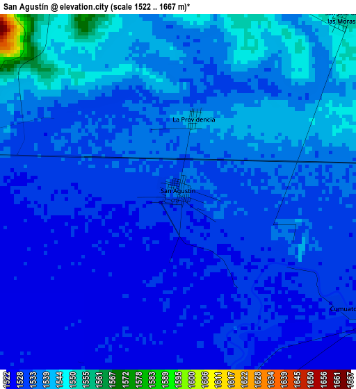
Below is the Elevation map of San Agustín, which displays elevation range with different colors. Scale of the first map is from 1522 to 1667 m (4993 to 5469 ft) with average elevation of 1533.7 meters (=5032 ft) [note 1]
These maps also provides idea of topography and contour of this city, they are displayed at different zoom levels. More info about maps, scale and edge coordinates you can find below images.
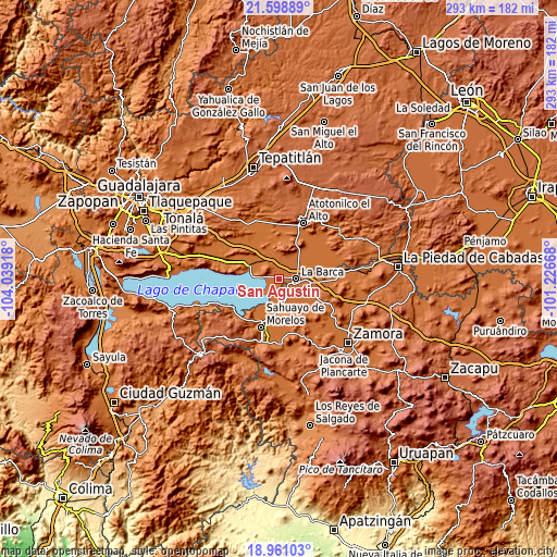
| \ | Map #1 | Topo.Map |
| Scale [m] | 1522..1667 m | × |
| Scale [ft] | 4993..5469 ft | × |
| Average | 1533.7 m = 5032 ft | × |
| Width | 9.17 km = 5.7 mi | 293.3 km = 182.2 mi |
| Height | 9.17 km = 5.7 mi | 293.3 km = 182.2 mi |
| ↑Max Latitude | 20.326784° | 21.59889° |
| Latitude at center | 20.28557° | 20.28557° |
| ↓Min Latitude | 20.244345° | 18.96103° |
| ← Min Longitude | -102.676875° | -104.03918° |
| Longitude center | -102.63293° | -102.63293° |
| →Max Longitude | -102.588985° | -101.22668° |
Nearby cities:
Cities around San Agustín sort by population:
• La Barca elevation 1537 m
9.2 km,  88°
88°
• Jamay 1535 m
7.8 km,  276°
276°
• Briseñas de Matamoros 1532 m
7.7 km,  104°
104°
• Paso de Hidalgo (Paso de Álamos) 1532 m
9.3 km, 98°
• San Miguel de la Paz 1552 m
9.9 km,  341°
341°
• Zalamea 1537 m
13.2 km,  76°
76°
• Ibarra 1527 m
6.3 km,  171°
171°
• San Francisco de Rivas 1551 m
8.8 km,  46°
46°
• Cumuato 1531 m
5.4 km,  125°
125°
• San José de las Moras 1552 m
6.2 km,  42°
42°
• La Paz de Ordaz 1545 m
12.5 km,  58°
58°
• El Fortín 1527 m
12.2 km,  163°
163°
Multilingual:
 En español:
San Agustín elevación 1533 m.
 En France:
San Agustín élévation 1533 m.
 Auf Deutsch:
San Agustín höhe über dem Meeresspiegel ist 1533 m.

Sources and notes:
- [note 1] Map square and city borders are not equal. Map elevation data is calculated only from area inside that square.
- [src 1] Elevation data from geonames database provided with same terms of usage.
- [src 2] The elevation map of San Agustín is generated using elevation data from NASA's 3 arcsec (90m) resolution SRTM data.
- [src 3] Base (background) map © OpenStreetMap contributors tiles are generated by Geofabrik and OpenTopoMap.
Copyright & License:
This San Agustín Elevation Map is licensed under CC BY-SA. You may reuse any part from this page, if you give a proper credit by linking to this URL:
 More info on terms of use page.