La Angostura elevation
La Angostura (Michoacán, Vista Hermosa), Mexico elevation is 1540 meters and La Angostura elevation in feet is 5052 ft above sea level [src 1]. La Angostura is a populated place (feature code) with elevation that is 226 meters (741 ft) bigger than average city elevation in Mexico.
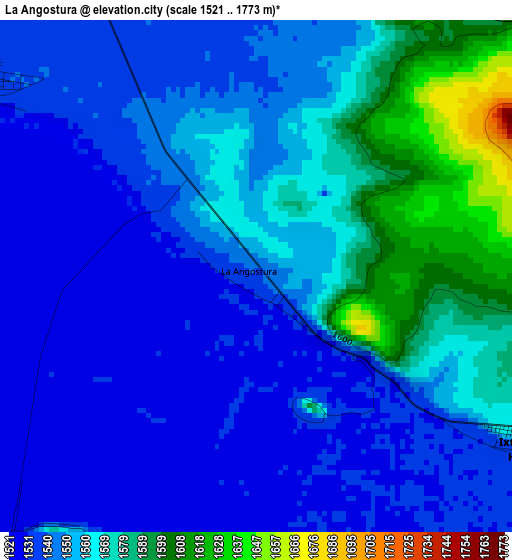
Below is the Elevation map of La Angostura, which displays elevation range with different colors. Scale of the first map is from 1521 to 1773 m (4990 to 5817 ft) with average elevation of 1553.9 meters (=5098 ft) [note 1]
These maps also provides idea of topography and contour of this city, they are displayed at different zoom levels. More info about maps, scale and edge coordinates you can find below images.
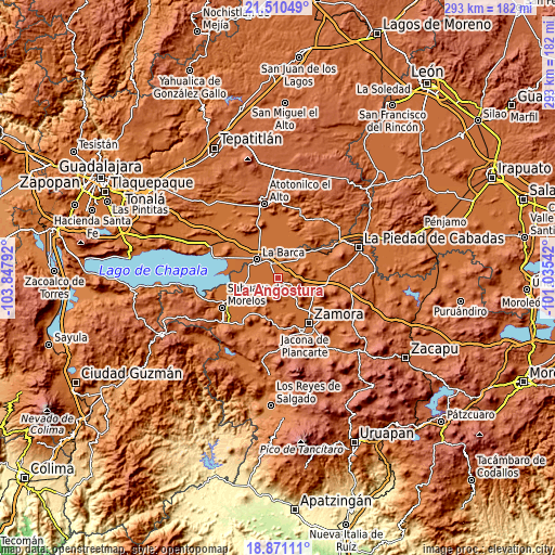
| \ | Map #1 | Topo.Map |
| Scale [m] | 1521..1773 m | × |
| Scale [ft] | 4990..5817 ft | × |
| Average | 1553.9 m = 5098 ft | × |
| Width | 9.17 km = 5.7 mi | 293.5 km = 182.4 mi |
| Height | 9.17 km = 5.7 mi | 293.5 km = 182.4 mi |
| ↑Max Latitude | 20.237628° | 21.51049° |
| Latitude at center | 20.19639° | 20.19639° |
| ↓Min Latitude | 20.155141° | 18.87111° |
| ← Min Longitude | -102.485615° | -103.84792° |
| Longitude center | -102.44167° | -102.44167° |
| →Max Longitude | -102.397725° | -101.03542° |
Nearby cities:
Cities around La Angostura sort by population:
• Vista Hermosa de Negrete elevation 1537 m
9.1 km,  337°
337°
• Ixtlán de los Hervores 1542 m
5.8 km,  121°
121°
• Paso de Hidalgo (Paso de Álamos) 1532 m
13.7 km,  308°
308°
• La Luz 1531 m
6.7 km,  222°
222°
• El Capulín 1536 m
6.1 km,  304°
304°
• San Gregorio 1531 m
11.2 km,  269°
269°
• La Plaza del Limón 1540 m
6.9 km,  170°
170°
• El Alvareño 1535 m
11.6 km,  2°
2°
• Los Charcos 1543 m
8.4 km,  24°
24°
• El Cuenqueño 1539 m
14.7 km,  353°
353°
• Tecomatán 1529 m
10.7 km,  212°
212°
• El Paracho 1537 m
13 km, 220°
Multilingual:
 En español:
La Angostura elevación 1540 m.
 En France:
La Angostura élévation 1540 m.
 Auf Deutsch:
La Angostura höhe über dem Meeresspiegel ist 1540 m.

Sources and notes:
- [note 1] Map square and city borders are not equal. Map elevation data is calculated only from area inside that square.
- [src 1] Elevation data from geonames database provided with same terms of usage.
- [src 2] The elevation map of La Angostura is generated using elevation data from NASA's 3 arcsec (90m) resolution SRTM data.
- [src 3] Base (background) map © OpenStreetMap contributors tiles are generated by Geofabrik and OpenTopoMap.
Copyright & License:
This La Angostura Elevation Map is licensed under CC BY-SA. You may reuse any part from this page, if you give a proper credit by linking to this URL:
 More info on terms of use page.