Vista Hermosa de Negrete elevation
Vista Hermosa de Negrete (Michoacán, Vista Hermosa), Mexico elevation is 1537 meters and Vista Hermosa de Negrete elevation in feet is 5043 ft above sea level [src 1]. Vista Hermosa de Negrete is a seat of a second-order administrative division (feature code) with elevation that is 223 meters (732 ft) bigger than average city elevation in Mexico.
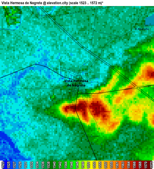
Below is the Elevation map of Vista Hermosa de Negrete, which displays elevation range with different colors. Scale of the first map is from 1523 to 1572 m (4997 to 5157 ft) with average elevation of 1538.1 meters (=5046 ft) [note 1]
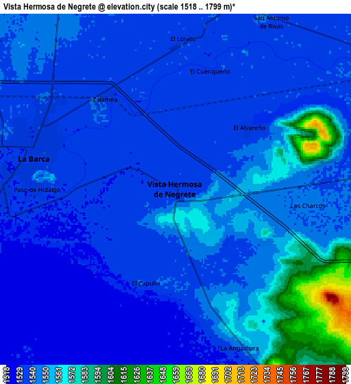
These maps also provides idea of topography and contour of this city, they are displayed at different zoom levels. More info about maps, scale and edge coordinates you can find below images.
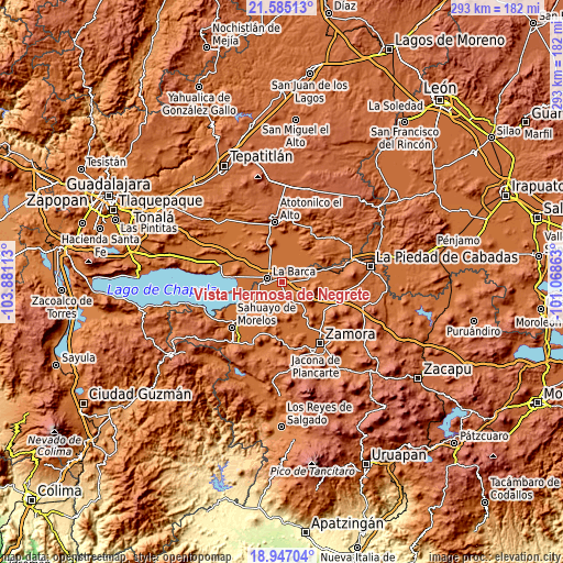
| \ | Map #1 | Map #2 | Topo.Map |
| Scale [m] | 1523..1572 m | 1518..1799 m | × |
| Scale [ft] | 4997..5157 ft | 4980..5902 ft | × |
| Average | 1538.1 m = 5046 ft | 1545.5 m = 5071 ft | × |
| Width | 9.17 km = 5.7 mi | 18.33 km = 11.4 mi | 293.3 km = 182.2 mi |
| Height | 9.17 km = 5.7 mi | 18.33 km = 11.4 mi | 293.3 km = 182.2 mi |
| ↑Max Latitude | 20.312908° | 20.354115° | 21.58513° |
| Latitude at center | 20.27169° | 20.27169° | 20.27169° |
| ↓Min Latitude | 20.230461° | 20.189221° | 18.94704° |
| ← Min Longitude | -102.518825° | -102.562771° | -103.88113° |
| Longitude center | -102.47488° | -102.47488° | -102.47488° |
| →Max Longitude | -102.430935° | -102.386989° | -101.06863° |
Nearby cities:
Cities around Vista Hermosa de Negrete sort by population:
• La Barca elevation 1537 m
7.5 km,  283°
283°
• Briseñas de Matamoros 1532 m
9.1 km,  267°
267°
• Paso de Hidalgo (Paso de Álamos) 1532 m
7.3 km, 270°
• El Capulín 1536 m
5.1 km,  197°
197°
• San Antonio de Rivas 1538 m
10 km,  29°
29°
• Zalamea 1537 m
5.9 km,  322°
322°
• El Alvareño 1535 m
5.1 km,  50°
50°
• La Angostura 1540 m
9.1 km,  157°
157°
• Los Charcos 1543 m
7 km,  96°
96°
• El Loreto Occidental 1539 m
7.9 km,  3°
3°
• La Paz de Ordaz 1545 m
10 km, 324°
• El Cuenqueño 1539 m
6.5 km,  16°
16°
Multilingual:
 En español:
Vista Hermosa de Negrete elevación 1537 m.
 En France:
Vista Hermosa de Negrete élévation 1537 m.
 Auf Deutsch:
Vista Hermosa de Negrete höhe über dem Meeresspiegel ist 1537 m.
 На русском:
Vista Hermosa de Negrete высота над уровнем моря 1537 м
Sources and notes:
- [note 1] Map square and city borders are not equal. Map elevation data is calculated only from area inside that square.
- [src 1] Elevation data from geonames database provided with same terms of usage.
- [src 2] The elevation map of Vista Hermosa de Negrete is generated using elevation data from NASA's 3 arcsec (90m) resolution SRTM data.
- [src 3] Base (background) map © OpenStreetMap contributors tiles are generated by Geofabrik and OpenTopoMap.
Copyright & License:
This Vista Hermosa de Negrete Elevation Map is licensed under CC BY-SA. You may reuse any part from this page, if you give a proper credit by linking to this URL:
 More info on terms of use page.