La Fuente elevation
La Fuente (Querétaro, Tequisquiapan), Mexico elevation is 1918 meters and La Fuente elevation in feet is 6293 ft above sea level [src 1]. La Fuente is a populated place (feature code) with elevation that is 604 meters (1982 ft) bigger than average city elevation in Mexico.
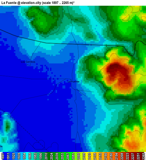
Below is the Elevation map of La Fuente, which displays elevation range with different colors. Scale of the first map is from 1897 to 2265 m (6224 to 7431 ft) with average elevation of 1975.3 meters (=6481 ft) [note 1]
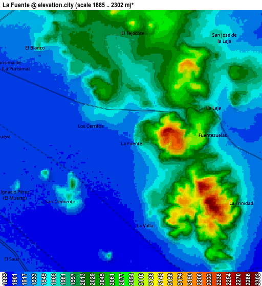
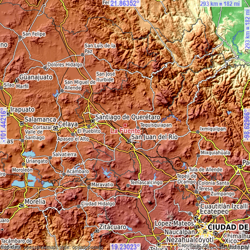
These maps also provides idea of topography and contour of this city, they are displayed at different zoom levels. More info about maps, scale and edge coordinates you can find below images.
| \ | Map #1 | Map #2 | Topo.Map |
| Scale [m] | 1897..2265 m | 1885..2302 m | × |
| Scale [ft] | 6224..7431 ft | 6184..7552 ft | × |
| Average | 1975.3 m = 6481 ft | 1962.9 m = 6440 ft | × |
| Width | 9.15 km = 5.7 mi | 18.3 km = 11.4 mi | 292.8 km = 181.9 mi |
| Height | 9.15 km = 5.7 mi | 18.3 km = 11.4 mi | 292.8 km = 181.9 mi |
| ↑Max Latitude | 20.593693° | 20.634824° | 21.86352° |
| Latitude at center | 20.55255° | 20.55255° | 20.55255° |
| ↓Min Latitude | 20.511396° | 20.470231° | 19.23023° |
| ← Min Longitude | -100.079855° | -100.123801° | -101.44216° |
| Longitude center | -100.03591° | -100.03591° | -100.03591° |
| →Max Longitude | -99.991965° | -99.948019° | -98.62966° |
Nearby cities:
Cities around La Fuente sort by population:
• La Valla elevation 1922 m
6 km,  170°
170°
• San Clemente 1921 m
6.6 km,  230°
230°
• El Blanco 1946 m
9.4 km,  313°
313°
• Fuentezuelas 1969 m
5.6 km,  86°
86°
• El Tejocote 2020 m
7.5 km,  1°
1°
• Guadalupe Septién 1921 m
8.5 km,  250°
250°
• El Organal 1910 m
8.6 km,  193°
193°
• Los Cerritos 1917 m
3 km,  290°
290°
• La Trinidad 1965 m
8.6 km,  118°
118°
• Ignacio Pérez 1928 m
8.5 km, 246°
• Noria Nueva 1909 m
9.3 km,  272°
272°
• La Laja 1961 m
6.3 km,  66°
66°
Multilingual:
 En español:
La Fuente elevación 1918 m.
 En France:
La Fuente élévation 1918 m.
 Auf Deutsch:
La Fuente höhe über dem Meeresspiegel ist 1918 m.

Sources and notes:
- [note 1] Map square and city borders are not equal. Map elevation data is calculated only from area inside that square.
- [src 1] Elevation data from geonames database provided with same terms of usage.
- [src 2] The elevation map of La Fuente is generated using elevation data from NASA's 3 arcsec (90m) resolution SRTM data.
- [src 3] Base (background) map © OpenStreetMap contributors tiles are generated by Geofabrik and OpenTopoMap.
Copyright & License:
This La Fuente Elevation Map is licensed under CC BY-SA. You may reuse any part from this page, if you give a proper credit by linking to this URL:
 More info on terms of use page.