La Luz elevation
La Luz (Coahuila, Matamoros), Mexico elevation is 1114 meters and La Luz elevation in feet is 3655 ft above sea level [src 1]. La Luz is a populated place (feature code) with elevation that is 200 meters (656 ft) smaller than average city elevation in Mexico.
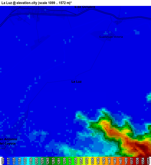
Below is the Elevation map of La Luz, which displays elevation range with different colors. Scale of the first map is from 1099 to 1572 m (3606 to 5157 ft) with average elevation of 1132.6 meters (=3716 ft) [note 1]
These maps also provides idea of topography and contour of this city, they are displayed at different zoom levels. More info about maps, scale and edge coordinates you can find below images.
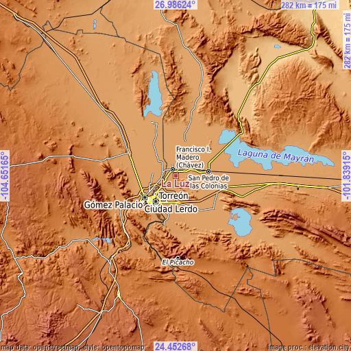
| \ | Map #1 | Topo.Map |
| Scale [m] | 1099..1572 m | × |
| Scale [ft] | 3606..5157 ft | × |
| Average | 1132.6 m = 3716 ft | × |
| Width | 8.8 km = 5.5 mi | 281.7 km = 175 mi |
| Height | 8.8 km = 5.5 mi | 281.7 km = 175 mi |
| ↑Max Latitude | 25.765793° | 26.98624° |
| Latitude at center | 25.72621° | 25.72621° |
| ↓Min Latitude | 25.686614° | 24.45268° |
| ← Min Longitude | -103.289345° | -104.65165° |
| Longitude center | -103.2454° | -103.2454° |
| →Max Longitude | -103.201455° | -101.83915° |
Nearby cities:
Cities around La Luz sort by population:
• Francisco I. Madero elevation 1112 m
5.8 km,  333°
333°
• San Antonio del Coyote 1118 m
5.4 km,  228°
228°
• Coyote 1117 m
5.2 km, 228°
• Luchanas 1110 m
8.9 km,  35°
35°
• Seis de Octubre (Santo Niño) 1114 m
4.2 km,  8°
8°
• Solima 1114 m
7.7 km,  203°
203°
• Nuevo León 1117 m
5 km,  260°
260°
• Virginias 1108 m
8.7 km,  341°
341°
• Veinte de Noviembre 1118 m
8.6 km, 259°
• Santa Ana del Pilar 1118 m
6.6 km,  253°
253°
• Jaboncillo 1114 m
3.2 km,  320°
320°
• Compuertas 1114 m
6.2 km,  291°
291°
Multilingual:
 En español:
La Luz elevación 1114 m.
 En France:
La Luz élévation 1114 m.


Sources and notes:
- [note 1] Map square and city borders are not equal. Map elevation data is calculated only from area inside that square.
- [src 1] Elevation data from geonames database provided with same terms of usage.
- [src 2] The elevation map of La Luz is generated using elevation data from NASA's 3 arcsec (90m) resolution SRTM data.
- [src 3] Base (background) map © OpenStreetMap contributors tiles are generated by Geofabrik and OpenTopoMap.
Copyright & License:
This La Luz Elevation Map is licensed under CC BY-SA. You may reuse any part from this page, if you give a proper credit by linking to this URL:
 More info on terms of use page.