La Sauceda elevation
La Sauceda (Guanajuato, San Diego de la Unión), Mexico elevation is 2058 meters and La Sauceda elevation in feet is 6752 ft above sea level [src 1]. La Sauceda is a populated place (feature code) with elevation that is 744 meters (2441 ft) bigger than average city elevation in Mexico.
Below is the Elevation map of La Sauceda, which displays elevation range with different colors. Scale of the first map is from 2019 to 2381 m (6624 to 7812 ft) with average elevation of 2098.1 meters (=6884 ft) [note 1]
These maps also provides idea of topography and contour of this city, they are displayed at different zoom levels. More info about maps, scale and edge coordinates you can find below images.
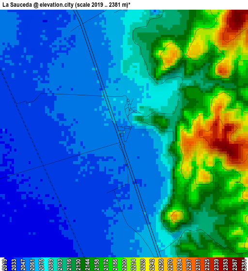
| \ | Map #1 | Topo.Map |
| Scale [m] | 2019..2381 m | × |
| Scale [ft] | 6624..7812 ft | × |
| Average | 2098.1 m = 6884 ft | × |
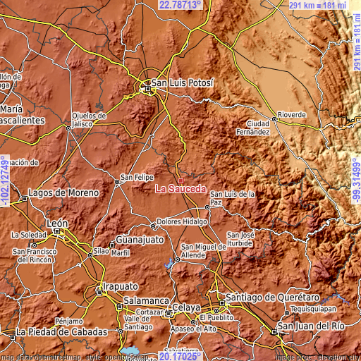
| Width | 9.09 km = 5.6 mi | 291 km = 180.8 mi |
| Height | 9.09 km = 5.6 mi | 291 km = 180.8 mi |
| ↑Max Latitude | 21.525456° | 22.78713° |
| Latitude at center | 21.48457° | 21.48457° |
| ↓Min Latitude | 21.443672° | 20.17025° |
| ← Min Longitude | -100.765185° | -102.12749° |
| Longitude center | -100.72124° | -100.72124° |
| →Max Longitude | -100.677295° | -99.31499° |
Nearby cities:
Cities around La Sauceda sort by population:
• San Luis de la Paz elevation 2019 m
29.6 km,  134°
134°
• San Diego de la Unión 2071 m
15.8 km,  263°
263°
• Tierra Nueva 1788 m
25.6 km,  36°
36°
• San Juan Pan de Arriba 2111 m
20.6 km,  265°
265°
• Los Dolores (Las Quince Letras) 1999 m
24.6 km,  139°
139°
• Fábrica de Melchor 1942 m
28 km,  318°
318°
• El Fuerte 1748 m
26.1 km,  13°
13°
• San Nicolás del Cármen 1998 m
29.3 km, 142°
• El Tejocote (El Domingo) 1911 m
29.2 km, 316°
• San Ignacio 2012 m
29.5 km, 139°
• Ejido la Pitahaya (Santo Domingo) 1883 m
14.1 km,  343°
343°
• Yerbabuena 1861 m
22.9 km,  347°
347°
Multilingual:
 En español:
La Sauceda elevación 2058 m.
 En France:
La Sauceda élévation 2058 m.
 Auf Deutsch:
La Sauceda höhe über dem Meeresspiegel ist 2058 m.

Sources and notes:
- [note 1] Map square and city borders are not equal. Map elevation data is calculated only from area inside that square.
- [src 1] Elevation data from geonames database provided with same terms of usage.
- [src 2] The elevation map of La Sauceda is generated using elevation data from NASA's 3 arcsec (90m) resolution SRTM data.
- [src 3] Base (background) map © OpenStreetMap contributors tiles are generated by Geofabrik and OpenTopoMap.
Copyright & License:
This La Sauceda Elevation Map is licensed under CC BY-SA. You may reuse any part from this page, if you give a proper credit by linking to this URL:
 More info on terms of use page.