Fábrica de Melchor elevation
Fábrica de Melchor (Guanajuato, San Felipe), Mexico elevation is 1942 meters and Fábrica de Melchor elevation in feet is 6371 ft above sea level [src 1]. Fábrica de Melchor is a populated place (feature code) with elevation that is 628 meters (2060 ft) bigger than average city elevation in Mexico.
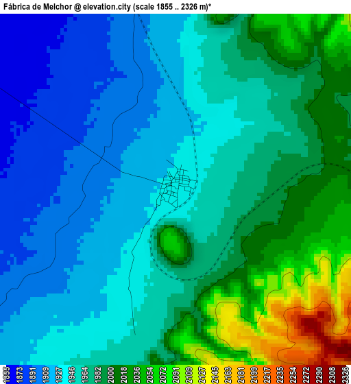
Below is the Elevation map of Fábrica de Melchor, which displays elevation range with different colors. Scale of the first map is from 1855 to 2326 m (6086 to 7631 ft) with average elevation of 1966.6 meters (=6452 ft) [note 1]
These maps also provides idea of topography and contour of this city, they are displayed at different zoom levels. More info about maps, scale and edge coordinates you can find below images.
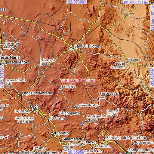
| \ | Map #1 | Topo.Map |
| Scale [m] | 1855..2326 m | × |
| Scale [ft] | 6086..7631 ft | × |
| Average | 1966.6 m = 6452 ft | × |
| Width | 9.08 km = 5.6 mi | 290.6 km = 180.6 mi |
| Height | 9.08 km = 5.6 mi | 290.6 km = 180.6 mi |
| ↑Max Latitude | 21.713063° | 22.97306° |
| Latitude at center | 21.67223° | 21.67223° |
| ↓Min Latitude | 21.631385° | 20.35956° |
| ← Min Longitude | -100.945655° | -102.30796° |
| Longitude center | -100.90171° | -100.90171° |
| →Max Longitude | -100.857765° | -99.49546° |
Nearby cities:
Cities around Fábrica de Melchor sort by population:
• Villa de Reyes elevation 1815 m
14.9 km,  347°
347°
• El Rosario 1873 m
7.3 km,  339°
339°
• El Carretón 1876 m
9.4 km,  240°
240°
• La Ventilla 1865 m
17.4 km,  310°
310°
• Guadalupe 1835 m
9.2 km,  302°
302°
• El Tejocote (El Domingo) 1911 m
1.4 km,  287°
287°
• Ejido la Pitahaya (Santo Domingo) 1883 m
16.3 km,  116°
116°
• San José de Rancho Nuevo (Los Arrieros) 1890 m
13.5 km,  231°
231°
• Yerbabuena 1861 m
14 km,  83°
83°
• Alberto Carrera Torres 1841 m
15.9 km, 314°
• San Francisco 1882 m
16.8 km,  255°
255°
• El Zapote 1883 m
16.8 km, 294°
Multilingual:
 En español:
Fábrica de Melchor elevación 1942 m.
 En France:
Fábrica de Melchor élévation 1942 m.
 Auf Deutsch:
Fábrica de Melchor höhe über dem Meeresspiegel ist 1942 m.
 На русском:
Fábrica de Melchor высота над уровнем моря 1942 м
Sources and notes:
- [note 1] Map square and city borders are not equal. Map elevation data is calculated only from area inside that square.
- [src 1] Elevation data from geonames database provided with same terms of usage.
- [src 2] The elevation map of Fábrica de Melchor is generated using elevation data from NASA's 3 arcsec (90m) resolution SRTM data.
- [src 3] Base (background) map © OpenStreetMap contributors tiles are generated by Geofabrik and OpenTopoMap.
Copyright & License:
This Fábrica de Melchor Elevation Map is licensed under CC BY-SA. You may reuse any part from this page, if you give a proper credit by linking to this URL:
 More info on terms of use page.