Mapimí elevation
Mapimí (Durango), Mexico elevation is 1303 meters and Mapimí elevation in feet is 4275 ft above sea level [src 1]. Mapimí is a seat of a second-order administrative division (feature code) with elevation that is 11 meters (36 ft) smaller than average city elevation in Mexico.
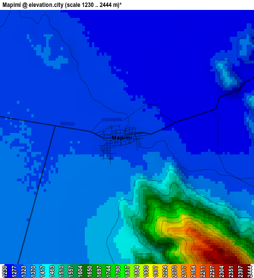
Below is the Elevation map of Mapimí, which displays elevation range with different colors. Scale of the first map is from 1230 to 2444 m (4035 to 8018 ft) with average elevation of 1366.9 meters (=4485 ft) [note 1]
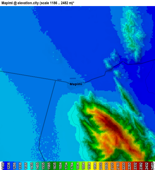
These maps also provides idea of topography and contour of this city, they are displayed at different zoom levels. More info about maps, scale and edge coordinates you can find below images.
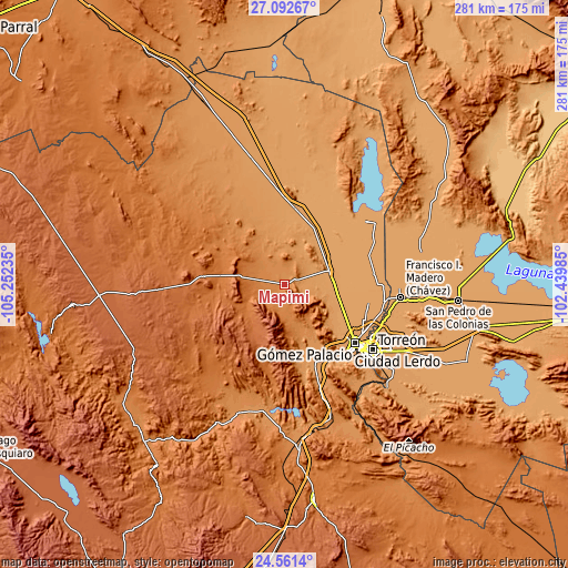
| \ | Map #1 | Map #2 | Topo.Map |
| Scale [m] | 1230..2444 m | 1186..2482 m | × |
| Scale [ft] | 4035..8018 ft | 3891..8143 ft | × |
| Average | 1366.9 m = 4485 ft | 1382.9 m = 4537 ft | × |
| Width | 8.8 km = 5.5 mi | 17.59 km = 10.9 mi | 281.5 km = 174.9 mi |
| Height | 8.8 km = 5.5 mi | 17.59 km = 10.9 mi | 281.5 km = 174.9 mi |
| ↑Max Latitude | 25.873347° | 25.912881° | 27.09267° |
| Latitude at center | 25.8338° | 25.8338° | 25.8338° |
| ↓Min Latitude | 25.79424° | 25.754667° | 24.5614° |
| ← Min Longitude | -103.890045° | -103.933991° | -105.25235° |
| Longitude center | -103.8461° | -103.8461° | -103.8461° |
| →Max Longitude | -103.802155° | -103.758209° | -102.43985° |
Nearby cities:
Cities around Mapimí sort by population:
• Bermejillo elevation 1123 m
23.3 km,  75°
75°
• La Popular 1117 m
41.7 km,  114°
114°
• León Guzmán 1154 m
41.6 km,  153°
153°
• Pastor Rovaix 1117 m
37.6 km,  116°
116°
• Transporte 1124 m
37.8 km,  125°
125°
• Juan E. García 1163 m
41 km,  157°
157°
• El Vergel 1125 m
39 km, 123°
• San Jacinto 1172 m
40.8 km, 164°
• Seis de Octubre 1109 m
27.4 km,  94°
94°
• La Goma 1159 m
41.9 km, 157°
• La Luz 1145 m
32.3 km, 133°
• El Rayo 1153 m
42.2 km, 145°
Multilingual:
 En español:
Mapimí elevación 1303 m.
 En France:
Mapimí élévation 1303 m.


Sources and notes:
- [note 1] Map square and city borders are not equal. Map elevation data is calculated only from area inside that square.
- [src 1] Elevation data from geonames database provided with same terms of usage.
- [src 2] The elevation map of Mapimí is generated using elevation data from NASA's 3 arcsec (90m) resolution SRTM data.
- [src 3] Base (background) map © OpenStreetMap contributors tiles are generated by Geofabrik and OpenTopoMap.
Copyright & License:
This Mapimí Elevation Map is licensed under CC BY-SA. You may reuse any part from this page, if you give a proper credit by linking to this URL:
 More info on terms of use page.