La Luz elevation
La Luz (Durango, Lerdo), Mexico elevation is 1145 meters and La Luz elevation in feet is 3757 ft above sea level [src 1]. La Luz is a populated place (feature code) with elevation that is 169 meters (554 ft) smaller than average city elevation in Mexico.
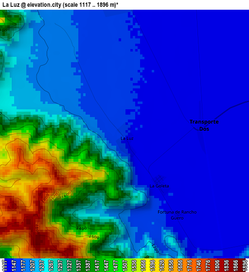
Below is the Elevation map of La Luz, which displays elevation range with different colors. Scale of the first map is from 1117 to 1896 m (3665 to 6220 ft) with average elevation of 1258.3 meters (=4128 ft) [note 1]
These maps also provides idea of topography and contour of this city, they are displayed at different zoom levels. More info about maps, scale and edge coordinates you can find below images.
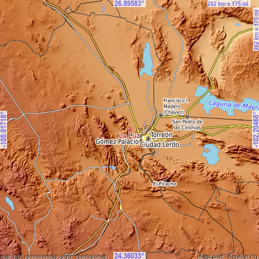
| \ | Map #1 | Topo.Map |
| Scale [m] | 1117..1896 m | × |
| Scale [ft] | 3665..6220 ft | × |
| Average | 1258.3 m = 4128 ft | × |
| Width | 8.81 km = 5.5 mi | 281.9 km = 175.2 mi |
| Height | 8.81 km = 5.5 mi | 281.9 km = 175.2 mi |
| ↑Max Latitude | 25.674423° | 26.89583° |
| Latitude at center | 25.63481° | 25.63481° |
| ↓Min Latitude | 25.595184° | 24.36033° |
| ← Min Longitude | -103.654875° | -105.01718° |
| Longitude center | -103.61093° | -103.61093° |
| →Max Longitude | -103.566985° | -102.20468° |
Nearby cities:
Cities around La Luz sort by population:
• Gómez Palacio elevation 1135 m
13.6 km,  122°
122°
• Ciudad Lerdo 1139 m
13.9 km,  141°
141°
• Villa Juárez 1156 m
16 km,  173°
173°
• La Popular 1117 m
15.3 km,  71°
71°
• León Guzmán 1154 m
15.8 km,  197°
197°
• Pastor Rovaix 1117 m
11.4 km,  62°
62°
• Transporte 1124 m
7 km,  90°
90°
• El Vergel 1125 m
9 km, 86°
• Los Angeles 1147 m
13.3 km,  160°
160°
• Seis de Enero 1149 m
12.7 km,  175°
175°
• Las Cuevas 1145 m
16.4 km, 157°
• El Rayo 1153 m
12.6 km, 178°
Multilingual:
 En español:
La Luz elevación 1145 m.
 En France:
La Luz élévation 1145 m.


Sources and notes:
- [note 1] Map square and city borders are not equal. Map elevation data is calculated only from area inside that square.
- [src 1] Elevation data from geonames database provided with same terms of usage.
- [src 2] The elevation map of La Luz is generated using elevation data from NASA's 3 arcsec (90m) resolution SRTM data.
- [src 3] Base (background) map © OpenStreetMap contributors tiles are generated by Geofabrik and OpenTopoMap.
Copyright & License:
This La Luz Elevation Map is licensed under CC BY-SA. You may reuse any part from this page, if you give a proper credit by linking to this URL:
 More info on terms of use page.