Villa Juárez elevation
Villa Juárez (Durango, Lerdo), Mexico elevation is 1156 meters and Villa Juárez elevation in feet is 3793 ft above sea level [src 1]. Villa Juárez is a populated place (feature code) with elevation that is 158 meters (518 ft) smaller than average city elevation in Mexico.
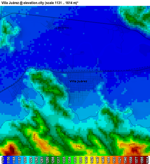
Below is the Elevation map of Villa Juárez, which displays elevation range with different colors. Scale of the first map is from 1131 to 1614 m (3711 to 5295 ft) with average elevation of 1205.8 meters (=3956 ft) [note 1]
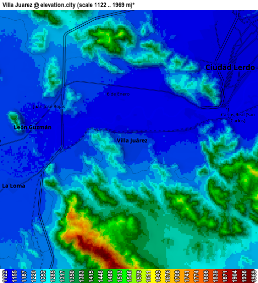
These maps also provides idea of topography and contour of this city, they are displayed at different zoom levels. More info about maps, scale and edge coordinates you can find below images.
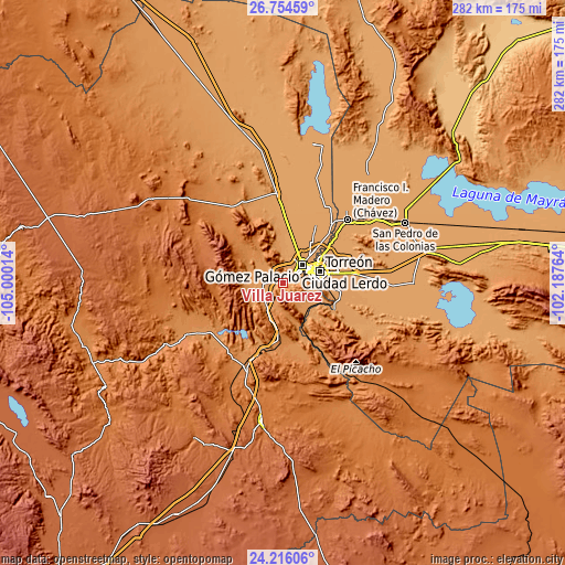
| \ | Map #1 | Map #2 | Topo.Map |
| Scale [m] | 1131..1614 m | 1122..1969 m | × |
| Scale [ft] | 3711..5295 ft | 3681..6460 ft | × |
| Average | 1205.8 m = 3956 ft | 1248.5 m = 4096 ft | × |
| Width | 8.82 km = 5.5 mi | 17.64 km = 11 mi | 282.3 km = 175.4 mi |
| Height | 8.82 km = 5.5 mi | 17.64 km = 11 mi | 282.3 km = 175.4 mi |
| ↑Max Latitude | 25.53169° | 25.571338° | 26.75459° |
| Latitude at center | 25.49203° | 25.49203° | 25.49203° |
| ↓Min Latitude | 25.452356° | 25.41267° | 24.21606° |
| ← Min Longitude | -103.637835° | -103.681781° | -105.00014° |
| Longitude center | -103.59389° | -103.59389° | -103.59389° |
| →Max Longitude | -103.549945° | -103.505999° | -102.18764° |
Nearby cities:
Cities around Villa Juárez sort by population:
• Ciudad Lerdo elevation 1139 m
8.6 km,  54°
54°
• La Loma 1163 m
8.6 km,  248°
248°
• León Guzmán 1154 m
6.6 km,  277°
277°
• El Huarache (El Guarache) 1148 m
11.2 km,  73°
73°
• Juan E. García 1163 m
9.8 km,  270°
270°
• Villa de Guadalupe 1145 m
10.8 km,  76°
76°
• Los Angeles 1147 m
4.3 km,  38°
38°
• La Goma 1159 m
9.6 km, 265°
• Seis de Enero 1149 m
3.3 km,  346°
346°
• Álvaro Obregón 1139 m
9.3 km, 74°
• Las Cuevas 1145 m
4.5 km, 81°
• El Rayo 1153 m
3.5 km,  336°
336°
Multilingual:
 En español:
Villa Juárez elevación 1156 m.
 En France:
Villa Juárez élévation 1156 m.
 Auf Deutsch:
Villa Juárez höhe über dem Meeresspiegel ist 1156 m.

Sources and notes:
- [note 1] Map square and city borders are not equal. Map elevation data is calculated only from area inside that square.
- [src 1] Elevation data from geonames database provided with same terms of usage.
- [src 2] The elevation map of Villa Juárez is generated using elevation data from NASA's 3 arcsec (90m) resolution SRTM data.
- [src 3] Base (background) map © OpenStreetMap contributors tiles are generated by Geofabrik and OpenTopoMap.
Copyright & License:
This Villa Juárez Elevation Map is licensed under CC BY-SA. You may reuse any part from this page, if you give a proper credit by linking to this URL:
 More info on terms of use page.