Marroquín elevation
Marroquín (Guanajuato, Apaseo el Alto), Mexico elevation is 1857 meters and Marroquín elevation in feet is 6093 ft above sea level [src 1]. Marroquín is a populated place (feature code) with elevation that is 543 meters (1781 ft) bigger than average city elevation in Mexico.
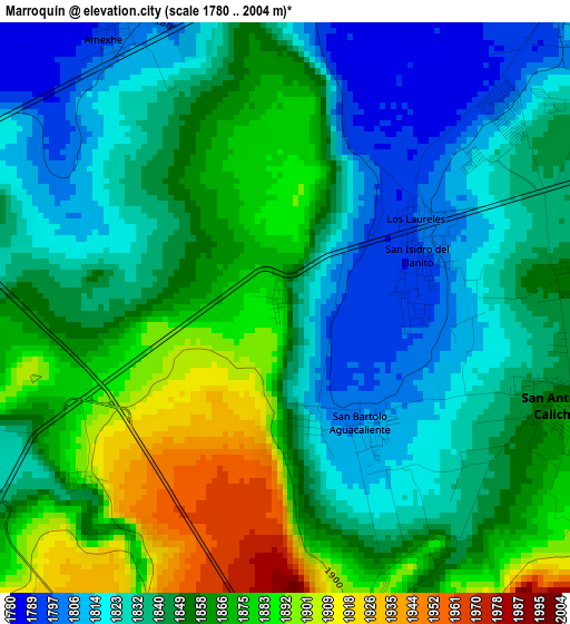
Below is the Elevation map of Marroquín, which displays elevation range with different colors. Scale of the first map is from 1780 to 2004 m (5840 to 6575 ft) with average elevation of 1849.1 meters (=6067 ft) [note 1]
These maps also provides idea of topography and contour of this city, they are displayed at different zoom levels. More info about maps, scale and edge coordinates you can find below images.
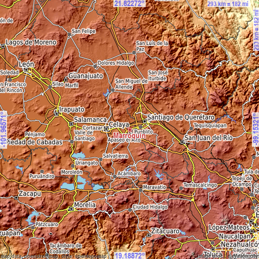
| \ | Map #1 | Topo.Map |
| Scale [m] | 1780..2004 m | × |
| Scale [ft] | 5840..6575 ft | × |
| Average | 1849.1 m = 6067 ft | × |
| Width | 9.15 km = 5.7 mi | 292.9 km = 182 mi |
| Height | 9.15 km = 5.7 mi | 292.9 km = 182 mi |
| ↑Max Latitude | 20.552534° | 21.82272° |
| Latitude at center | 20.51138° | 20.51138° |
| ↓Min Latitude | 20.470215° | 19.18872° |
| ← Min Longitude | -100.603405° | -101.96571° |
| Longitude center | -100.55946° | -100.55946° |
| →Max Longitude | -100.515515° | -99.15321° |
Nearby cities:
Cities around Marroquín sort by population:
• Colonia los Ángeles elevation 1857 m
7.9 km,  70°
70°
• San Bartolomé Aguas Calientes 1805 m
2.1 km,  146°
146°
• San Juan del Llanito 1795 m
2.1 km,  82°
82°
• San Pedro Tenango 1789 m
7.6 km,  266°
266°
• Ameche 1802 m
5.2 km,  331°
331°
• Caleras de Ameche 1802 m
5.6 km,  359°
359°
• San Antonio Calichar 1858 m
4.6 km,  110°
110°
• Coachiti 1791 m
6.2 km, 329°
• La Norita 1806 m
6.5 km,  43°
43°
• El Nacimiento 1802 m
5.9 km,  297°
297°
• Lourdes 1956 m
8.6 km,  89°
89°
• El Espejo 1931 m
7.9 km,  175°
175°
Multilingual:
 En español:
Marroquín elevación 1857 m.
 En France:
Marroquín élévation 1857 m.
 Auf Deutsch:
Marroquín höhe über dem Meeresspiegel ist 1857 m.

Sources and notes:
- [note 1] Map square and city borders are not equal. Map elevation data is calculated only from area inside that square.
- [src 1] Elevation data from geonames database provided with same terms of usage.
- [src 2] The elevation map of Marroquín is generated using elevation data from NASA's 3 arcsec (90m) resolution SRTM data.
- [src 3] Base (background) map © OpenStreetMap contributors tiles are generated by Geofabrik and OpenTopoMap.
Copyright & License:
This Marroquín Elevation Map is licensed under CC BY-SA. You may reuse any part from this page, if you give a proper credit by linking to this URL:
 More info on terms of use page.