San Pedro Tenango elevation
San Pedro Tenango (Guanajuato, Apaseo el Grande), Mexico elevation is 1789 meters and San Pedro Tenango elevation in feet is 5869 ft above sea level [src 1]. San Pedro Tenango is a populated place (feature code) with elevation that is 475 meters (1558 ft) bigger than average city elevation in Mexico.
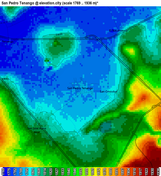
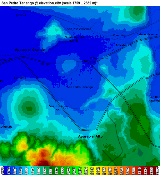
Below is the Elevation map of San Pedro Tenango, which displays elevation range with different colors. Scale of the first map is from 1769 to 1936 m (5804 to 6352 ft) with average elevation of 1812.5 meters (=5947 ft) [note 1]
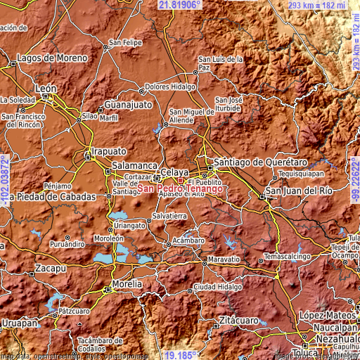
These maps also provides idea of topography and contour of this city, they are displayed at different zoom levels. More info about maps, scale and edge coordinates you can find below images.
| \ | Map #1 | Map #2 | Topo.Map |
| Scale [m] | 1769..1936 m | 1759..2382 m | × |
| Scale [ft] | 5804..6352 ft | 5771..7815 ft | × |
| Average | 1812.5 m = 5947 ft | 1860.4 m = 6104 ft | × |
| Width | 9.15 km = 5.7 mi | 18.31 km = 11.4 mi | 292.9 km = 182 mi |
| Height | 9.15 km = 5.7 mi | 18.31 km = 11.4 mi | 292.9 km = 182 mi |
| ↑Max Latitude | 20.548845° | 20.589988° | 21.81906° |
| Latitude at center | 20.50769° | 20.50769° | 20.50769° |
| ↓Min Latitude | 20.466524° | 20.425347° | 19.185° |
| ← Min Longitude | -100.676415° | -100.720361° | -102.03872° |
| Longitude center | -100.63247° | -100.63247° | -100.63247° |
| →Max Longitude | -100.588525° | -100.544579° | -99.22622° |
Nearby cities:
Cities around San Pedro Tenango sort by population:
• Apaseo el Alto elevation 1862 m
5.7 km,  167°
167°
• Apaseo el Grande 1774 m
6.8 km,  307°
307°
• San José de Agua Azul 1815 m
3.4 km,  226°
226°
• Ameche 1802 m
7.1 km,  45°
45°
• Tenango el Nuevo 1776 m
4.8 km,  302°
302°
• La Palma 1786 m
6.9 km,  277°
277°
• Coachiti 1791 m
7.3 km,  37°
37°
• El Nacimiento 1802 m
3.9 km, 36°
• El Tunal 1800 m
7 km,  10°
10°
• San José Viborillas 1791 m
6.7 km,  358°
358°
• La Purísima 1790 m
4.2 km, 280°
• Guadalupe del Monte 1796 m
5.5 km,  351°
351°
Multilingual:
 En español:
San Pedro Tenango elevación 1789 m.
 En France:
San Pedro Tenango élévation 1789 m.
 Auf Deutsch:
San Pedro Tenango höhe über dem Meeresspiegel ist 1789 m.
 На русском:
San Pedro Tenango высота над уровнем моря 1789 м
Sources and notes:
- [note 1] Map square and city borders are not equal. Map elevation data is calculated only from area inside that square.
- [src 1] Elevation data from geonames database provided with same terms of usage.
- [src 2] The elevation map of San Pedro Tenango is generated using elevation data from NASA's 3 arcsec (90m) resolution SRTM data.
- [src 3] Base (background) map © OpenStreetMap contributors tiles are generated by Geofabrik and OpenTopoMap.
Copyright & License:
This San Pedro Tenango Elevation Map is licensed under CC BY-SA. You may reuse any part from this page, if you give a proper credit by linking to this URL:
 More info on terms of use page.