Monteón elevation
Monteón (Nayarit, Compostela), Mexico elevation is 15 meters and Monteón elevation in feet is 49 ft above sea level [src 1]. Monteón is a populated place (feature code) with elevation that is 1299 meters (4262 ft) smaller than average city elevation in Mexico.
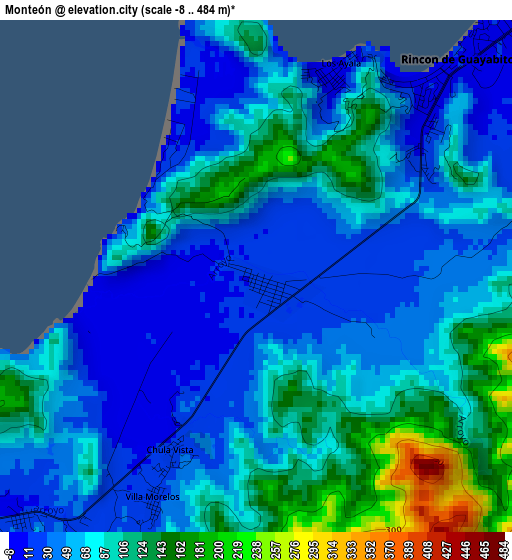
Below is the Elevation map of Monteón, which displays elevation range with different colors. Scale of the first map is from -8 to 484 m (-26 to 1588 ft) with average elevation of 73.5 meters (=241 ft) [note 1]
These maps also provides idea of topography and contour of this city, they are displayed at different zoom levels. More info about maps, scale and edge coordinates you can find below images.
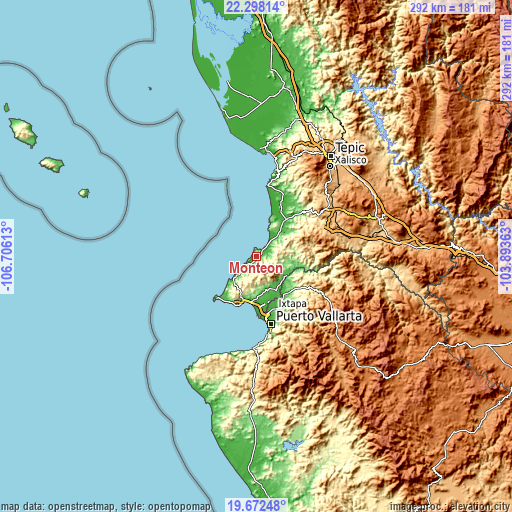
| \ | Map #1 | Topo.Map |
| Scale [m] | -8..484 m | × |
| Scale [ft] | -26..1588 ft | × |
| Average | 73.5 m = 241 ft | × |
| Width | 9.12 km = 5.7 mi | 291.9 km = 181.4 mi |
| Height | 9.12 km = 5.7 mi | 292 km = 181.4 mi |
| ↑Max Latitude | 21.032103° | 22.29814° |
| Latitude at center | 20.99108° | 20.99108° |
| ↓Min Latitude | 20.950045° | 19.67248° |
| ← Min Longitude | -105.343825° | -106.70613° |
| Longitude center | -105.29988° | -105.29988° |
| →Max Longitude | -105.255935° | -103.89363° |
Nearby cities:
Cities around Monteón sort by population:
• San José del Valle elevation 24 m
26.4 km,  163°
163°
• Las Varas 27 m
27 km,  38°
38°
• Bucerías 24 m
26.4 km,  187°
187°
• San Juan de Abajo 37 m
22.6 km,  150°
150°
• La Peñita de Jaltomba 8 m
7.6 km,  45°
45°
• Valle de Banderas 63 m
21.1 km,  165°
165°
• Colonia Paraíso Escondido 8 m
9.4 km, 42°
• Sayulita 8 m
19.8 km,  227°
227°
• Rincón de Guayabitos 9 m
4.7 km, 40°
• San Francisco 14 m
15.4 km, 229°
• Lo de Marcos 9 m
6.7 km, 233°
• El Colomo 61 m
20.1 km,  132°
132°
Multilingual:
 En español:
Monteón elevación 15 m.
 En France:
Monteón élévation 15 m.


Sources and notes:
- [note 1] Map square and city borders are not equal. Map elevation data is calculated only from area inside that square.
- [src 1] Elevation data from geonames database provided with same terms of usage.
- [src 2] The elevation map of Monteón is generated using elevation data from NASA's 3 arcsec (90m) resolution SRTM data.
- [src 3] Base (background) map © OpenStreetMap contributors tiles are generated by Geofabrik and OpenTopoMap.
Copyright & License:
This Monteón Elevation Map is licensed under CC BY-SA. You may reuse any part from this page, if you give a proper credit by linking to this URL:
 More info on terms of use page.