Sayulita elevation
Sayulita (Nayarit, Bahía de Banderas), Mexico elevation is 8 meters and Sayulita elevation in feet is 26 ft above sea level [src 1]. Sayulita is a populated place (feature code) with elevation that is 1306 meters (4285 ft) smaller than average city elevation in Mexico.
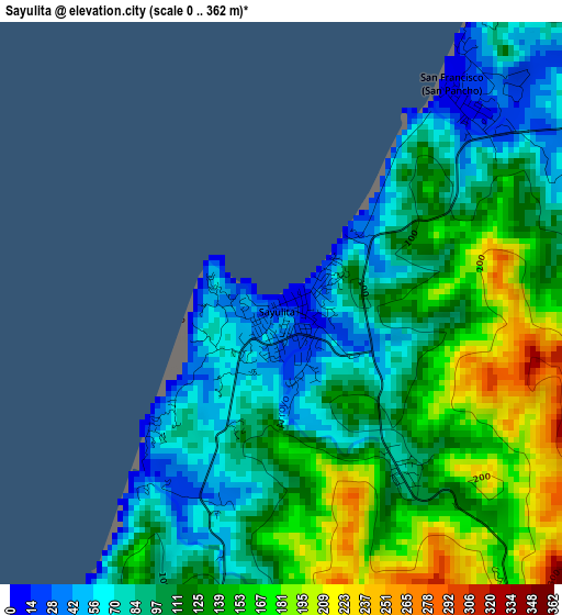
Below is the Elevation map of Sayulita, which displays elevation range with different colors. Scale of the first map is from 0 to 362 m (0 to 1188 ft) with average elevation of 118.2 meters (=388 ft) [note 1]
These maps also provides idea of topography and contour of this city, they are displayed at different zoom levels. More info about maps, scale and edge coordinates you can find below images.
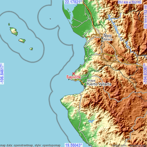
| \ | Map #1 | Topo.Map |
| Scale [m] | 0..362 m | × |
| Scale [ft] | 0..1188 ft | × |
| Average | 118.2 m = 388 ft | × |
| Width | 9.13 km = 5.7 mi | 292.2 km = 181.6 mi |
| Height | 9.13 km = 5.7 mi | 292.2 km = 181.6 mi |
| ↑Max Latitude | 20.911116° | 22.17821° |
| Latitude at center | 20.87006° | 20.87006° |
| ↓Min Latitude | 20.828992° | 19.55043° |
| ← Min Longitude | -105.483865° | -106.84617° |
| Longitude center | -105.43992° | -105.43992° |
| →Max Longitude | -105.395975° | -104.03367° |
Nearby cities:
Cities around Sayulita sort by population:
• Mezcales elevation 18 m
22.5 km,  133°
133°
• San Vicente 18 m
23.9 km,  124°
124°
• Bucerías 24 m
16.7 km,  139°
139°
• Valle de Banderas 63 m
21.1 km,  109°
109°
• Cruz de Huanacaxtle 17 m
14.4 km,  153°
153°
• Corral del Risco (Punta de Mita) 11 m
13.4 km,  216°
216°
• San Francisco 14 m
4.5 km,  38°
38°
• Monteón 15 m
19.8 km,  47°
47°
• Lo de Marcos 9 m
13.1 km, 43°
• Higuera Blanca 39 m
8.6 km,  199°
199°
• Nuevo Vallarta 8 m
24.1 km, 141°
• San Clemente de Lima 13 m
23 km, 130°
Multilingual:
 En español:
Sayulita elevación 8 m.
 En France:
Sayulita élévation 8 m.


Sources and notes:
- [note 1] Map square and city borders are not equal. Map elevation data is calculated only from area inside that square.
- [src 1] Elevation data from geonames database provided with same terms of usage.
- [src 2] The elevation map of Sayulita is generated using elevation data from NASA's 3 arcsec (90m) resolution SRTM data.
- [src 3] Base (background) map © OpenStreetMap contributors tiles are generated by Geofabrik and OpenTopoMap.
Copyright & License:
This Sayulita Elevation Map is licensed under CC BY-SA. You may reuse any part from this page, if you give a proper credit by linking to this URL:
 More info on terms of use page.