Pastoría elevation
Pastoría (Zacatecas, Ojocaliente), Mexico elevation is 2229 meters and Pastoría elevation in feet is 7313 ft above sea level [src 1]. Pastoría is a populated place (feature code) with elevation that is 915 meters (3002 ft) bigger than average city elevation in Mexico.
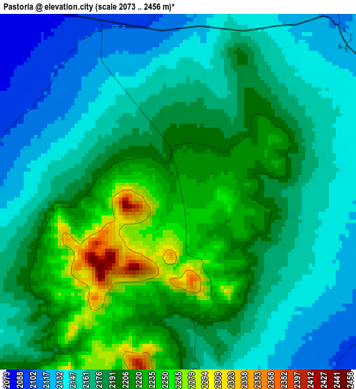
Below is the Elevation map of Pastoría, which displays elevation range with different colors. Scale of the first map is from 2073 to 2456 m (6801 to 8058 ft) with average elevation of 2180.9 meters (=7155 ft) [note 1]
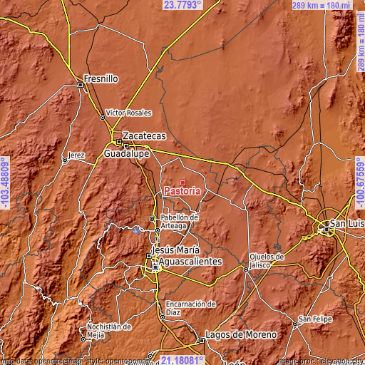
These maps also provides idea of topography and contour of this city, they are displayed at different zoom levels. More info about maps, scale and edge coordinates you can find below images.
| \ | Map #1 | Topo.Map |
| Scale [m] | 2073..2456 m | × |
| Scale [ft] | 6801..8058 ft | × |
| Average | 2180.9 m = 7155 ft | × |
| Width | 9.03 km = 5.6 mi | 288.9 km = 179.5 mi |
| Height | 9.03 km = 5.6 mi | 288.9 km = 179.5 mi |
| ↑Max Latitude | 22.526748° | 23.7793° |
| Latitude at center | 22.48615° | 22.48615° |
| ↓Min Latitude | 22.44554° | 21.18081° |
| ← Min Longitude | -102.125785° | -103.48809° |
| Longitude center | -102.08184° | -102.08184° |
| →Max Longitude | -102.037895° | -100.67559° |
Nearby cities:
Cities around Pastoría sort by population:
• Luis Moya elevation 1983 m
18.2 km,  250°
250°
• Villa González Ortega 2140 m
17.3 km,  80°
80°
• Estancia de Ánimas 2097 m
8.9 km,  88°
88°
• Tierra Blanca 2025 m
15.5 km,  173°
173°
• Maravillas 2051 m
11.7 km,  145°
145°
• Santa Elena 2047 m
11.9 km,  5°
5°
• San Pablo 2061 m
8.3 km,  347°
347°
• Bajío de San Nicolás 2100 m
11.6 km,  40°
40°
• El Tule 2034 m
17.8 km, 14°
• Milagros 2158 m
10.6 km,  278°
278°
• Colonia Hidalgo (El Tecolote) 2023 m
18 km,  164°
164°
• General Lauro G. Caloca (El Rascón) 2042 m
12.3 km, 168°
Multilingual:
 En español:
Pastoría elevación 2229 m.
 En France:
Pastoría élévation 2229 m.
 Auf Deutsch:
Pastoría höhe über dem Meeresspiegel ist 2229 m.

Sources and notes:
- [note 1] Map square and city borders are not equal. Map elevation data is calculated only from area inside that square.
- [src 1] Elevation data from geonames database provided with same terms of usage.
- [src 2] The elevation map of Pastoría is generated using elevation data from NASA's 3 arcsec (90m) resolution SRTM data.
- [src 3] Base (background) map © OpenStreetMap contributors tiles are generated by Geofabrik and OpenTopoMap.
Copyright & License:
This Pastoría Elevation Map is licensed under CC BY-SA. You may reuse any part from this page, if you give a proper credit by linking to this URL:
 More info on terms of use page.