Villa González Ortega elevation
Villa González Ortega (Zacatecas), Mexico elevation is 2140 meters and Villa González Ortega elevation in feet is 7021 ft above sea level [src 1]. Villa González Ortega is a seat of a second-order administrative division (feature code) with elevation that is 826 meters (2710 ft) bigger than average city elevation in Mexico.
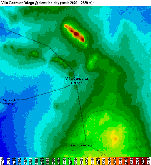
Below is the Elevation map of Villa González Ortega, which displays elevation range with different colors. Scale of the first map is from 2106 to 2237 m (6909 to 7339 ft) with average elevation of 2158.4 meters (=7081 ft) [note 1]
These maps also provides idea of topography and contour of this city, they are displayed at different zoom levels. More info about maps, scale and edge coordinates you can find below images.

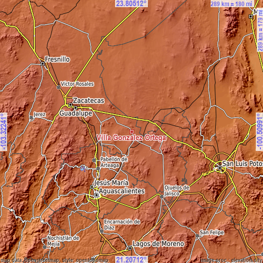
| \ | Map #1 | Map #2 | Topo.Map |
| Scale [m] | 2106..2237 m | 2070..2389 m | × |
| Scale [ft] | 6909..7339 ft | 6791..7838 ft | × |
| Average | 2158.4 m = 7081 ft | 2154.4 m = 7068 ft | × |
| Width | 9.03 km = 5.6 mi | 18.06 km = 11.2 mi | 288.9 km = 179.5 mi |
| Height | 9.03 km = 5.6 mi | 18.06 km = 11.2 mi | 288.9 km = 179.5 mi |
| ↑Max Latitude | 22.552811° | 22.593389° | 23.80512° |
| Latitude at center | 22.51222° | 22.51222° | 22.51222° |
| ↓Min Latitude | 22.471617° | 22.431003° | 21.20712° |
| ← Min Longitude | -101.960105° | -102.004051° | -103.32241° |
| Longitude center | -101.91616° | -101.91616° | -101.91616° |
| →Max Longitude | -101.872215° | -101.828269° | -100.50991° |
Nearby cities:
Cities around Villa González Ortega sort by population:
• Estancia de Ánimas elevation 2097 m
8.6 km,  251°
251°
• Maravillas 2051 m
16.2 km,  219°
219°
• Santa Elena 2047 m
18.3 km,  299°
299°
• Noria de Ángeles 2198 m
7.7 km,  174°
174°
• San Pablo 2061 m
19.6 km,  285°
285°
• Bajío de San Nicolás 2100 m
11.1 km, 301°
• El Tule 2034 m
19.1 km,  318°
318°
• La Ballena 2270 m
22.3 km,  106°
106°
• Colonia José María Morelos 2128 m
20.3 km,  142°
142°
• Ignacio Zaragoza 2146 m
21.5 km,  154°
154°
• General Lauro G. Caloca (El Rascón) 2042 m
20.8 km, 224°
• Pastoría 2229 m
17.3 km,  260°
260°
Multilingual:
 En español:
Villa González Ortega elevación 2140 m.
 En France:
Villa González Ortega élévation 2140 m.
 Auf Deutsch:
Villa González Ortega höhe über dem Meeresspiegel ist 2140 m.
 На русском:
Villa González Ortega высота над уровнем моря 2140 м
Sources and notes:
- [note 1] Map square and city borders are not equal. Map elevation data is calculated only from area inside that square.
- [src 1] Elevation data from geonames database provided with same terms of usage.
- [src 2] The elevation map of Villa González Ortega is generated using elevation data from NASA's 3 arcsec (90m) resolution SRTM data.
- [src 3] Base (background) map © OpenStreetMap contributors tiles are generated by Geofabrik and OpenTopoMap.
Copyright & License:
This Villa González Ortega Elevation Map is licensed under CC BY-SA. You may reuse any part from this page, if you give a proper credit by linking to this URL:
 More info on terms of use page.