Morelos elevation
Morelos (Chihuahua), Mexico elevation is 582 meters and Morelos elevation in feet is 1909 ft above sea level [src 1]. Morelos is a seat of a second-order administrative division (feature code) with elevation that is 732 meters (2402 ft) smaller than average city elevation in Mexico.
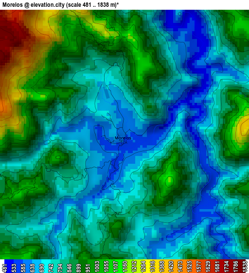
Below is the Elevation map of Morelos, which displays elevation range with different colors. Scale of the first map is from 481 to 1838 m (1578 to 6030 ft) with average elevation of 840.1 meters (=2756 ft) [note 1]
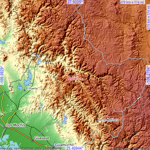
These maps also provides idea of topography and contour of this city, they are displayed at different zoom levels. More info about maps, scale and edge coordinates you can find below images.
| \ | Map #1 | Topo.Map |
| Scale [m] | 481..1838 m | × |
| Scale [ft] | 1578..6030 ft | × |
| Average | 840.1 m = 2756 ft | × |
| Width | 8.73 km = 5.4 mi | 279.4 km = 173.6 mi |
| Height | 8.73 km = 5.4 mi | 279.4 km = 173.6 mi |
| ↑Max Latitude | 26.712152° | 27.9225° |
| Latitude at center | 26.67289° | 26.67289° |
| ↓Min Latitude | 26.633614° | 25.40944° |
| ← Min Longitude | -107.720595° | -109.0829° |
| Longitude center | -107.67665° | -107.67665° |
| →Max Longitude | -107.632705° | -106.2704° |
Nearby cities:
Cities around Morelos sort by population:
• Guachochi elevation 2398 m
62 km,  74°
74°
• Choix 240 m
64.6 km,  273°
273°
• Baborigame 1985 m
48.8 km,  123°
123°
• San Rafael 2174 m
94.1 km,  346°
346°
• Témoris 1442 m
89.8 km,  318°
318°
• Cerocahui 1627 m
79.1 km,  331°
331°
• Agua Caliente Grande (De Gastélum) 272 m
68.4 km,  257°
257°
• Bahuichivo 1639 m
90.6 km, 334°
• Chinobampo 287 m
75.3 km,  245°
245°
• Samachique 2143 m
71.2 km,  11°
11°
• Batopilas 636 m
40.1 km, 350°
• Urique 551 m
64.3 km,  338°
338°
Multilingual:
 En español:
Morelos elevación 582 m.
 En France:
Morelos élévation 582 m.


Sources and notes:
- [note 1] Map square and city borders are not equal. Map elevation data is calculated only from area inside that square.
- [src 1] Elevation data from geonames database provided with same terms of usage.
- [src 2] The elevation map of Morelos is generated using elevation data from NASA's 3 arcsec (90m) resolution SRTM data.
- [src 3] Base (background) map © OpenStreetMap contributors tiles are generated by Geofabrik and OpenTopoMap.
Copyright & License:
This Morelos Elevation Map is licensed under CC BY-SA. You may reuse any part from this page, if you give a proper credit by linking to this URL:
 More info on terms of use page.