Témoris elevation
Témoris (Chihuahua, Guazapares), Mexico elevation is 1442 meters and Témoris elevation in feet is 4731 ft above sea level [src 1]. Témoris is a seat of a second-order administrative division (feature code) with elevation that is 128 meters (420 ft) bigger than average city elevation in Mexico.
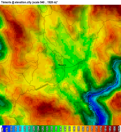
Below is the Elevation map of Témoris, which displays elevation range with different colors. Scale of the first map is from 940 to 1928 m (3084 to 6325 ft) with average elevation of 1530.9 meters (=5023 ft) [note 1]
These maps also provides idea of topography and contour of this city, they are displayed at different zoom levels. More info about maps, scale and edge coordinates you can find below images.
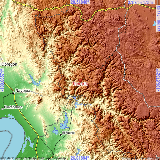
| \ | Map #1 | Topo.Map |
| Scale [m] | 940..1928 m | × |
| Scale [ft] | 3084..6325 ft | × |
| Average | 1530.9 m = 5023 ft | × |
| Width | 8.69 km = 5.4 mi | 277.9 km = 172.7 mi |
| Height | 8.69 km = 5.4 mi | 277.9 km = 172.7 mi |
| ↑Max Latitude | 27.314742° | 28.51848° |
| Latitude at center | 27.27569° | 27.27569° |
| ↓Min Latitude | 27.236624° | 26.01884° |
| ← Min Longitude | -108.323405° | -109.68571° |
| Longitude center | -108.27946° | -108.27946° |
| →Max Longitude | -108.235515° | -106.87321° |
Nearby cities:
Cities around Témoris sort by population:
• Álamos elevation 381 m
70.6 km,  246°
246°
• Choix 240 m
63.2 km,  184°
184°
• San Rafael 2174 m
45.6 km,  57°
57°
• Chínipas 439 m
28.7 km,  297°
297°
• Cerocahui 1627 m
22.3 km,  83°
83°
• Bahuichivo 1639 m
25.7 km,  54°
54°
• Batopilas 636 m
59.9 km,  117°
117°
• Uruachi 1356 m
66.1 km,  5°
5°
• Urique 551 m
36.8 km,  101°
101°
• San Bernardo 210 m
57.5 km,  283°
283°
• Milpillas 1380 m
37 km,  257°
257°
• Maguarichi 1676 m
70.7 km,  23°
23°
Multilingual:
 En español:
Témoris elevación 1442 m.
 En France:
Témoris élévation 1442 m.
 Auf Deutsch:
Témoris höhe über dem Meeresspiegel ist 1442 m.

Sources and notes:
- [note 1] Map square and city borders are not equal. Map elevation data is calculated only from area inside that square.
- [src 1] Elevation data from geonames database provided with same terms of usage.
- [src 2] The elevation map of Témoris is generated using elevation data from NASA's 3 arcsec (90m) resolution SRTM data.
- [src 3] Base (background) map © OpenStreetMap contributors tiles are generated by Geofabrik and OpenTopoMap.
Copyright & License:
This Témoris Elevation Map is licensed under CC BY-SA. You may reuse any part from this page, if you give a proper credit by linking to this URL:
 More info on terms of use page.