San Antonio elevation
San Antonio (Aguascalientes, Tepezalá), Mexico elevation is 1918 meters and San Antonio elevation in feet is 6293 ft above sea level [src 1]. San Antonio is a populated place (feature code) with elevation that is 604 meters (1982 ft) bigger than average city elevation in Mexico.
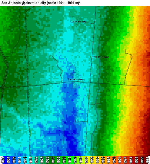
Below is the Elevation map of San Antonio, which displays elevation range with different colors. Scale of the first map is from 1901 to 1991 m (6237 to 6532 ft) with average elevation of 1931.3 meters (=6336 ft) [note 1]
These maps also provides idea of topography and contour of this city, they are displayed at different zoom levels. More info about maps, scale and edge coordinates you can find below images.
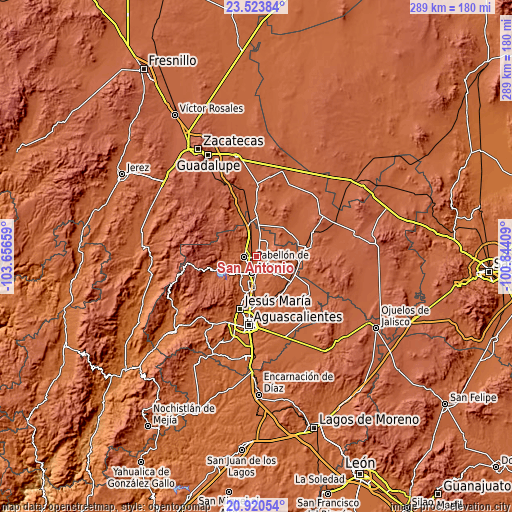
| \ | Map #1 | Topo.Map |
| Scale [m] | 1901..1991 m | × |
| Scale [ft] | 6237..6532 ft | × |
| Average | 1931.3 m = 6336 ft | × |
| Width | 9.05 km = 5.6 mi | 289.5 km = 179.9 mi |
| Height | 9.05 km = 5.6 mi | 289.5 km = 179.9 mi |
| ↑Max Latitude | 22.268904° | 23.52384° |
| Latitude at center | 22.22823° | 22.22823° |
| ↓Min Latitude | 22.187545° | 20.92054° |
| ← Min Longitude | -102.294285° | -103.65659° |
| Longitude center | -102.25034° | -102.25034° |
| →Max Longitude | -102.206395° | -100.84409° |
Nearby cities:
Cities around San Antonio sort by population:
• Pabellón de Arteaga elevation 1910 m
9.5 km,  196°
196°
• Rincón de Romos 1945 m
7.4 km,  269°
269°
• Tepezalá 2121 m
8.3 km,  93°
93°
• Pabellón de Hidalgo 1934 m
10.8 km,  239°
239°
• Escaleras 1981 m
8.9 km,  286°
286°
• La Punta 1957 m
11.5 km,  338°
338°
• San Jacinto 1949 m
13.5 km,  7°
7°
• El Chayote 1928 m
6.6 km, 10°
• El Refugio de Providencia (Providencia) 1951 m
13.2 km,  356°
356°
• El Bajío 1944 m
6.3 km, 287°
• Carboneras 1911 m
5 km,  174°
174°
• San Luis de Letras 1898 m
11.4 km,  205°
205°
Multilingual:
 En español:
San Antonio elevación 1918 m.
 En France:
San Antonio élévation 1918 m.
 Auf Deutsch:
San Antonio höhe über dem Meeresspiegel ist 1918 m.

Sources and notes:
- [note 1] Map square and city borders are not equal. Map elevation data is calculated only from area inside that square.
- [src 1] Elevation data from geonames database provided with same terms of usage.
- [src 2] The elevation map of San Antonio is generated using elevation data from NASA's 3 arcsec (90m) resolution SRTM data.
- [src 3] Base (background) map © OpenStreetMap contributors tiles are generated by Geofabrik and OpenTopoMap.
Copyright & License:
This San Antonio Elevation Map is licensed under CC BY-SA. You may reuse any part from this page, if you give a proper credit by linking to this URL:
 More info on terms of use page.