San José Iturbide elevation
San José Iturbide (Guanajuato), Mexico elevation is 2102 meters and San José Iturbide elevation in feet is 6896 ft above sea level [src 1]. San José Iturbide is a seat of a second-order administrative division (feature code) with elevation that is 788 meters (2585 ft) bigger than average city elevation in Mexico.
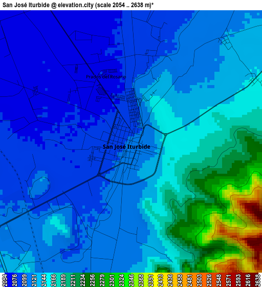
Below is the Elevation map of San José Iturbide, which displays elevation range with different colors. Scale of the first map is from 2054 to 2638 m (6739 to 8655 ft) with average elevation of 2138 meters (=7014 ft) [note 1]
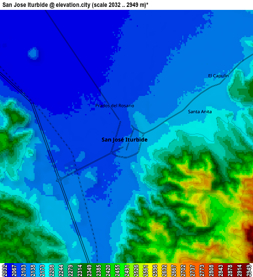
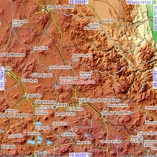
These maps also provides idea of topography and contour of this city, they are displayed at different zoom levels. More info about maps, scale and edge coordinates you can find below images.
| \ | Map #1 | Map #2 | Topo.Map |
| Scale [m] | 2054..2638 m | 2032..2949 m | × |
| Scale [ft] | 6739..8655 ft | 6667..9675 ft | × |
| Average | 2138 m = 7014 ft | 2195.6 m = 7203 ft | × |
| Width | 9.12 km = 5.7 mi | 18.25 km = 11.3 mi | 291.9 km = 181.4 mi |
| Height | 9.12 km = 5.7 mi | 18.25 km = 11.3 mi | 291.9 km = 181.4 mi |
| ↑Max Latitude | 21.04255° | 21.08356° | 22.30849° |
| Latitude at center | 21.00153° | 21.00153° | 21.00153° |
| ↓Min Latitude | 20.960498° | 20.919455° | 19.68302° |
| ← Min Longitude | -100.428105° | -100.472051° | -101.79041° |
| Longitude center | -100.38416° | -100.38416° | -100.38416° |
| →Max Longitude | -100.340215° | -100.296269° | -98.97791° |
Nearby cities:
Cities around San José Iturbide sort by population:
• La Gotera elevation 2212 m
15.4 km,  176°
176°
• El Capulín 2136 m
7.8 km,  56°
56°
• La Versolilla 2173 m
14.3 km, 177°
• San Sebastián de Salitre 2028 m
15.1 km,  318°
318°
• Ojo de Agua del Refugio 2188 m
7.1 km,  78°
78°
• La Luz 2118 m
15.8 km,  200°
200°
• Santa Anita 2160 m
5.6 km,  70°
70°
• Palo Alto 2099 m
15.1 km,  186°
186°
• Rincón de Cano 1919 m
15.9 km, 67°
• Puerto de Carroza 2135 m
11.8 km, 194°
• Prados del Rosario 2073 m
2.4 km,  339°
339°
• Tulillos de Abajo 2031 m
14 km,  312°
312°
Multilingual:
 En español:
San Jose Iturbide elevación 2102 m.
 En France:
San José Iturbide élévation 2102 m.
 Auf Deutsch:
San José Iturbide höhe über dem Meeresspiegel ist 2102 m.
 На русском:
San José Iturbide высота над уровнем моря 2102 м
Sources and notes:
- [note 1] Map square and city borders are not equal. Map elevation data is calculated only from area inside that square.
- [src 1] Elevation data from geonames database provided with same terms of usage.
- [src 2] The elevation map of San José Iturbide is generated using elevation data from NASA's 3 arcsec (90m) resolution SRTM data.
- [src 3] Base (background) map © OpenStreetMap contributors tiles are generated by Geofabrik and OpenTopoMap.
Copyright & License:
This San José Iturbide Elevation Map is licensed under CC BY-SA. You may reuse any part from this page, if you give a proper credit by linking to this URL:
 More info on terms of use page.