La Gotera elevation
La Gotera (Querétaro), Mexico elevation is 2212 meters and La Gotera elevation in feet is 7257 ft above sea level [src 1]. La Gotera is a populated place (feature code) with elevation that is 898 meters (2946 ft) bigger than average city elevation in Mexico.
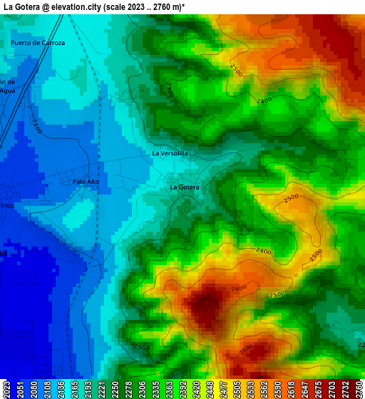
Below is the Elevation map of La Gotera, which displays elevation range with different colors. Scale of the first map is from 2023 to 2760 m (6637 to 9055 ft) with average elevation of 2285.4 meters (=7498 ft) [note 1]
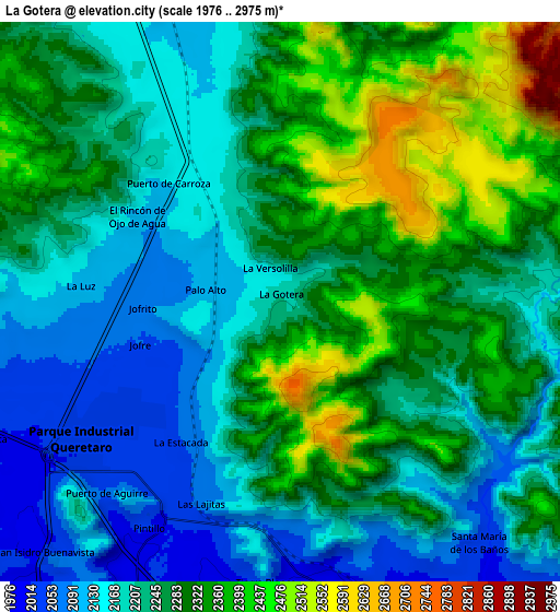
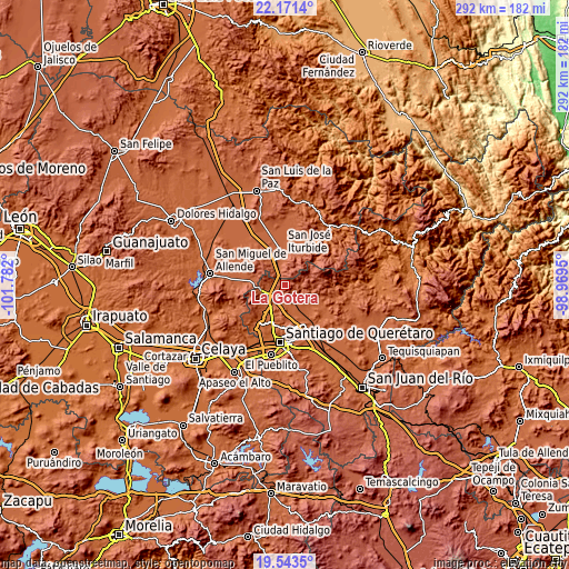
These maps also provides idea of topography and contour of this city, they are displayed at different zoom levels. More info about maps, scale and edge coordinates you can find below images.
| \ | Map #1 | Map #2 | Topo.Map |
| Scale [m] | 2023..2760 m | 1976..2975 m | × |
| Scale [ft] | 6637..9055 ft | 6483..9760 ft | × |
| Average | 2285.4 m = 7498 ft | 2254.6 m = 7397 ft | × |
| Width | 9.13 km = 5.7 mi | 18.26 km = 11.3 mi | 292.2 km = 181.6 mi |
| Height | 9.13 km = 5.7 mi | 18.26 km = 11.3 mi | 292.2 km = 181.6 mi |
| ↑Max Latitude | 20.904248° | 20.945295° | 22.1714° |
| Latitude at center | 20.86319° | 20.86319° | 20.86319° |
| ↓Min Latitude | 20.82212° | 20.78104° | 19.5435° |
| ← Min Longitude | -100.419695° | -100.463641° | -101.782° |
| Longitude center | -100.37575° | -100.37575° | -100.37575° |
| →Max Longitude | -100.331805° | -100.287859° | -98.9695° |
Nearby cities:
Cities around La Gotera sort by population:
• Tierra Blanca elevation 2031 m
9.2 km,  182°
182°
• Puerto de Aguirre 2056 m
8.6 km,  222°
222°
• Los Pocitos 2058 m
9.5 km,  137°
137°
• La Estacada 2049 m
5.7 km, 215°
• La Versolilla 2173 m
1.1 km,  343°
343°
• Jofrito 2066 m
4.5 km,  267°
267°
• La Luz 2118 m
6.5 km,  275°
275°
• El Pinto 2023 m
7.7 km,  208°
208°
• Palo Alto 2099 m
2.5 km, 278°
• Puerto de Carroza 2135 m
5.4 km,  316°
316°
• Pintillo 2023 m
8.5 km, 210°
• Las Lajitas 2075 m
7.1 km,  201°
201°
Multilingual:
 En español:
La Gotera elevación 2212 m.
 En France:
La Gotera élévation 2212 m.
 Auf Deutsch:
La Gotera höhe über dem Meeresspiegel ist 2212 m.

Sources and notes:
- [note 1] Map square and city borders are not equal. Map elevation data is calculated only from area inside that square.
- [src 1] Elevation data from geonames database provided with same terms of usage.
- [src 2] The elevation map of La Gotera is generated using elevation data from NASA's 3 arcsec (90m) resolution SRTM data.
- [src 3] Base (background) map © OpenStreetMap contributors tiles are generated by Geofabrik and OpenTopoMap.
Copyright & License:
This La Gotera Elevation Map is licensed under CC BY-SA. You may reuse any part from this page, if you give a proper credit by linking to this URL:
 More info on terms of use page.