Xoconoxtle el Grande elevation
Xoconoxtle el Grande (Guanajuato, Dolores Hidalgo Cuna de la Independencia Nacional), Mexico elevation is 1979 meters and Xoconoxtle el Grande elevation in feet is 6493 ft above sea level [src 1]. Xoconoxtle el Grande is a populated place (feature code) with elevation that is 665 meters (2182 ft) bigger than average city elevation in Mexico.
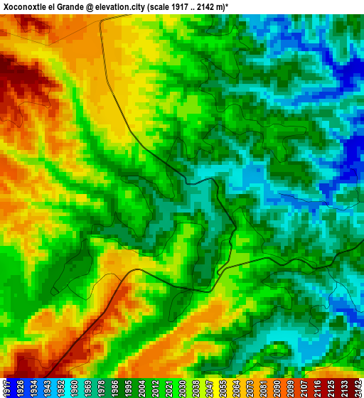
Below is the Elevation map of Xoconoxtle el Grande, which displays elevation range with different colors. Scale of the first map is from 1917 to 2142 m (6289 to 7028 ft) with average elevation of 2016.4 meters (=6615 ft) [note 1]
These maps also provides idea of topography and contour of this city, they are displayed at different zoom levels. More info about maps, scale and edge coordinates you can find below images.
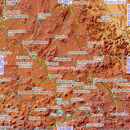
| \ | Map #1 | Topo.Map |
| Scale [m] | 1917..2142 m | × |
| Scale [ft] | 6289..7028 ft | × |
| Average | 2016.4 m = 6615 ft | × |
| Width | 9.13 km = 5.7 mi | 292 km = 181.4 mi |
| Height | 9.13 km = 5.7 mi | 292.1 km = 181.5 mi |
| ↑Max Latitude | 20.979608° | 22.2461° |
| Latitude at center | 20.93857° | 20.93857° |
| ↓Min Latitude | 20.897521° | 19.61952° |
| ← Min Longitude | -101.025435° | -102.38774° |
| Longitude center | -100.98149° | -100.98149° |
| →Max Longitude | -100.937545° | -99.57524° |
Nearby cities:
Cities around Xoconoxtle el Grande sort by population:
• La Sauceda elevation 1939 m
22.2 km,  258°
258°
• Landín 1949 m
22 km,  159°
159°
• Santa Teresita de Don Diego 1896 m
22.1 km,  107°
107°
• Palmillas de San Juan 1987 m
22.5 km,  147°
147°
• Tequisquiapan 1879 m
22.9 km,  46°
46°
• La Cieneguita 1857 m
19.9 km,  87°
87°
• San Antonio de Corrales 2001 m
21.5 km,  175°
175°
• El Llanito 1934 m
20.6 km,  8°
8°
• Nigromante 1891 m
21.1 km,  82°
82°
• Adjuntas del Río 1914 m
23 km,  30°
30°
• Don Francisco 1918 m
7.6 km,  121°
121°
• La Cruz del Palmar 1866 m
14.7 km, 76°
Multilingual:
 En español:
Xoconoxtle el Grande elevación 1979 m.
 En France:
Xoconoxtle el Grande élévation 1979 m.
 Auf Deutsch:
Xoconoxtle el Grande höhe über dem Meeresspiegel ist 1979 m.
 На русском:
Xoconoxtle el Grande высота над уровнем моря 1979 м
Sources and notes:
- [note 1] Map square and city borders are not equal. Map elevation data is calculated only from area inside that square.
- [src 1] Elevation data from geonames database provided with same terms of usage.
- [src 2] The elevation map of Xoconoxtle el Grande is generated using elevation data from NASA's 3 arcsec (90m) resolution SRTM data.
- [src 3] Base (background) map © OpenStreetMap contributors tiles are generated by Geofabrik and OpenTopoMap.
Copyright & License:
This Xoconoxtle el Grande Elevation Map is licensed under CC BY-SA. You may reuse any part from this page, if you give a proper credit by linking to this URL:
 More info on terms of use page.