San Miguel el Alto elevation
San Miguel el Alto (Jalisco), Mexico elevation is 1851 meters and San Miguel el Alto elevation in feet is 6073 ft above sea level [src 1]. San Miguel el Alto is a seat of a second-order administrative division (feature code) with elevation that is 537 meters (1762 ft) bigger than average city elevation in Mexico.
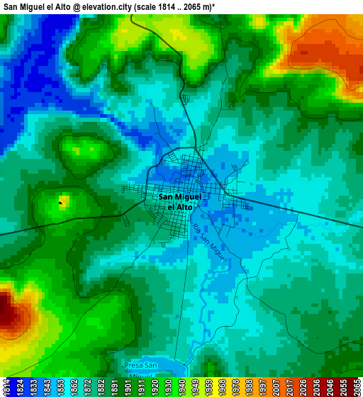
Below is the Elevation map of San Miguel el Alto, which displays elevation range with different colors. Scale of the first map is from 1814 to 2065 m (5951 to 6775 ft) with average elevation of 1886.9 meters (=6191 ft) [note 1]
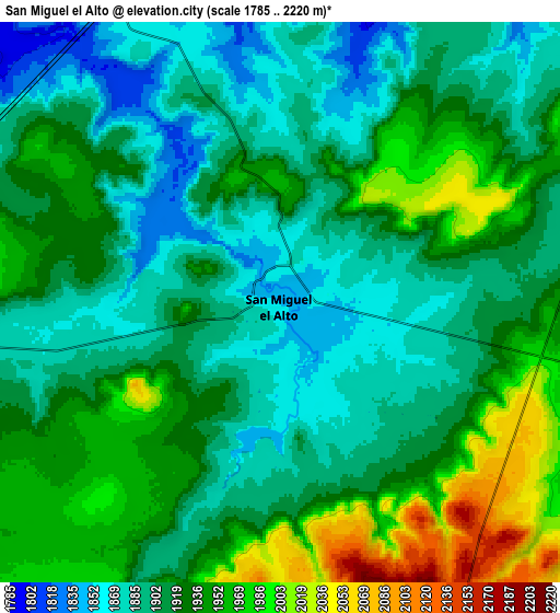
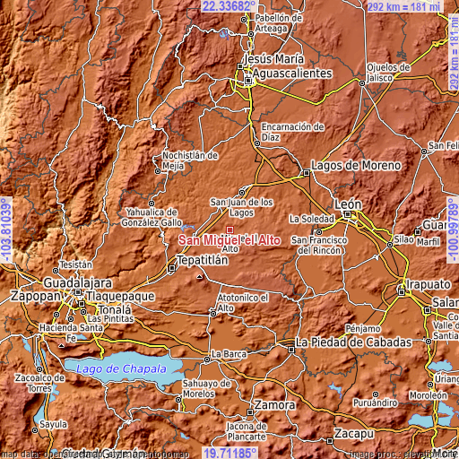
These maps also provides idea of topography and contour of this city, they are displayed at different zoom levels. More info about maps, scale and edge coordinates you can find below images.
| \ | Map #1 | Map #2 | Topo.Map |
| Scale [m] | 1814..2065 m | 1785..2220 m | × |
| Scale [ft] | 5951..6775 ft | 5856..7283 ft | × |
| Average | 1886.9 m = 6191 ft | 1921.1 m = 6303 ft | × |
| Width | 9.12 km = 5.7 mi | 18.24 km = 11.3 mi | 291.9 km = 181.4 mi |
| Height | 9.12 km = 5.7 mi | 18.24 km = 11.3 mi | 291.9 km = 181.4 mi |
| ↑Max Latitude | 21.071123° | 21.112124° | 22.33682° |
| Latitude at center | 21.03011° | 21.03011° | 21.03011° |
| ↓Min Latitude | 20.989086° | 20.948051° | 19.71185° |
| ← Min Longitude | -102.448085° | -102.492031° | -103.81039° |
| Longitude center | -102.40414° | -102.40414° | -102.40414° |
| →Max Longitude | -102.360195° | -102.316249° | -100.99789° |
Nearby cities:
Cities around San Miguel el Alto sort by population:
• San Juan de los Lagos elevation 1749 m
25.5 km,  17°
17°
• Jalostotitlán 1763 m
16.5 km,  337°
337°
• Capilla de Guadalupe 2058 m
29.8 km,  220°
220°
• San Julián 2068 m
23.4 km,  95°
95°
• Valle de Guadalupe 1826 m
22.2 km,  264°
264°
• Santa María del Valle 2065 m
17.1 km,  171°
171°
• Pegueros 1888 m
28.6 km,  252°
252°
• Colonia Santa Cecilia (La Sauceda) 1755 m
25.3 km,  12°
12°
• Cañadas de Obregón 1866 m
32.2 km,  294°
294°
• Colonia Veintitrés de Mayo 2065 m
21.5 km, 95°
• Mezquitic de la Magdalena 1724 m
23.6 km,  25°
25°
• San José de los Reynoso 1881 m
13.3 km,  69°
69°
Multilingual:
 En español:
San Miguel el Alto elevación 1851 m.
 En France:
San Miguel el Alto élévation 1851 m.
 Auf Deutsch:
San Miguel el Alto höhe über dem Meeresspiegel ist 1851 m.
 На русском:
San Miguel el Alto высота над уровнем моря 1851 м
Sources and notes:
- [note 1] Map square and city borders are not equal. Map elevation data is calculated only from area inside that square.
- [src 1] Elevation data from geonames database provided with same terms of usage.
- [src 2] The elevation map of San Miguel el Alto is generated using elevation data from NASA's 3 arcsec (90m) resolution SRTM data.
- [src 3] Base (background) map © OpenStreetMap contributors tiles are generated by Geofabrik and OpenTopoMap.
Copyright & License:
This San Miguel el Alto Elevation Map is licensed under CC BY-SA. You may reuse any part from this page, if you give a proper credit by linking to this URL:
 More info on terms of use page.