Santo Niño Aguanaval elevation
Santo Niño Aguanaval (Coahuila, Matamoros), Mexico elevation is 1141 meters and Santo Niño Aguanaval elevation in feet is 3743 ft above sea level [src 1]. Santo Niño Aguanaval is a populated place (feature code) with elevation that is 173 meters (568 ft) smaller than average city elevation in Mexico.
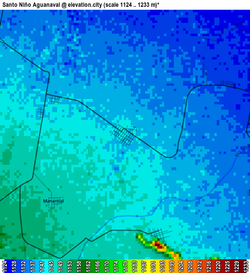
Below is the Elevation map of Santo Niño Aguanaval, which displays elevation range with different colors. Scale of the first map is from 1124 to 1233 m (3688 to 4045 ft) with average elevation of 1139.4 meters (=3738 ft) [note 1]
These maps also provides idea of topography and contour of this city, they are displayed at different zoom levels. More info about maps, scale and edge coordinates you can find below images.
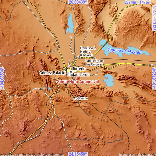
| \ | Map #1 | Topo.Map |
| Scale [m] | 1124..1233 m | × |
| Scale [ft] | 3688..4045 ft | × |
| Average | 1139.4 m = 3738 ft | × |
| Width | 8.83 km = 5.5 mi | 282.4 km = 175.5 mi |
| Height | 8.83 km = 5.5 mi | 282.4 km = 175.5 mi |
| ↑Max Latitude | 25.470861° | 26.69439° |
| Latitude at center | 25.43118° | 25.43118° |
| ↓Min Latitude | 25.391486° | 24.15458° |
| ← Min Longitude | -103.323035° | -104.68534° |
| Longitude center | -103.27909° | -103.27909° |
| →Max Longitude | -103.235145° | -101.87284° |
Nearby cities:
Cities around Santo Niño Aguanaval sort by population:
• Matamoros elevation 1117 m
11.8 km,  25°
25°
• San Pedro 1126 m
6.3 km,  87°
87°
• Nazareno 1176 m
14.7 km,  255°
255°
• Hidalgo 1112 m
15.3 km,  64°
64°
• Boquilla de las Perlas 1155 m
11.5 km,  184°
184°
• La Perla 1124 m
10.3 km,  315°
315°
• La Esperanza 1117 m
15 km,  359°
359°
• Fraccionamiento la Noria 1120 m
15.4 km,  335°
335°
• Gilita 1133 m
9 km,  117°
117°
• Rancho Alegre 1122 m
9.3 km,  328°
328°
• El Consuelo 1115 m
15.6 km,  1°
1°
• Las Mieleras 1143 m
3.7 km,  161°
161°
Multilingual:
 En español:
Santo Niño Aguanaval elevación 1141 m.
 En France:
Santo Niño Aguanaval élévation 1141 m.
 Auf Deutsch:
Santo Niño Aguanaval höhe über dem Meeresspiegel ist 1141 m.
 На русском:
Santo Niño Aguanaval высота над уровнем моря 1141 м
Sources and notes:
- [note 1] Map square and city borders are not equal. Map elevation data is calculated only from area inside that square.
- [src 1] Elevation data from geonames database provided with same terms of usage.
- [src 2] The elevation map of Santo Niño Aguanaval is generated using elevation data from NASA's 3 arcsec (90m) resolution SRTM data.
- [src 3] Base (background) map © OpenStreetMap contributors tiles are generated by Geofabrik and OpenTopoMap.
Copyright & License:
This Santo Niño Aguanaval Elevation Map is licensed under CC BY-SA. You may reuse any part from this page, if you give a proper credit by linking to this URL:
 More info on terms of use page.