Santo Tomás Huatzindeo elevation
Santo Tomás Huatzindeo (Guanajuato, Salvatierra), Mexico elevation is 1790 meters and Santo Tomás Huatzindeo elevation in feet is 5873 ft above sea level [src 1]. Santo Tomás Huatzindeo is a populated place (feature code) with elevation that is 476 meters (1562 ft) bigger than average city elevation in Mexico.
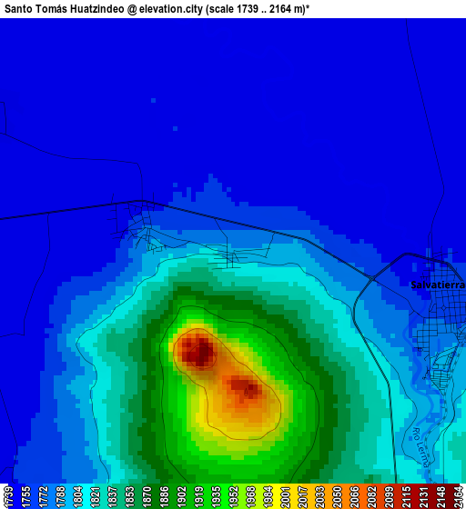
Below is the Elevation map of Santo Tomás Huatzindeo, which displays elevation range with different colors. Scale of the first map is from 1739 to 2164 m (5705 to 7100 ft) with average elevation of 1794.4 meters (=5887 ft) [note 1]
These maps also provides idea of topography and contour of this city, they are displayed at different zoom levels. More info about maps, scale and edge coordinates you can find below images.
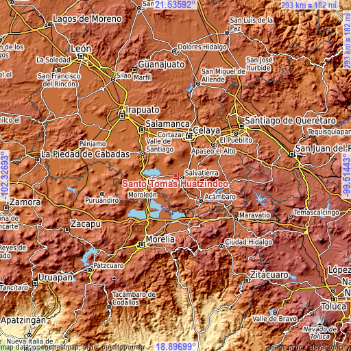
| \ | Map #1 | Topo.Map |
| Scale [m] | 1739..2164 m | × |
| Scale [ft] | 5705..7100 ft | × |
| Average | 1794.4 m = 5887 ft | × |
| Width | 9.17 km = 5.7 mi | 293.4 km = 182.3 mi |
| Height | 9.17 km = 5.7 mi | 293.4 km = 182.3 mi |
| ↑Max Latitude | 20.263281° | 21.53592° |
| Latitude at center | 20.22205° | 20.22205° |
| ↓Min Latitude | 20.180808° | 18.89699° |
| ← Min Longitude | -100.964625° | -102.32693° |
| Longitude center | -100.92068° | -100.92068° |
| →Max Longitude | -100.876735° | -99.51443° |
Nearby cities:
Cities around Santo Tomás Huatzindeo sort by population:
• Salvatierra elevation 1761 m
4.3 km,  103°
103°
• Urireo 1796 m
8.3 km, 96°
• San Nicolás de los Agustinos 1746 m
5.5 km,  299°
299°
• San Pedro de los Naranjos 1762 m
1.9 km,  287°
287°
• Santiago Maravatío 1744 m
9.5 km,  234°
234°
• Maravatío del Encinal 1747 m
4.7 km,  246°
246°
• Ojo de Agua de Ballesteros 1761 m
10.1 km,  86°
86°
• San Miguel Eménguaro 1808 m
7.4 km,  150°
150°
• La Luz 1746 m
7.4 km,  2°
2°
• El Capulín 1752 m
9 km,  311°
311°
• El Salvador (Ranchito San José del Carmen) 1752 m
8.6 km,  31°
31°
• San Antonio Eménguaro 1809 m
10.1 km, 154°
Multilingual:
 En español:
Santo Tomás Huatzindeo elevación 1790 m.
 En France:
Santo Tomás Huatzindeo élévation 1790 m.
 Auf Deutsch:
Santo Tomás Huatzindeo höhe über dem Meeresspiegel ist 1790 m.
 На русском:
Santo Tomás Huatzindeo высота над уровнем моря 1790 м
Sources and notes:
- [note 1] Map square and city borders are not equal. Map elevation data is calculated only from area inside that square.
- [src 1] Elevation data from geonames database provided with same terms of usage.
- [src 2] The elevation map of Santo Tomás Huatzindeo is generated using elevation data from NASA's 3 arcsec (90m) resolution SRTM data.
- [src 3] Base (background) map © OpenStreetMap contributors tiles are generated by Geofabrik and OpenTopoMap.
Copyright & License:
This Santo Tomás Huatzindeo Elevation Map is licensed under CC BY-SA. You may reuse any part from this page, if you give a proper credit by linking to this URL:
 More info on terms of use page.