Tancítaro elevation
Tancítaro (Michoacán), Mexico elevation is 2090 meters and Tancítaro elevation in feet is 6857 ft above sea level [src 1]. Tancítaro is a populated place (feature code) with elevation that is 776 meters (2546 ft) bigger than average city elevation in Mexico.
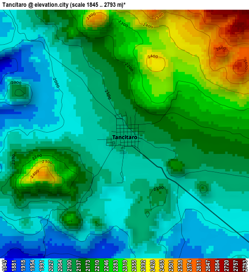
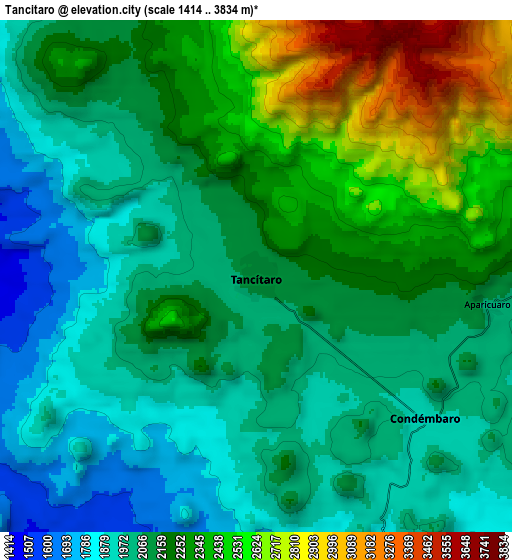
Below is the Elevation map of Tancítaro, which displays elevation range with different colors. Scale of the first map is from 1845 to 2793 m (6053 to 9163 ft) with average elevation of 2136.7 meters (=7010 ft) [note 1]
These maps also provides idea of topography and contour of this city, they are displayed at different zoom levels. More info about maps, scale and edge coordinates you can find below images.
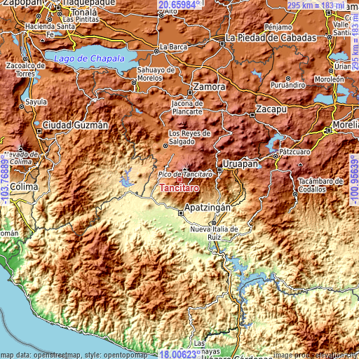
| \ | Map #1 | Map #2 | Topo.Map |
| Scale [m] | 1845..2793 m | 1414..3834 m | × |
| Scale [ft] | 6053..9163 ft | 4639..12579 ft | × |
| Average | 2136.7 m = 7010 ft | 2170.3 m = 7120 ft | × |
| Width | 9.22 km = 5.7 mi | 18.44 km = 11.5 mi | 295.1 km = 183.4 mi |
| Height | 9.22 km = 5.7 mi | 18.44 km = 11.5 mi | 295.1 km = 183.4 mi |
| ↑Max Latitude | 19.379891° | 19.421341° | 20.65984° |
| Latitude at center | 19.33843° | 19.33843° | 19.33843° |
| ↓Min Latitude | 19.296959° | 19.255477° | 18.00623° |
| ← Min Longitude | -102.406585° | -102.450531° | -103.76889° |
| Longitude center | -102.36264° | -102.36264° | -102.36264° |
| →Max Longitude | -102.318695° | -102.274749° | -100.95639° |
Nearby cities:
Cities around Tancítaro sort by population:
• Peribán de Ramos elevation 1650 m
20.9 km,  345°
345°
• Nuevo Zirosto 1914 m
23.4 km,  3°
3°
• San Francisco Peribán 1629 m
24.5 km, 351°
• San Juan De Los Platanos 276 m
23.8 km,  199°
199°
• Páreo 1428 m
9.4 km,  266°
266°
• Apo 2134 m
11.1 km,  332°
332°
• Santa Ana Zirosto 2034 m
22.2 km,  10°
10°
• Gildardo Magaña (Los Ángeles) 1382 m
25.5 km,  336°
336°
• Carona 1450 m
22.9 km, 336°
• Condémbaro 1947 m
8 km,  129°
129°
• San Juan de los Plátanos 272 m
23.9 km, 199°
• Santa Catarina 1782 m
6.5 km,  215°
215°
Multilingual:
 En español:
Tancítaro elevación 2090 m.
 En France:
Tancítaro élévation 2090 m.
 Auf Deutsch:
Tancítaro höhe über dem Meeresspiegel ist 2090 m.

Sources and notes:
- [note 1] Map square and city borders are not equal. Map elevation data is calculated only from area inside that square.
- [src 1] Elevation data from geonames database provided with same terms of usage.
- [src 2] The elevation map of Tancítaro is generated using elevation data from NASA's 3 arcsec (90m) resolution SRTM data.
- [src 3] Base (background) map © OpenStreetMap contributors tiles are generated by Geofabrik and OpenTopoMap.
Copyright & License:
This Tancítaro Elevation Map is licensed under CC BY-SA. You may reuse any part from this page, if you give a proper credit by linking to this URL:
 More info on terms of use page.