Peribán de Ramos elevation
Peribán de Ramos (Michoacán, Peribán), Mexico elevation is 1650 meters and Peribán de Ramos elevation in feet is 5413 ft above sea level [src 1]. Peribán de Ramos is a populated place (feature code) with elevation that is 336 meters (1102 ft) bigger than average city elevation in Mexico.
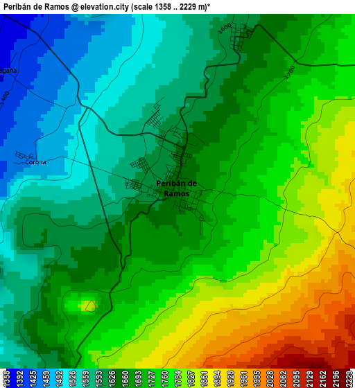
Below is the Elevation map of Peribán de Ramos, which displays elevation range with different colors. Scale of the first map is from 1358 to 2229 m (4455 to 7313 ft) with average elevation of 1689.5 meters (=5543 ft) [note 1]
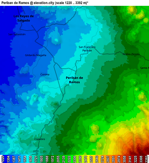
These maps also provides idea of topography and contour of this city, they are displayed at different zoom levels. More info about maps, scale and edge coordinates you can find below images.
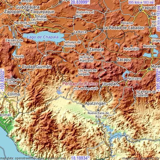
| \ | Map #1 | Map #2 | Topo.Map |
| Scale [m] | 1358..2229 m | 1220..3392 m | × |
| Scale [ft] | 4455..7313 ft | 4003..11129 ft | × |
| Average | 1689.5 m = 5543 ft | 1780.1 m = 5840 ft | × |
| Width | 9.21 km = 5.7 mi | 18.42 km = 11.4 mi | 294.7 km = 183.1 mi |
| Height | 9.21 km = 5.7 mi | 18.42 km = 11.4 mi | 294.7 km = 183.1 mi |
| ↑Max Latitude | 19.561514° | 19.602918° | 20.83999° |
| Latitude at center | 19.5201° | 19.5201° | 19.5201° |
| ↓Min Latitude | 19.478675° | 19.43724° | 18.18934° |
| ← Min Longitude | -102.457915° | -102.501861° | -103.82022° |
| Longitude center | -102.41397° | -102.41397° | -102.41397° |
| →Max Longitude | -102.370025° | -102.326079° | -101.00772° |
Nearby cities:
Cities around Peribán de Ramos sort by population:
• Los Reyes de Salgado elevation 1317 m
9.9 km,  321°
321°
• Santa Clara de Valladares 1323 m
15.3 km,  328°
328°
• Atapán 1582 m
14.5 km,  355°
355°
• Nuevo Zirosto 1914 m
7.6 km,  65°
65°
• San Sebastián 1310 m
9 km,  309°
309°
• San Francisco Peribán 1629 m
4.3 km,  22°
22°
• Apo 2134 m
10.3 km,  178°
178°
• Santa Ana Zirosto 2034 m
9.5 km,  79°
79°
• Gildardo Magaña (Los Ángeles) 1382 m
5.7 km,  304°
304°
• Los Limones 1250 m
15.1 km, 306°
• Carona 1450 m
3.9 km,  280°
280°
• La Higuerita (Colonia San Rafael) 1293 m
13.2 km, 326°
Multilingual:
 En español:
Peribán de Ramos elevación 1650 m.
 En France:
Peribán de Ramos élévation 1650 m.
 Auf Deutsch:
Peribán de Ramos höhe über dem Meeresspiegel ist 1650 m.

Sources and notes:
- [note 1] Map square and city borders are not equal. Map elevation data is calculated only from area inside that square.
- [src 1] Elevation data from geonames database provided with same terms of usage.
- [src 2] The elevation map of Peribán de Ramos is generated using elevation data from NASA's 3 arcsec (90m) resolution SRTM data.
- [src 3] Base (background) map © OpenStreetMap contributors tiles are generated by Geofabrik and OpenTopoMap.
Copyright & License:
This Peribán de Ramos Elevation Map is licensed under CC BY-SA. You may reuse any part from this page, if you give a proper credit by linking to this URL:
 More info on terms of use page.